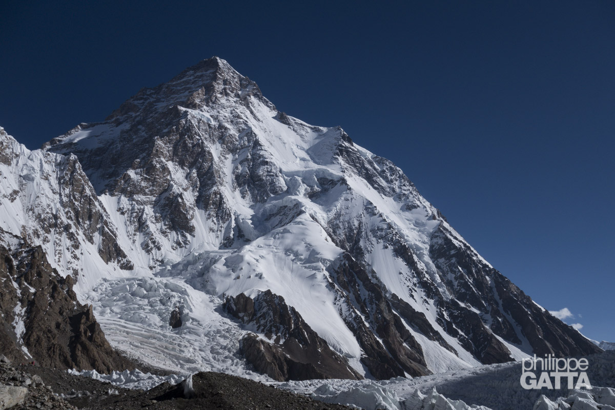
K2 (8,611m)
K2, the world’s second highest peak, is located on the Pakistan-China border in the Karakoram Range. While Mount Everest is higher, K2 is recognized for its technical difficulty among the 8,000m peaks. This reputation is based on its altitude, the specific weather patterns of the Karakoram, and the technical nature of its routes. The pyramid-shaped mountain requires sustained technical climbing and the management of objective hazards such as rockfalls and avalanches.
Italian mountaineers Lino Lacedelli and Achille Compagnoni completed the first ascent of K2 in 1954. This success was supported by Walter Bonatti and Pakistani porter Amir Mehdi, who spent a night in an open bivouac at 8,100m to deliver oxygen bottles for the final summit push.
The most frequent route today is the Abruzzi Spur (South East Ridge). It is named after the Italian explorer Prince Luigi Amedeo, Duke of Abruzzi, who conducted the first attempt in 1909. Although his team reached 6,250m, their expedition provided the mapping that defined the route for future climbers.
Geographically, K2 stands above the Godwin-Austen Glacier. Its local name is Chogori, meaning “The King of Mountains” in Balti, though it was T.G. Montgomerie who designated it “K2” (Karakoram 2) in 1856. Most expeditions access the mountain from the Pakistani side via the Baltoro Glacier, a long approach trek through the range.
The mountain’s history includes several notable expeditions. In 1939, an American team led by Fritz Wiessner reached a point near the summit. The second successful ascent was achieved in 1977 by a Japanese team, ending a 23-year period without a summit.
K2 Historic Timeline
1954
First Ascent
The Italian expedition led by Ardito Desio successfully completed the first ascent of K2. Achille Compagnoni and Lino Lacedelli reached the summit via the Abruzzi Spur.
1977
The Massive Japanese Ascent
A colossal Japanese expedition (including 1,500 porters) achieved the mountain’s second ascent, 23 years after the Italians, confirming the extreme challenge of this peak.
1978
First Ascent Without Oxygen
American climber Louis Reichardt became the first to summit without supplemental oxygen, proving it was physiologically possible even on the “Savage Mountain.”
1986
The Polish Line & Black Summer
Jerzy Kukuczka and Tadeusz Piotrowski established the “Polish Line” on the South Face, a route so dangerous it has never been repeated. That same year, 13 climbers tragically lost their lives during severe storms.
1986
Speed Record
French alpinist Benoît Chamoux completed the ascent via the Abruzzi Spur in a remarkable 23 hours.
2004
The Magic Line
Considered the most technical route on the mountain, the South-Southwest Pillar was successfully climbed by a Catalan team led by Jordi Corominas.
2018
First Full Ski Descent
Polish ski mountaineer Andrzej Bargiel made history by completing the first full ski descent from the summit to base camp without ever removing his skis.
2021
First Winter Ascent
A team of Nepali climbers, led by Nirmal Purja and Mingma G, successfully summited K2 in winter for the first time.
The Expedition
The Team & Logistics
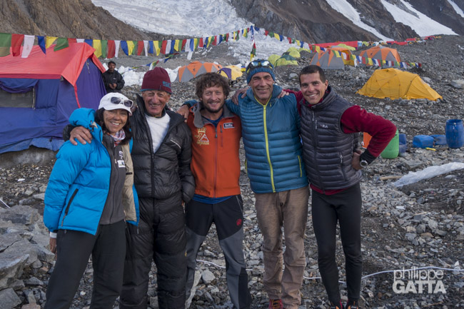
We were seven independent climbers sharing the same climbing permit and logistics. Although we came from different backgrounds, each of us had completed numerous expeditions and summited several 8,000-meter peaks prior to this attempt. We did not know each other before the expedition, but we quickly formed a good team. For my part, I primarily climbed with Noel. We shared many hours on the mountain, and it was with great sadness that I learned of his passing on Annapurna several years later.
There were numerous other teams on the mountain that year, reflecting the growing popularity of K2. While I encountered several mountaineers I had crossed paths with on other peaks in the past, there were two in particular I was very happy to see again: Mike Horn and Fred Roux.
They were there with Kobi Reichen for their third attempt on K2, this time opting for the Cesen route. I had not seen them since our expedition on Makalu, and it was clear they had lost none of their signature energy and motivation.
From Islamabad to Skardu along the Karakoram Highway
The expedition began with the administrative process in Islamabad. Obtaining the climbing permit for K2 took longer than expected, and we had to wait in the capital before receiving the authorization to proceed with our ascent.
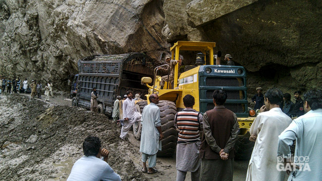
While flights between Islamabad and Skardu are scheduled, they are frequently cancelled due to weather conditions. We therefore traveled via the Karakoram Highway (KKH). The road is often affected by landslides and rockfalls, requiring careful navigation. We also passed through regions where security measures were strictly enforced (area under Taliban control).
We left Islamabad in a convoy of four buses, traveling alongside the Broad Peak expedition team. This collective approach is standard for the region.
The first stage of the journey was consistent, though temperatures reached 35°C and the buses lacked air conditioning. It took approximately 7 to 8 hours to reach Besham. Road conditions were stable, and we noted a significant increase in security compared to our preveious expedition on Gasherbrum. Military personnel were present to secure the hotel where we stayed overnight.
From Besham to Skardu
We departed early in the morning on the 28th, under the protection of the military. Two jeeps with armed guards flanked our bus, and there was even a man carrying a Kalashnikov on board with us. However, unlike before, I did not feel as though my safety was in jeopardy. The road itself has improved significantly, with many new paved sections and ongoing construction projects, all funded by the Chinese.
Despite the improvements, the road remains perilous due to its location in steep gorges. Many sections are vulnerable to rock falls and sheer drops. The stretch of road between Besham and Chilas was particularly challenging. This area is scorching hot, situated at an average altitude of 1,000m and surrounded by brown cliffs and rocks.
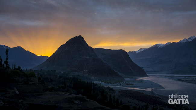
Around midday, the temperature soared to approximately 35-40°C, and we sweltered in the bus. The scenery was somewhat bleak: dry, rocky, and sandy, with the Indus River winding through the valley. The only respite was catching a glimpse of Nanga Parbat in the distance, framed by sand dunes.
After 21 hours of travel by bus, we arrived in Skardu. This long transit preceded the start of our mountain expedition and was a factor in our initial physical preparation.
Trekking to K2 Base Camp
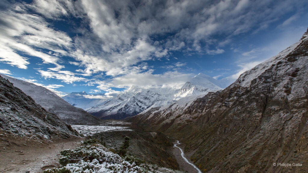
The trek to K2 base camp is probably one of the most beautiful treks in the world. However, it is definitely a tough one. The terrain is rough with several days along the moraine of the Baltoro Glacier. Also, the weather is challenging and can vary from very hot on sunny days, to pouring rain and snowstorms.
However, when the sky is clear, the views over the mountains are stunning: Trango Towers, Masherbrum, Broad Peak, Gasherbrums, K2… Overall, the trek from Askole to K2 base camp is roughly 100 km long with 3,400 meters of elevation gain.
July 1: Skardu - Askole (2,950m)
The drive from Skardu to Askole took 6 hours and went smoothly. One bridge was too damaged to be crossed by the jeeps, so we swapped vehicles on the other side.
Askole is a pleasant small village, the last settlement in the valley.
July 2: Askole - Jhula (3,160m)
The logistics for our expedition were shared with the Broad Peak team, which meant that we had a total of 400 porters at our disposal. We set off at 6am, taking advantage of the cool morning air before the temperature began to rise.
The weather was fantastic, and the views were breathtaking. The trail followed a wide river with sandy banks, flanked by towering hills and snow-capped mountains. Our first stop was at Jhula, a dusty and rather unpleasant campsite, and not the most enjoyable spot on our trek.
Stage: 20 km, +390m/-260m, 3h55.
July 3: Jhula - Paiju (3,450m)
We departed from Jhula at 6 am, an hour after other teams and porters, which made the trail slightly busier. The initial hour was comfortable in the shade, but then the heat returned. However, I maintained a steady pace, overtaking all the porters carrying their impressive 25kg loads. Knowing the route and having a GPS made it easier to manage my effort, and the sandy and dusty terrain reminded me of desert races, making me tempted to run.
During the later part of the day, we caught our first glimpse of K2, the only peak with a plume and high wind at the summit. I arrived at Paiju, located at 3,450m, in 4 hours and 15 minutes, feeling good. Paiju is one of the few places on the trail with trees, providing a break from the scorching sun.
Stage: 20 km, +505m/-290m, 4h10.
July 4: rest day in Paiju (3,450m)
July 5: Paiju - Urdukas (4,050m)
The first hour after Paiju was a breeze, but things quickly became challenging as we began to trek on the Baltoro moraine. The trail was quite rough, with numerous unstable rocks, and required us to traverse ups and downs for 19km while gaining 1,000 meters in elevation. This particular day was likely the toughest of the entire trek to Base Camp.
Despite the difficulties, we eventually arrived at Urdukas camp, which was situated in a picturesque location with breathtaking views of the Trango Tower.
Stage: 19 km, +1000m/-380m, 4h45.
July 6: Urdukas - Goro 2 (4,300m)
We left Urdukas early the next morning to continue our progression on the Baltoro glacier. The terrain was uneven, but clear weather provided constant visibility of Gasherbrum IV and Masherbrum throughout the day.
We reached Goro 2 at 4,300m, located in the central section of the glacier. We established our campsite there and organized our equipment for the following stage.
Stage details: 12km, +535m/-305m, 3h10.
July 7: Goro 2 - Broad Peak BC (4,700m)
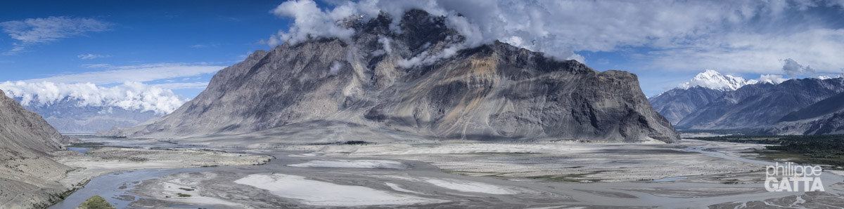
The progression continued under favorable weather, which provided clear views of the surrounding massifs. During this 19km stage, we were surrounded by several major peaks of the Karakoram, including Muztagh Tower, Mitre Peak, Gasherbrums, Broad Peak, and K2. We established our campsite near Broad Peak, on the Godwin-Austen Glacier.
Stage details: 19km, +680m/-250m, 5h.
July 8: Broad Peak BC - K2 BC (5,000m)
Today’s walk was short with the massive face of K2 constantly in front of us. Finally we arrived early and spent the rest of the day setting up our base camp.
Stage: 6 km, +250m/-40m, 1h10
The K2 Ascent
July 9-11: first rotation to K2 camp 1 (6,050m)
After a first round trip to advanced base camp (5,300m), we made our first rotation to camp 1 (6,050m). The objective of the rotations was to get acclimatized to the high altitude and carry all the loads (gear, food, clothes, tent, etc.) to the high camps.
Eventually we reached advanced base camp (ABC) in 2 hours. The 4.5 km walk on Godwin Austin glacier was not too bad and the icefall is relatively short. From ABC, the slope gets steeper (30 to 60 degrees) and with the heavy pack, it took me 3 hours to get to C1.
We spent one cold and windy night there and went back down to base camp (2h30).
July 12-13: rest day at K2 base camp
Time to rest and recover after the first rotation and get ready for the second one.
July 14-17: second rotation up to 6,900m
July 18-23: waiting game at K2 BC
We left Base Camp early in the morning to minimize exposure to rockfalls and avalanches associated with elevated temperatures. I reached Camp 1 in 4h30, supported by improved acclimatization.
The following day, we climbed House’s Chimney and reached Camp 2 in the morning, 3h15 after leaving Camp 1.
We spent a first night at 6,650m. The next day, I climbed to 6,900m on the Black Pyramid before returning to Camp 2 for a second night.
We returned to Base Camp after three days at altitude. The descent involved a 1,700m vertical drop, which took 3h15 from Camp 2. During the descent, we deposited our equipment at Advanced Base Camp.
After returning to Base Camp, we monitored the conditions for a summit push, but the weather remained unfavorable. The heat wave affecting Pakistan, which resulted in 2,000 deaths across the country, also reached the mountain range. This caused a significant rise in temperatures at high altitude.
We used light clothing even at 5,000m, as the freezing level rose to 7,000m. Rockfalls and avalanches occurred daily throughout the period. We also noted running water at an elevation of 6,000m, an unusual occurrence for this environment.
During these conditions, an avalanche on Broad Peak resulted in the death of a porter and injuries to three climbers.
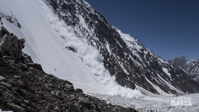
Two massive avalanches destroyed our camps. We lost all our climbing gear and tents.
July 24-26: K2 summit attempt
The stable weather window did not materialize, and forecasts remained inconsistent. A large avalanche descended from 7,000m to the glacier, carrying human remains from previous years. Despite these conditions, we decided to proceed with a summit attempt. Given the short weather window, we chose a direct move from Base Camp to Camp 2, aiming for the summit on the 27th.
However, an avalanche reached our Advanced Base Camp, burying our climbing equipment, including crampons, ice axes, and harnesses. We began searching for the gear using available tools, such as ice axes and kitchen utensils. Although we later received assistance and shovels, the recovery effort was difficult as avalanches continued in the area.
After three days of digging, we recovered only a portion of our equipment. The loss of technical gear and the unfavorable weather forecast resulted in the end of our expedition.
Mike Horn and Fred Roux were also forced to turn back. They had put in an incredible effort, tirelessly breaking trail over and over again, operating alone on the Cesen route.
Ultimately, no team found success, and no one reached the summit of K2 that year. The conditions proved insurmountable for everyone on the mountain.
July 27-Aug 6: trekking back and return to Islamabad
We trekked back to Askole in 4 days and finally reached Islamabad 5 days later, after another epic experience on the Karakoram Highway.
Abruzzi Spur route
The base camp (BC) is located on the Godwin-Austen Glacier at around 5,000 meters. Then, from the BC, the route goes up on the Godwin-Austen Glacier, crosses a short icefall to reach the base of the Southeast Ridge. The advanced base camp (ABC) is set at 5,300m (4.5 km from BC). This camp is more a gear depot than a real camp.
The Abruzzi Spur starts above ABC and climbs a 45° to 65° slope up to Camp 1. Camp 1 is set on a small rocky ridge at 6,050m which is exposed to rock falls and avalanches. Generally, it takes around 4.5 hours from BC to C1.
Higher, the route continues through snow slopes and rock
Above C2
Afterwards, some snow slopes and ridges lead to the first hard section of the route: the 400m of the Black Pyramid. It consists of steep mixed terrain with some vertical cliffs. Camp 3 is set just above the Black Pyramid at 7,400m. The spot is a bit larger than C1 and C2 but it is very exposed to avalanches.
From C3, the route is mainly a 30-40° snow slope leading up to the Shoulder (prone to avalanches). The Shoulder is a wide, low-angle part of the ridge starting at 7,700m. There are several places to set Camp 4 on this plateau, the best being around 7,950m. Camp 4 is relatively safe but very exposed to high winds. From there, the slope becomes progressively steeper and ends at the Bottleneck, a narrow and steep 80° couloir underneath a massive serac.
Finally, at the top of the Bottleneck, the route traverses to the left (55° slope). Soon after this traverse, the route continues more or less straight up to the summit.
K2 summit, 8611
Camp 4, 7950 m
Camp 3, 7400 m
C2, 6700 m
Black Pyramid
Base camp, 5000 m
C1, 6050 m
Bottleneck, 8200 m
Useful Resources