Makalu (8,485m)
Makalu is a mountain of the Himalaya range, located in the remote Makalu-Barun National Park. It sits just 19 km southeast of Mount Everest, on the border between Nepal and China (Tibet). With an elevation of 8,485m, Makalu is the fifth highest mountain in the world and one of the fourteen peaks exceeding 8,000 meters.
Its name is derived from the Sanskrit Maha Kala, a name for the Hindu deity Shiva that translates to “Big Black.” This description fits the mountain perfectly, as it is an isolated peak shaped like a perfect four-sided pyramid. Its distinct shape and sharp ridges make it easily identifiable from far away.
The Historic First Ascent
Makalu was first climbed by a French expedition led by Jean Franco on May 15, 1955. Lionel Terray and Jean Couzy were the first to reach the top. The rest of the climbing team—Franco, Magnone, Bouvier, Coupe, Leroux, Vialatte, and Sardar Gyaltsen Norbu—all summited over the following two days. It was the first time an entire expedition team reached the peak of an 8,000m.
Notable French Achievements & Alpine History
Makalu has a strong connection with French alpinism. Beyond the first ascent, there are several other notable French achievements. Yannick Seigneur and Bernard Mellet successfully climbed the technically demanding West Pillar in 1971.
he 1980s marked a shift toward speed and style. In 1988, Marc Batard climbed the West Buttress solo in just 18 hours. The following year, Pierre Beghin completed a solo ascent of the Yugoslav route on the South Face.
However, the mountain also holds tragic memories. In January 2006, French mountaineer Jean-Christophe Lafaille disappeared near the summit while attempting to make the first winter ascent solo. He left his high camp for the top and was never seen again.
Makalu Historic Timeline
1954
American Attempt
A California team led by William Siri attempted the South East Ridge. They turned back at 7,100m but identified the route that the French would use a year later.
1955
The First Ascent
A French team led by Jean Franco successfully placed nine climbers on the summit over three days. This historic success established the “French Route” as the classic line.
1970
South East Ridge
A Japanese expedition completed the second ascent of the mountain, confirming the difficulty of the route.
1971
The West Pillar
Yannick Seigneur and Bernard Mellet successfully climbed the technically demanding West Pillar, one of the most aesthetic and difficult lines on the mountain.
1986
Reinhold Messner
The mountaineer reached the summit without supplementary oxygen, marking his 12th 8,000m peak in his quest to climb all fourteen.
1988
The Solo Speed Ascent
The climber Marc Batard climbed the West Buttress solo in just 18 hours.
1997
Russian West Face
A Russian team forged a new, direct route up the sheer West Face.
2006
Skiing the Fifth Giant
Extreme skiers began pushing the limits on Makalu’s steep slopes, with several teams attempting the first full descent, marking the mountain’s entry into the modern era of big mountain skiing.
2009
First Winter Ascent
After many failed attempts by various teams, Simone Moro and Denis Urubko finally conquered Makalu in winter on February 9, 2009.
The Expedition
I was happy to team up with Pasang Gombu again. We had previously climbed Everest together and ran sections of the Great Himalaya Trail with Anna.
A highlight of this expedition was meeting Mike Horn and Fred Roux, whom I later had the pleasure of reuniting with during the K2 expedition. Beyond their exceptional mountaineering achievements, both Mike and Fred were inexhaustible sources of high spirits, energy, and motivation. Their presence added a unique dynamic to the team, providing a constant drive in the high-altitude environment.
We left Kathmandu and trekked to the Makalu base camp. This site, also known as Hillary base camp, is located at 4,850m on the Barun Glacier. This camp is primarily used during the trek; for the expedition itself, we established an advanced base camp (ABC) at 5,720m.
We ascended via the French Route (Normal Route), starting on the west side of Makalu. From there, we climbed to Makalu La, a pass at 7,400m, before heading south to the French Couloir at the bottom of the North Face. The ascent concludes on the Northeast Ridge.
It took 37 days to reach the summit before returning to Kathmandu. The entire expedition lasted 56 days.
Trekking to Makalu BC
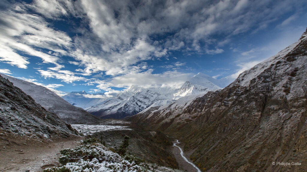
The trek to base camp (BC) of Makalu crosses the Makalu Barun National Park. Actually, this region is more remote and wilder than the famous regions of Khumbu, Annapurnas or Manaslu. In many ways, it is very similar to the Kangchenjunga region.
April 4: Katmandu - Num (1,510m)
We flew from Kathmandu to Tumlingtar and then took a jeep to the village of Num at 1,510m, where we stayed in a rudimentary lodge.
April 5: Num - Seduwa (1,550m)
We started our trek at Num.. From there, we went down to the river at 800 m and then walked all the way up to Seduwa in the heat and humidity.
Stage: 5.5 km, +820m/-775m, 2h45
April 6: Seduwa - Tashigaon (2,110m)
The second day of trekking to Tashigaon was also cloudy, very hot and humid. Tashigaon is the last village of the valley and is probably the nicest one as well. There were several lodges but all were far from being as comfortable as the ones in the Khumbu or Manaslu regions.
Stage: 8.5 km, +690m/-150m, 2h35.
April 7: Tashigaon - Khongma (3,560m)
Once again the scenery of this stage was very similar from what we saw in the Kangchenjunga with the same type of trees, moss and Rhododendrons. The trail above Tashigaon was steep and we quickly reached the snow as we gained altitude. We spent most of the time on a ridge but unfortunately surrounded by clouds. There was only one rudimentary lodge in Khongma.
Stage: 6 km, +1435m/-70m, 3h40.
April 8: Khongma - Dobate (3,850m)
We were looking forward to this stage which crosses three passes over 4,000 m, normally offering great views of Makalu and surrounding mountains. Unfortunately it was once again very cloudy and we crossed the Ghungru La (4,055m), the Shipton La (4,220m) and Keke La (4,152m) all in the snow. Then we descended after the last pass and reached the only lodge of Dobate which was not even on the map. Dobate was again a very basic lodge.
Stage: 8 km, +840m/-615m, 3h45.
April 9: Dobate - Yangle Kharka (3,640m)
This time, we started the day under a clear sky and could see the high mountains for the first time since the beginning of the trek. Below Dobate the trail continues to descend in a steep forest of Rhododendrons. Then it goes down to 3,250m and then goes back up along the nice Barun Nadi (river) up to Yangle Kharka. Yangle Kharka is really a nice place (a Kharka is a grazing pastures for Yaks). There are a few lodges along the river and surrounded by mountains.
Stage: 9.5 km, +400m/-630m, 3h10
April 10: Yangle Kharka - Tumaka (4,015m)
It was a short day to Tumaka, the last open lodge before the base camp. In fact it was more four basic walls and a roof than a lodge but the place is very nice and surrounded by nice cliffs and icefalls. Like all the lodges of the valley, Tumaka did not have any stove, so to warm up and cook they burned tons of wood and we already could see the deforestation around…
Stage: 5.5 km, +345m/-10m, 1h30.
April 11: Tumaka - Hillary base camp (4,850m)
We left the last trees just above Tumaka and progressively entered into a mineral world. The peaks around us were higher, all above 6,000 meters of altitude. Most of them were steep, technical and their faces were often higher than 2,000m high. Then we reached the Barun glacier at 4,600m but the trail remained very good up to the Hillary base camp. This camp is located on flat area and offers a great view over the South face of Makalu.
Stage: 11 km, +915m/-140m, 4h.
April 12 and 13: acclimatization around Hillary base camp (4,850m)
We spent two days to rest and walk around the Hillary base camp. In fact this place is too far away from Makalu to be used as real base camp. So climbers usually spend a few days there to acclimatize before going to the advanced base camp (ABC) where they stay until the end of the expedition.
Hike: 4 km, +300m/-300m, 1h40.
April 14: Hillary base camp - Advanced Base Camp (5,720m)
We left the Hillary base camp early in the morning. The trail was very good up to 5,000m, then it went in the middle of the Barun moraine. Fortunately we could enjoy the view of the South faces of Lhotse and Everest in front of us. Half way through ABC the trail goes to the right, very close to the bottom of rock faces coming from the West pillar. Finally we reached the advanced base camp (ABC) at 5,720m, our home for the following weeks.
Stage: 9 km, +1000m/-155m, 5h.
The 37 days of ascent
April 15: rest day at Advanced Base Camp (5,720m)
At 5,720m, this camp is very high, probably one of the highest of all 14 8000m peaks. Going from BC to ABC and climbing 1,000 m in one day is not ideal. So we spent the day resting and organizing our tent for the next 35+ days.
April 16: ABC - Crampons point (5,950m) - ABC
We made our first small acclimatization hike above ABC. Basically we followed the moraine up to the beginning of the glacier that is called Crampons point (5,950m). Here, we put up a tent to leave boots, crampons, harness that we used from that point on. Then we went back down to the ABC.
Hike: +300m/-300m, 2h. Oxygen saturation: 83%.
April 17: rest day at ABC (5,720m)
Rest day at ABC.
April 18: ABC - Camp 1 (6,420m)
Feeling good, we left the ABC for our first rotation with a double objective: carrying gear to the higher camps and continuing our acclimatization by going higher up. The route is pretty easy and straight forward. It was a bit late when we started so it was extremely hot when we reached the headwall at 6,250m. About an hour and half later, we reached the location of the camp 1 at 6,420m. The clouds came in, along with a cold wind as we put up our tent.
Climb: +740m/-25m, 3h45.
April 19: C1 - C2 (6,650m) - C1
As the C2 was just 230m higher, we thought that was not worth moving the tent down and our gear to gain just 230m. As we still wanted to see the route above, we went up to C2 and came back to the C1 the same day.
Climb: +230m/-230m, 1h05.
April 20: C1 - ABC
We went back down to ABC.
April 21 - May 9
Over 18 days, we made several rotations to Makalu La and Camp 3 (7,470m) to complete our acclimatization and carry gear and supplies to the high camps.
We then descended to the advanced base camp to recover and wait for a favorable weather window. We received daily updates from Anna and Jamie, who eventually gave us the green light. While the general forecast was good, some uncertainty remained regarding the jet stream, which continued to blow hard across the summit.
Pasang and I decided to move up, prepared to wait for better conditions in the high camps if necessary.
May 10: ABC – Crampons Point (5,950m) – ABC
The weather forecast improved slightly, predicting a decrease in wind over the coming days. I decided to exercise again and made another rotation to Crampons Point.
Hike: +300m/-300m, 1h10. Oxygen saturation: 86%.
May 11-12: Rest days at ABC
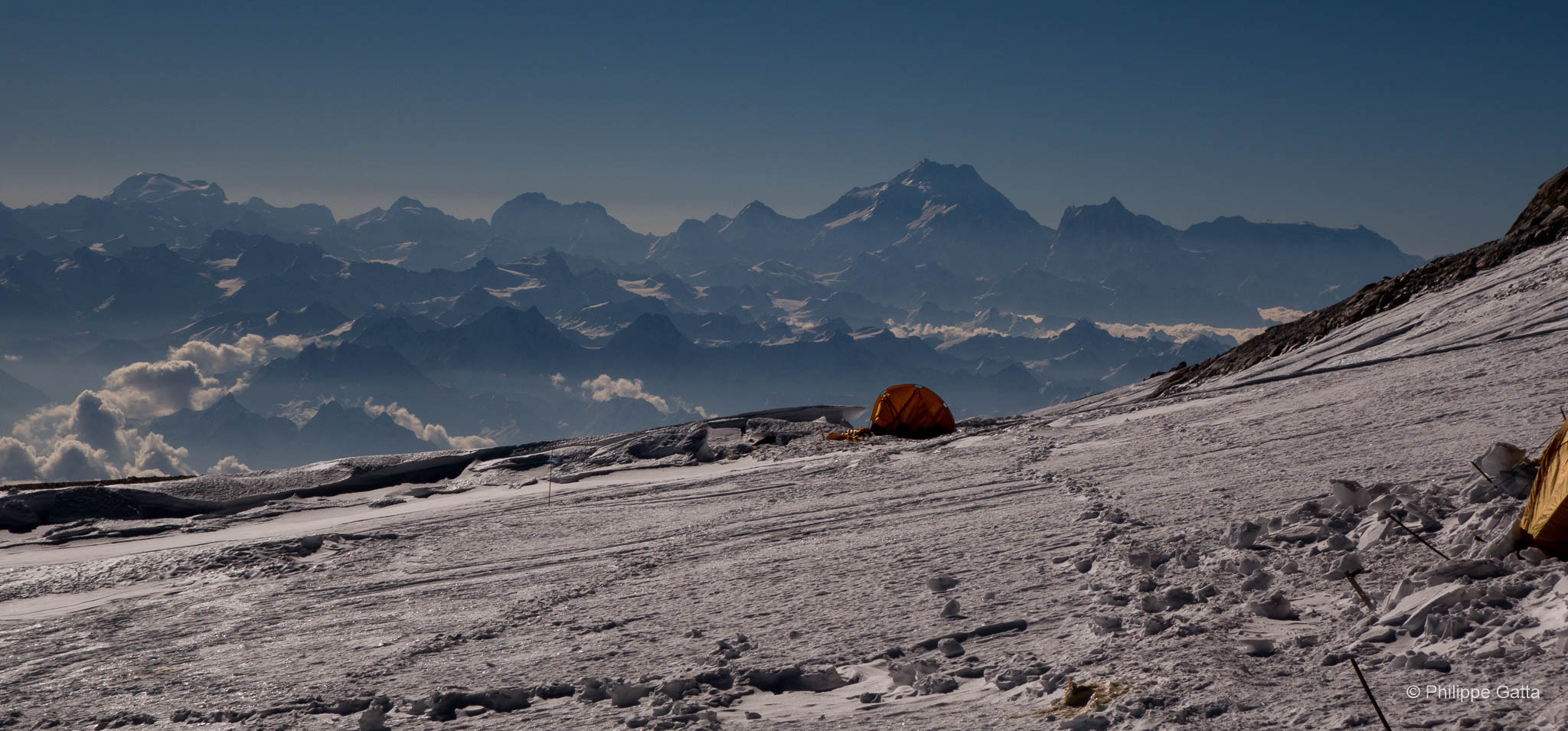
A favorable weather window was confirmed for the 16th. We decided to ascend the following day, climbing straight to Camp 2, where we planned to spend two days before moving to Camp 3 and Camp 4. After some hesitation, we decided to establish a Camp 4 because the 3 km distance and 1,000m elevation gain from Camp 3 to the summit is a significant distance at this altitude.
Departure for the summit bid
May 13: ABC - C2 (6,650m)
The weather window was confirmed for the 16th, though conditions remained quite unstable and windy. We set off for the summit, hoping to reach the peak three days later.
Mike Horn and Fred Roux had already departed the previous day, while the few other climbers on the mountain decided to wait one more day.
We climbed to Camp 2 for the fourth time. All our gear was already staged at Camp 2 and Camp 3, but we brought additional food in case we were forced to change our plans and wait longer.
May 14: Rest at Camp 2
As planned, we spent this day at Camp 2, resting before the demanding climb to Camp 3.
Climb: +950m / -45m, 3h50.
May 15: C2 - C3 (7,470m)
Once again, we left Camp 2 early, knowing the day would be long. It was windy and very cold. The route was steep, especially the first rock band. The ascent is demanding whether fixed ropes are used or not. The weather deteriorated as we climbed the second rock band, and we reached Camp 3 during a blizzard. We pitched the tent, ate quickly, and crawled into our sleeping bags. Meanwhile, the weather forecast worsened, forcing us to postpone our summit push by one day.
Climb: +950m / -0m, 7h10.
May 16: Stuck at Camp 3 (7,470m)
The conditions worsened, with winds reaching 70 km/h throughout the night; five tents were destroyed. We wore our down suits inside our sleeping bags and kept our gear packed in case our tent was destroyed. With the forecast predicting calmer conditions for the following days, we spent the day at Camp 3.
We were concerned about Mike Horn and Fred Roux, who were ahead of us and already at Camp 4.
May 17: C3 - C4 (7,570m)
The wind decreased, allowing us to move up to Camp 4. The climb was even shorter than expected, taking only 1 hour and 10 minutes. Camp 4 was located in a pleasant spot and was better sheltered than Camp 3.
From our position at Camp 4, we could see Mike Horn and Fred Roux on the ridge. They were no longer climbing together. Fred had been faster; he had reached the summit and was already on his way down. Mike seemed to hesitate; we saw him turn back before the false summit and begin to descend. Then, unexpectedly, he turned around again and pushed toward the summit, which he reached quite late.
Fred stopped at our camp for a break before continuing his descent. Mike arrived a few hours later, exhausted. We provided him with food and water, after which he also decided to continue his descent toward the lower camps.
Climb: +230m / -130m. Time: 1h 10m.
May 17 evening - 18: C4 - Makalu summit (8,463m) - C3
We spent the afternoon resting and planning the climb with the rest of the team. There was no fixed rope on the upper part of the mountain, just a small 6mm rope in the French Couloir and nothing above. However, we knew thanks to Mike and Fred that the conditions were good, with very little black ice between the false summit and the true summit. We took 60m of rope.
At 9pm, we left the C4. We crossed the glacier with the rest of the team and went ahead just the two of us. Then we reached the summit ridge above the French Couloir just at sunrise. We started using O2 at around 8,000m.
Above the French Couloir the route was easier until the false summit. Soon, we climbed the false summit and the final ridge to the true summit in solo, using old fixed ropes now and then.
We reached the summit of Makalu just before 6am, after 9 hours of climb. We enjoyed the view for 15 minutes and started the descent.
We met the rest of the team on the ridge above the French Couloir. on our way down. They all reached the top a bit later.
Three hours later, we were back at C4, we packed everything and continued our descent to C3. Someone ate the food that we left in the tent so we ate some snacks, a couple of bars and slept.
Climb: +1130m/-1230m, 12h10.
May 19: C3 – ABC
We left the camp 3 early in the morning with all our gear, tent, clothes and rubbish.
Later, we made a quick stop in camp 2 to gather the food we left there and continued our descent to ABC. It was amazing to see how the mountain had changed since we started our ascent a week before. Particurlaly, most of the snow had melted below 6,200 m.
Climb: +25m/-1775m, 3h15.
May 21: ABC – Hillary BC
We trekked from ABC to the Hillary BC. The snow had melted, all the slopes above the Barun glacier were dry, causing many rock falls.
Stage: 9 km, +155m/-1000m, 3h.
May 22: return to Katmandu
We safely returned to Katmandu.
Information
The French Route
From the ABC, the route follows a moraine up to crampons point at 5,950m. Then it goes on the gentle slopes of the glacier to the bottom of a first headwall at 6,250m where it is possible to set a low camp 1. Climb the headwall to a plateau at 6,370m where it is also possible to set the camp 1. Pass a small serac to the location of the high camp 1 at 6,450m.
Camp 1 - Camp 2
From the camp 1, climb a short steep slope, cross under a serac and climb another slope to a plateau at 6,650m. There is a good spot for a camp 2 there, wide enough for a large number of tents.
Camp 2 – Camp 3
From camp 2, you’ll proceed to climb the gentle snow slopes above, moving South to the base of the two rock bands that originate from Makalu La. The first rock band’s base is situated at 7,000m, where you’ll climb the steep rocks for 150m, moving up to the middle snow slope for around 200m at 40°, situated between the two rock bands. Next, you’ll climb the second rock band, which is less steep than the first but higher. You’ll exit on the right of the actual Makalu La and continue on the snow slope until you reach a large plateau, where camp 3 can be set up at around 7,470m. This plateau is vast and flat, but very exposed to Westerly winds.
Camp 3 – Camp 4
Afterwards, from camp 3, you’ll continue your journey on the plateau towards the Southwest, climb a small wall of mixed terrain, and continue to the rocks at 7,570m to set up camp 4. The distance between camps 3 and 4 is about 1km and +100m, so some climbers may skip camp 4 and start their summit bid from camp 3.
Camp 4 – Summit
Eventually, from camp 4, climb almost straight on the glacier up to 7,770m. Cross the seracs to reach the other side of the glacier. Next, climb on the glacier almost straight again up to 8,200m, then traverse to reach the bottom of the French Couloir. Climb the left side of the French Couloir, which mainly involves a rock and mixed climb with four short (2m) but harder sections. The end of the Couloir is less steep and becomes more snowy. Reach the snow ridge at 8,400m and follow it, which is relatively large and easy until the base of the false summit. Climb the false summit on the right, which is short but steep and exposed. Traverse from the false to the true summit, avoiding the cornice. Again the climb is short but exposed. Finally, reach the tiny summit at 8,485m.