Gasherbrum II (8,035m)
The Shining Mountains: An Introduction to the Gasherbrum Massif
Situated in northwestern Pakistan, at the borders of Pakistan, India, and China, the Gasherbrum massif boasts the highest concentration of giant peaks on Earth. The Karakoram is a vertical wilderness of unparalleled scale, home to four of the world’s fourteen 8,000-meter peaks: K2 (8,611m), Broad Peak (8,047m), Gasherbrum I, and Gasherbrum II.
The name “Gasherbrum” translates from the Balti language as “Shining Wall.” Gasherbrum I, also known as K5 or Hidden Peak, is the highest of the group at 8,068 meters. It is the 11th highest mountain in the world and remains one of the least frequented 8,000-meter peaks. Since the first ascent on July 5, 1958, by Nicholas B. Clinch, Pete Schoening, and Andy Kauffman, only 265 climbers have reached its summit.
Climbing Gasherbrum I is a formidable challenge. The most common route via the Japanese Couloir is more technical and demanding than those on Gasherbrum II or Broad Peak. While Base Camp (5,150m) and Camp 1 (5,950m) are shared, the path to the summit of “G1” requires establishing Camp 2 at 6,250m and Camp 3 at 7,200m.
Standing nearby is Gasherbrum II (formerly K4), the world’s 13th highest mountain at 8,035 meters. First climbed on July 8, 1956, by Austrians Fritz Moravec, Josef Larch, and Hans Willenpart, it has seen 871 successful summits. The normal route follows the Southwest Ridge, with high camps established at 6,450m (C2) and 7,000m (C3).
Gasherbrum I Historic Timeline
William Martin Conway, a British explorer, gave Gasherbrum I the name “Hidden Peak” because of its extreme remoteness, hidden behind the massive ridges of the Baltoro glacier’s surrounding giants.
A large international expedition led by Swiss explorer Günther Dyhrenfurth reached 6,300 meters on the mountain. This was the first time the massif was explored for climbing purposes.
On July 5, Americans Pete Schoening and Andy Kauffman reached the summit for the first time via the Roch Ridge. This remains the only 8,000-meter peak whose first ascent was achieved by an American team.
Reinhold Messner and Peter Habeler made history by climbing the Northwest Face in pure alpine style (no fixed ropes, no high camps, no supplemental oxygen). This ascent fundamentally changed the philosophy of high-altitude mountaineering.
French climber Marie-José Valençot became the first woman to reach the summit. During the same year, a new route was opened on the North Face by a German team.
Reinhold Messner and Hans Kammerlander achieved the first-ever traverse of two 8,000m peaks (Gasherbrum I and Gasherbrum II) without returning to base camp, a feat that took them eight days.
Adam Bielecki and Janusz Gołąb (Poland) reached the summit on March 9, marking the first successful winter ascent of Hidden Peak, enduring temperatures below -40°C.
Gasherbrum II Historic Timeline
First Ascent
On July 8, an Austrian expedition led by Fritz Moravec, along with Josef Larch and Hans Willenpart, made the first successful ascent via the Southwest Ridge, which remains the normal route today.
The First Female Ascent
A Polish women’s expedition made history when Halina Krüger-Syrokomska and Anna Okopińska reached the summit, marking the first time a women’s team successfully climbed an 8,000m peak independently.
The Legendary Traverse
Reinhold Messner and Hans Kammerlander completed the first-ever traverse of two 8,000m peaks. They climbed Gasherbrum II followed by Gasherbrum I in one continuous push, without returning to Base Camp.
The South Face New Route
A Russian team opened a difficult new route on the steep South Face. This ascent demonstrated that Gasherbrum II, though often considered “accessible,” possesses extremely technical faces.
The Speed Record
Denis Urubko established a breathtaking speed record, climbing from Advanced Base Camp (5,800m) to the summit in just 7 hours and 30 minutes, showcasing the peak’s potential for high-speed alpinism.
First Winter Ascent
Simone Moro, Denis Urubko, and Cory Richards achieved the first winter ascent on February 2. This was the first winter success on an 8,000m peak in the Karakoram, a feat previously thought impossible.
Ski Descent from the Summit
Several teams have attempted ski descents, but 2019 saw a resurgence in interest for high-altitude skiing on G2’s slopes, confirming its status as one of the best 8,000m peaks for extreme skiing.
The Expedition
The Team
I teamed up with Gorgan Wildberger and Serap Jangbu Sherpa. At the time, Serap was on the verge of a historic achievement; he had only Gasherbrum I, Broad Peak, and Nanga Parbat left to complete the prestigious list of the world’s fourteen 8,000-meter peaks. Anna and Cassidy remained with us until we reached Base Camp at 5,150m, at which point they began their return journey.
To optimize our logistics, Gorgan, Serap, and I shared base camp services with the Altitude Junkies team and ATP (Adventure Tour Pakistan).
Geopolitical Context & The Karakoram Highway
When we undertook this expedition, the geopolitical situation in the region was highly complex. There was a significant Taliban presence only a few kilometers from the Karakoram Highway (KKH), which made the journey to the mountains a high-risk operation.
The transfer to Skardu was extremely tense. We were escorted by armed military personnel and were strictly prohibited from leaving our vehicles during the journey. For security, we spent our nights in protected military barracks rather than public hotels. Crossing the numerous military checkpoints added another layer of stress, as the soldiers themselves appeared visibly nervous.
It was only upon reaching the isolation of Base Camp that the atmosphere finally settled. However, the sense of relief was temporary, as the return journey to Islamabad at the end of the expedition proved to be just as tense and heavily guarded.
Trekking to Gasherbrum BC
The team arrived in Islamabad on June 6th. As the flight from Islamabad to Skardu was canceled several times due to weather, we eventually had to travel by road along the legendary Karakoram Highway. This 28-hour bus ride was grueling and rough, but we finally reached Skardu on June 10th.
A few days later, we reached Askole (2,950m) after a bumpy 7-hour Jeep journey from Skardu (120 km), the last outpost of civilization before entering the high wilderness. On June 13, we officially began the long trek from Askole toward the Gasherbrum Base Camp.
Askole (2,950m) - Jhula (3,100m)
Overall, the trail was well-defined, leaving the grassy meadows of Askole to follow a sandy path along the river. Under the direct sun, the heat was intense and the environment felt like a high-altitude desert. It was a long, dusty march to start our journey into the Karakoram.
Distance: ~20 km. Time: 5h45.
Elevations: +430 m / -330 m.
Jhula - Paiju (3,450m)
We spent another day on the sandy trail, continuing to follow the river valley. Paiju was a pleasant campsite, famously known for its few precious trees—the last greenery we would see for weeks. It offered stunning views over the Nameless Tower (located east of the Trango Towers).
We then spent a necessary rest day at Paiju to allow our porters to prepare their supplies and for our bodies to begin adjusting to the altitude before stepping onto the glacier.
Distance: ~21 km. Time: 5h30.
Elevations: +430 m / -190 m.
Paiju - Urdukas (4,050m)
After leaving Paiju, the trail continued for about an hour before we finally stepped onto the massive Baltoro Glacier. From that point forward, the journey was 100% on the glacial moraine. The terrain was rough and demanding, constantly zigzagging and navigating relentless ups and downs over the rock-covered ice.
Urdukas was perched on the slopes above the glacier on the southern side. It was a spectacular site, offering a final patch of grass and truly outstanding views across the valley toward the granite spires of the Trango Towers.
Distance: ~19 km. Time: 6h45.
Elevations: +1,000 m / -390 m.
Urdukas - Goro II (4,300m)
After leaving Urdukas, the route moved toward the center of the Baltoro Glacier. When the weather cleared, we were rewarded with a staggering panorama of the world’s most iconic peaks: Masherbrum, Muztagh Tower, Gasherbrum IV, and Broad Peak. The Goro II campsite was situated directly on the ice of the glacier.
It snowed heavily during the night, and the porters refused to continue in those conditions, forcing us to spend an unplanned second night at Goro II. These delays are a common part of the logistical challenges in the Karakoram wilderness.
Distance: ~14 km. Time: 4h35.
Elevations: +510 m / -215 m.
Goro II - Shagring (4,750m)
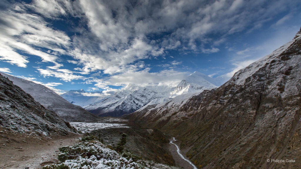
From Goro II, the trail continued along the center of the glacier until we reached Concordia. This legendary site is the magnificent junction of several massive glaciers: the Baltoro, Abruzzi, Godwin-Austen, and Vigne. The panorama from Concordia was breathtaking and is widely considered one of the most spectacular in the world. From this single vantage point, we could see two 8,000-meter giants—K2 and Broad Peak—surrounded by a sea of countless peaks exceeding 6,000 meters.
We decided to push further to camp at Shagring, which was much cleaner and quieter than the main Concordia site. This junction is the geographical heart of the Karakoram: to the north, the trek toward K2 and Broad Peak follows the Godwin-Austen Glacier; to the southwest, the route to the Gondogoro Pass crosses the Vigne Glacier; and for us, our path to the Gasherbrums headed southeast onto the upper Baltoro Glacier.
Distance: ~19 km. Time: 7h total (including 3h30 to reach Concordia).
Elevations: +760 m / -340 m.
Shagring - Gasherbrum BC (5,150m)
The final leg of the journey to the Gasherbrum Base Camp was relatively short, following the junction of the Baltoro and Abruzzi glaciers. Throughout the walk, we were surrounded by a theater of giants, with outstanding views over the Gasherbrum massifs, the elegant snow-domed Chogolisa, Mitra Peak, and Baltoro Kangri.
We finally established our base camp on the central moraine of the Abruzzi Glacier, positioned strategically just below the chaotic entrance of the icefall that leads toward Gasherbrum I. This would be our home for the weeks to come, a world of rock and ice at the foot of the 8,000-meter giants.
Distance: ~11 km. Time: 3h30.
Elevations: +500 m / -210 m.
The Ascent
June 23
Anna and Cassidy departed base camp. They had been hoping to exit via the Gondogoro La, but the pass remained closed due to the heavy snowfall the area had recently received. Instead, they were forced to take the long way out.
They finally reached Islamabad after an epic trek back down the Baltoro glacier, followed by a harrowing road trip marked by the fear of recent attacks along the Karakoram Highway. In the 2009 context, the security situation added a significant layer of stress to an already grueling journey.
June 23 - June 28
Over a period of five days, we completed several rotations, carrying 20 kg packs, between the Base Camp (5,150m) and Camp 2 (6,450m) to acclimatize and transport gear and supplies to the high camps. The traverse of the Gasherbrum Icefall, located between Base Camp and Camp 1 (5,950m), required navigating a total distance of over 10 km per trip due to the numerous switchbacks and detours necessary to bypass the glacier’s crevasses.
Total Elevation Gain (per rotation): +1,300 m
Average Pack Weight: 20 kg
June 29 - July 3
We continued to carry loads to the higher camps, but progressing above Camp 2 (6,450m) became impossible. Heavy snowfall was constant, triggering regular avalanches across all aspects of the surrounding peaks. Unfortunately, the weather forecast for the coming days remained grim, offering no clear window for further movement.
July 4 - July 11
The weather forecasts were consistently inaccurate; the predicted clear windows were repeatedly delayed, replaced by continuous snowfall and summit winds exceeding 80 km/h. On Gasherbrum II, avalanches occurred daily, leaving the slopes above Camp 2 (6,450m) excessively exposed. Consequently, we decided to shift our objective to Gasherbrum I via the Japanese Couloir.
As this route is steeper and composed primarily of hard ice, it was considered less prone to avalanche accumulation than the snow-loaded slopes of G2. Meanwhile, the team attempting Gasherbrum IV abandoned their expedition, and the neighboring teams on K2 and Broad Peak reported facing the same critical conditions throughout the Karakoram.
July 12 - July 16
We found no further success on Gasherbrum I (8,068m). A relentless pattern repeated itself: two days of heavy snowfall would deposit 50 to 80 cm of fresh powder, followed by clear skies. However, climbing remained impossible during these windows as we had to wait for the snowpack to stabilize, while summit winds frequently exceeded 70 km/h.
Before conditions could improve, the next storm cycle would begin. Facing these insurmountable conditions, several teams abandoned their objectives and decided to begin their trek back to civilization, signaling the end of the season for many in the Karakoram.
July 17 - August 5
For 19 desperate days, a brutal cycle persisted: two to three days of severe weather followed by only two days of sun. During these brief clearings, temperatures rose rapidly, triggering widespread avalanches across all slopes. Each time, the trail was obliterated, and the deep crevasses of the Gasherbrum Icefall became dangerously hidden under fresh, unstable snow.
Tragedy struck the mountain when a climber disappeared on Gasherbrum II (8,035m). Following this, all teams on Gasherbrum IV (7,925m) and Gasherbrum VI (6,979m) abandoned their attempts. With the weather forecast showing no improvement for the following week, we made the final decision to retreat.
We coordinated with the remaining teams for one last rotation to retrieve our high-altitude gear and equipment from the upper camps, bringing everything back down to Base Camp. We are now awaiting the arrival of the porters for the long trek back toward Skardu.
Others 8000m
This year, the conditions across the Karakoram were exceptionally severe. Nobody reached the true summit of Broad Peak (8,051m), and unfortunately, several fatalities were reported on both Broad Peak and K2 (8,611m). On Gasherbrum VI (6,979m), Daniela Teixeira and Paulo Roxo made multiple attempts but were forced to retreat due to unstable snow conditions and constant avalanches.
For similar reasons, the technical objectives on Gasherbrum III (7,946m) and Gasherbrum IV (7,925m) remained out of reach for Don Bowie, David Falt, Bruce Normand, Guy McKinnon, and Billy Peirson. Amidst these challenges, Arian Lemal, who was part of a Gasherbrum I & II expedition, dedicated significant effort to environmental preservation. He worked extensively to collect abandoned rubbish at the Gasherbrum Base Camp (5,150m) and Camp 1 (5,950m), continuing the cleanup mission he had previously initiated on Aconcagua.
Trekking from BC to Gondogoro La and Hushe
We decided to conclude the expedition by trekking toward the Gondogoro La (5,600m) rather than returning via the standard Baltoro route used during our approach. This journey from the Gasherbrum Base Camp (5,150m) to Hushe is one of the most demanding and scenic high-altitude traverses in the Karakoram.
While the scenery was magnificent, the trek proved to be truly epic. The terrain was significantly more exposed and rougher than most high-altitude trekking routes in Nepal. The crossing required navigating complex glacial moraines and the Vigne Glacier before ascending the steep, sustained slopes of the pass.
Reaching the col offered a unique 360-degree panorama of four 8,000-meter giants: K2 (8,611m), Broad Peak (8,051m), Gasherbrum I (8,068m), and Gasherbrum II (8,035m). The subsequent descent into the Hushe Valley marked a dramatic transition from the stark, glaciated world of the high peaks to the first signs of alpine vegetation and traditional Balti settlements.
Gasherbrum BC - Ali Camp (5,050m)
The first part of the trek followed the same route as our approach. Upon reaching the junction where the Baltoro Glacier turns north toward Concordia, we left the central moraine heading toward Shagring and began a westward traverse across the glacier’s main body. We crossed several technical moraines and sections of bare ice before reaching a faint trail on the far western edge of the glacier.
We then descended toward the Vigne Glacier, turning south-east to follow its upward flow along the western side. Navigating the glacier required crossing several glacial rivers; these were particularly tricky and difficult to negotiate as we neared the final approach. We eventually reached Ali Camp (4,800m). The site offered very few level spots for tents and was unfortunately heavily burdened with abandoned rubbish.
Distance: ~19 km. Time: 8h.
Elevations: +400 m / -500 m.
Ali Camp - Gondogoro Pass (5,600m) - Shaisho (3,400m)
After departing Ali Camp (4,800m) at 1:00 AM, we immediately encountered several glacial rivers that required crossing. Despite the heavy snowfall of the season, the route was well-equipped with fixed ropes extending from the base of the Gondogoro La (5,600m) north face, up to the Pass, and down the southern side. On the descent, the typical steep scree slopes were entirely concealed under a thick layer of snow, significantly altering the technical nature of the path.
Following the descent, we stopped for lunch at Huespah, a pleasant site offering a stunning view of the iconic Laila Peak (6,096m). However, a considerable distance remained to be covered. We continued the long march down to Shaisho (3,330m), a campsite situated beside a river and sheltered by the first trees encountered since the beginning of the trek.
Distance: ~28 km. Time: 12h (including 3h45 for the ascent to the Col).
Elevations: +900 m / -2,300 m.
Shaisho - Hushe (3,180m)
The final section of the trail from Shaisho (3,330m) to Hushe (3,050m) was well-maintained and relatively short, marking our final return to inhabited areas. Upon reaching the village of Hushe, we concluded the trekking portion of our expedition.
From Hushe, it took a 6-hour Jeep drive to reach Skardu, navigating the rugged mountain roads that follow the Shyok and Indus rivers. This journey officially closed the loop of our 2009 Karakoram expedition.
Distance: ~10 km. Time: 2h 10m.
Elevations: +50 m / -270 m.
Information
Gasherbrum II (8,035m) – Southwest Ridge
- Base Camp (5,150m): Located on the central moraine of the Abruzzi Glacier.
- Base Camp to Camp 1 (5,950m): Traverse of the Gasherbrum Icefall. This section involves navigating a 10km labyrinth of crevasses and vertical seracs. Terrain consists of shifting glacial ice.
- Camp 1 to Camp 2 (6,450m): Ascent of the “Banana Ridge.” The route follows a steep snow and ice spur with sustained slopes of 40° to 50°. This section requires the use of fixed ropes for approximately 500m of vertical gain.
- Camp 2 to Camp 3 (7,000m): Progression along the upper Southwest Ridge. The terrain becomes a broad, high-altitude plateau. Inclination decreases but the route is fully exposed to north-westerly winds.
- Camp 3 to Summit (8,035m): The final push begins with a long diagonal traverse across the Southwest Face to reach the base of the summit pyramid. The final section consists of a steep snow couloir (approx. 45°) leading directly to the narrow summit ridge.
Gasherbrum I (8,068m) - (Japanese Couloir)
- Base Camp (5,150m): Shared with Gasherbrum II, located on the Abruzzi Glacier moraine.
- Base Camp to Camp 1 (5,950m): Traverse of the Gasherbrum Icefall. Navigates a 10km section of shifting ice, crevasses, and seracs. This stage is common to both G1 and G2 routes.
- Camp 1 to Camp 2 (6,450m): Crossing of the “Gasherbrum Valley” (the high plateau) followed by the approach to the base of the Northwest Face. The terrain is relatively flat glacier travel with significant crevasse risk.
- Camp 2 to Camp 3 (7,100m): Ascent of the Japanese Couloir. This is the technical crux of the route, consisting of a sustained snow and ice couloir with an average inclination of 50° to 55°. It requires approximately 600m of fixed ropes on mixed terrain.
- Camp 3 to Summit (8,068m): The route exits the couloir onto the upper slopes. It involves climbing steep snow fields (40°-45°) and navigating through rock bands to reach the final summit ridge. The final section is highly exposed to wind and altitude.
GPS Coordinates
- Askole: 35°40.978N / 75°49.006E
- Jhula: 35°41.470N / 75°58.464E
- Paiju: 35°40.631N / 76°07.542E
- Urdukas: 35°43.637N / 76°17.072E
- Goro II: 35°44.673N / 76°24.075E
- Concordia: 35°44.551N / 76°30.771E
- Shagring: 35°42.472N / 76°34.136°E
- BC Gasherbrum: 35°41.164 N / 76°39.023 E
- Gasherbrum C1: 35°43.841N / 76°38.859E
- Ali Camp: 35°39.891N / 76°30.739E
- Gondogoro Pass: 35°39.240N / 76°28.265E
- Shaisho: 35°31.020N / 76°24.190E
- Hushe: 35°39.891N / 76°30.739E