The Tour du Mont Blanc
An Alpine Circuit Through Three Nations
The Tour du Mont Blanc (TMB) is a long-distance trekking route across France, Italy, and Switzerland. Circling the Mont Blanc Massif, the route covers approximately 170km (105 miles) and involves 10,000m (32,800 feet) of cumulative elevation gain. Because it circumnavigates the highest peak in Western Europe, the landscape features glaciers, granite spires, and alpine meadows.
Traditionally, hikers complete the full circuit in an anti-clockwise direction over seven to ten days. However, the TMB has seen an increase in popularity among trail runners. While many now cover the loop in three to five days, athletes also participate in the Ultra-Trail du Mont-Blanc (UTMB), finishing the 170km course in less than 21 hours. This guide describes the journey as a four-stage trail running expedition, balancing effort with the topography of the region.
The valleys have numerous mountain huts (refuges) and hotels, allowing runners to customize their daily mileage based on fitness or weather conditions. Multiple gateways exist to start the loop, such as Chamonix, Les Houches, or Les Contamines in France, Courmayeur in Italy, and Champex-Lac in Switzerland.
The TMB consists of a classic route and several official variants. These variants offer different levels of challenge: some cross high passes—like the Fenêtre d’Arpette—placing runners close to the glaciers, while others follow lower trails through the valleys. The route weaves through six major valley systems, including the Valjoie, Vallée des Glaciers, Val Veni, Val Ferret, and the Trient valley. Certain sections of the TMB overlap with the GR5, a footpath that crosses the Alps from Lake Geneva to the Mediterranean. The TMB remains a reference for alpine endurance.
Four Days Around the Massif
We ran the TMB in four days, a pace that allowed for an active pace while providing time to record the trip through photography and video. Rather than sticking strictly to the classic itinerary, we opted for several variants (alternate routes). These higher-altitude paths kept us closer to the glaciers and offered technical terrain compared to the standard valley trails.
Our selected variants included:
- Trient – Col de Balme – Tré-le-Champ: Offering a view into the Chamonix valley.
- La Flégère – Le Brévent – Refuge de Bellachat: A high-balcony traverse with a view of the Mont Blanc range.
- Col de Voza – Col de Tricot – Chalets de Miage – Les Contamines-Montjoie: A section featuring a suspension bridge and a descent into the Miage valley.
While many choose Les Houches as a starting point, we began our loop in Courmayeur, Italy. This was convenient for our logistics and allowed us to tackle the Italian side of the massif first.
Our 4-Stage Itinerary:
- Stage 1: Courmayeur – Champex-Lac
- Crossing the Grand Col Ferret to enter Switzerland.
- Stage 2: Champex-Lac – Refuge de Bellachat
- A demanding day involving the technical terrain of the Aiguilles Rouges.
- Stage 3: Refuge de Bellachat – Refuge du Col de la Croix du Bonhomme
- Traversing through Les Contamines and climbing into the Beaufortain region.
- Stage 4: Refuge du Col de la Croix du Bonhomme – Courmayeur
- The final stage back into Italy via the Col de la Seigne and the Val Veni.
Stage 1: Courmayeur – Champex: 48 km and +2513 m / -2258 m
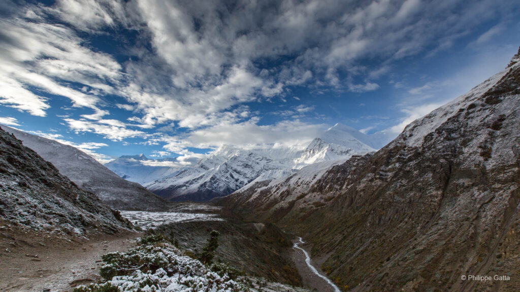
Leaving the center of Courmayeur (1,205m), the journey begins with an ascent toward Refuge Bertone (1,991m), initially following the road before transitioning onto a trail. After Bertone, the terrain becomes a runnable section of the TMB: nearly 10km of relatively flat singletrack. This balcony trail leads to Refuge Bonatti (2,025m), offering a view of the Mont Blanc massif, the Dent du Géant, and the Grandes Jorasses above the Val Ferret.
Continuing northeast from Bonatti, the trail remains flat for approximately 3km before a descent leads to the Chalets Val Ferret (Arp Nuova). This marks the end of the flat terrain and the start of the main climb.
The ascent begins after passing Refuge Elena (2,062m). The route gains 470m of elevation to reach the Grand Col Ferret (2,537m), which marks the border into Switzerland.
From the pass, the route follows a descent of 21km with a drop of 1,400m. The initial descent to Refuge La Peule (2,100m) is on a mountain trail, which transitions into a dirt road. The route passes through the alpine village of Ferret before reaching La Fouly. It then continues through Praz de Fort and Issert, mostly on roads or trails. This section represents the low point of the stage at 1,050m. The final section involves a climb through a forest along the Sentier des Champignons to reach Champex-Lac.
Stage 2: Champex – Col de Balme – Refuge de Bellachat: 45 km and +3216 m / -2559 m
The second day began with a departure from Champex, following the road briefly before rejoining the trail toward La Bovine. This section involved a climb: from the valley floor at 1,300m to the high point at 2,000m, the trail covered 6km, including a steep, rooted section through the forest before opening into alpine pastures.
From the top, a descent led to the Col de la Forclaz (1,526m). Here, the TMB offered two options; we chose to descend to the village of Trient via a fast trail.
From Trient, the ascent began to the Col de Balme (2,191m), marking our return to France. This climb was 4.5km with a 700m vertical gain. After crossing the pass, we opted for the western variant toward the Chalet de Balme followed by a technical descent through the forest to reach Tré-le-Champ.
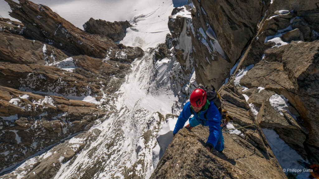
The next section was a technical part of the TMB. From Tré-le-Champ, we climbed toward La Flégère, gaining 700m over 3km. This trail reached its high point below the Lac des Chéserys and included sections with ladders and metal steps. We then descended 3.4km to reach the Flégère station.
While the UTMB route heads down to Chamonix from here, we continued toward Chalet de Planpraz (5.2km, +200m). The final challenge of the day was the 2km climb (+400m) to the summit of Le Brévent (2,421m). From this peak, we followed the TMB/GR5 downhill for 2km to reach the Refuge de Bellachat (2,152m), located across from the Mont Blanc summit.
Stage 3: Refuge de Bellachat – Col du Tricot – Croix du Bonhomme: 41 km and +2752 m / -2465 m
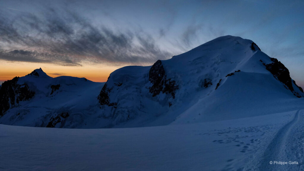
The sunrise over the Chamonix valley and the Mont Blanc massif was visible from the Refuge de Bellachat. The day began with a technical descent to Les Houches: a drop of 1,100m over 7.5km. In Les Houches (1,003m), we rejoined the UTMB route and started the ascent toward Col de Voza (1,653m).
After the pass, we opted for an alternate route toward Col de Tricot (2,120m). This section led from Col de Voza to Bellevue (6km, +750m) on a wide trail before transitioning into singletrack through the forest.
The climb from the Chalet de Tricot to the Col de Tricot was 2km (+415m). At the summit, there was a view of the Aiguille du Goûter and the North Face of Bionnassay. The descent to the Chalets de Miage was short and steep (1.9km, -531m). We then climbed to Chalets du Truc before descending to Les Contamines-Montjoie (1,227m).
From Les Contamines, we began a 12.6km ascent with a 1,320m vertical gain toward Col du Bonhomme. The first section to Notre Dame de la Gorge followed a gentle gradient. Beyond the chapel, the trail steepened as we passed the Nant Borrant and La Balme refuges. The environment became more rocky as we reached Col du Bonhomme (2,329m). A final traverse led to the Refuge du Col de la Croix du Bonhomme (2,433m), located at the junction of the Mont Blanc and Beaufortain massifs.
Stage 4: Refuge de la Croix du Bonhomme – Courmayeur: 35 km and +1452 m / -2610 m
The final day began with a descent. From the Refuge du Col de la Croix du Bonhomme, the trail dropped toward Les Chapieux (1,585m), covering 5km with a vertical loss of 850m. From there, the route toward Italy began.
The ascent to the Col de la Seigne (2,516m) covered 11km with a gain of 965m. The first section to La Ville des Glaciers (1,789m) followed a road through the valley. At the village, the path transitioned to a trail that climbed 707m over the final 5km to reach the pass. Crossing the Col de la Seigne marked the entry into Italy with a view of the southern face of the Mont Blanc massif.
The descent into the Val Veni followed a trail that allowed for a steady pace. We passed the Refuge Elisabetta and continued along a dirt road. After 6.5km and a descent of 540m, the route began a climb toward Chécroui, crossing a pass at 2,420m (3.2km, +440m).
The final leg was a descent from Chécroui to Dolonne, dropping 1,170m over 8km. Once we reached the village of Dolonne, a stretch on the road led back to Courmayeur. This completed the 170km loop through the Alps.
Practical Information
Completing the Tour du Mont Blanc in a trail-running style requires logistics regarding movement through the valleys and adapting to alpine conditions.
Water and Nutrition
One feature of the TMB for runners is the availability of water points. Fountains are located in villages such as Les Contamines, Courmayeur, Champex, and La Fouly, and water is accessible at most refuges. Carrying 1 to 1.5 liters is usually sufficient between resupply points. For nutrition, refuges offer snacks and meals, though they can be spaced several hours apart. It is important to carry enough fuel for the long climbs, such as the efforts toward the Col du Bonhomme or the Grand Col Ferret.
Accommodation
Due to the popularity of the TMB, mountain refuges are often booked in advance. However, there are lodging options in valley towns such as Les Houches, Les Contamines, Courmayeur, and Champex-Lac. These towns offer hotels and gîtes that are often more accessible for bookings than mountain huts.
Weather and Safety
Alpine weather can change quickly. In the event of storm warnings or low visibility, it is advised to avoid high-altitude variants, such as the Fenêtre d’Arpette or the Col de Tricot. Instead, follow the classic TMB route, which stays at lower elevations. Before starting a stage, you should consult La Chamoniarde in Chamonix for updates on trail conditions and weather. Additionally, refuge wardens provide information for their specific sector regarding the state of the passes.
Professional Support
For those who prefer not to manage logistics alone, mountain guides and coaches are available in the region. They offer organized tours and technical support for runners and hikers.