The Atacama Crossing
High Altitude and Harsh Terrain
The Atacama Crossing is a 250km (155 miles) multi-stage footrace set in the Atacama Desert, centered around San Pedro de Atacama, Chile. This event follows the RacingThePlanet format: six stages over seven days, consisting of four consecutive marathons, followed by a 74km “Long March,” a rest day, and a final 11km sprint to the finish.
Following self-supported principles common to the Marathon des Sables, Gobi, or Sahara races, competitors are responsible for carrying their entire kit. This includes clothing, sleeping gear, mandatory safety equipment, and seven days of food. The organizers provide only water (10 to 13 liters daily) and shared tents. The logistical challenge is significant: fitting all equipment into a racing pack while keeping the total weight—excluding water—below 9kg requires planning.
The Atacama Crossing is considered a challenging part of the 4 Deserts Series due to environmental factors. During the day, temperatures can reach 46°C (a peak recorded during the long stage), while nighttime temperatures often drop to 6°C. These nights are colder than those in the Sahara, requiring warmer clothing and a suitable sleeping bag. Furthermore, the ground at the campsites is often rocky, making a sleeping mattress necessary.
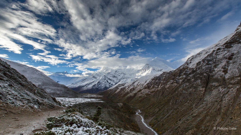
A distinct challenge of this race is the altitude. The course takes place at an average elevation between 2,400m and 3,500m. This thinner air impacts recovery and physical performance differently than sea-level deserts.
I ran the race with Anna. Partnering for a 250km self-supported journey added a layer of shared strategy and mutual support to the endeavor. We prepared for the salt flats, the canyons, and the high-altitude plateaus of this region.
Race Quick-Look:
- Total Distance: 250km / 6 Stages
- Location: San Pedro de Atacama, Chile
- Elevation: 2,400m to 3,500m
- Climate: Daytime peaks of 46°C; nighttime lows of 6°C
The Atacama Crossing: Route and Logistics
The event spans ten days in total. Competitors are required to arrive in San Pedro de Atacama at least two days prior to the start to acclimate to the altitude. The Saturday before the race is dedicated to the mandatory briefing, equipment review, and medical check-in, followed by a transfer to the first camp.
The course covers 230km with a cumulative elevation gain of 1,510m and a loss of 2,210m. The route remains at high altitude, between 2,320m and 3,050m.
The 6-Stage Itinerary:
- Stage 1: Rio Grande Valley. The race begins 40km northwest of San Pedro at an elevation of 3,050m. The route heads southeast through open terrain and technical canyons.
- Stage 2: The Canyons and The Valley of Death. This stage involves multiple river crossings within a canyon before climbing onto a ridge overlooking the Valley of Death. It concludes at Laguna Cejar, a lake situated within the Atacama salt flats.
- Stage 3: The Salt Flats and ALMA. Continuing southeast, the route crosses salt crusts and climbs toward the ALMA observatory area, passing through a high-altitude oasis before reaching camp.
- Stage 4: Toconao. The route passes through the village of Toconao and heads back into the Salar de Atacama. The camp is set at Ojos del Salar, two deep natural lagoons.
- Stage 5: The Long March. This 74km stage follows a U-shape through the salt flats, crosses the Cordillera de la Sal, and heads north into the Valley of the Moon (Valle de la Luna).
- Stage 6: The Finish. A final sprint from the Valley of the Moon back into the town of San Pedro de Atacama.
The terrain is diverse, ranging from soft sand dunes and dirt roads to the irregular salt crusts of the Salar, which are demanding for ankles and footwear.
The 6 stages
March 3: Briefing and transfer to Camp 1
The final day before the race was spent in San Pedro de Atacama, where 160 competitors from over 35 countries gathered. Anna and I had our final breakfast at the hotel—the last standard meal before the start of the week.
The morning was dedicated to the mandatory briefing and the technical review of our gear and medical files. At 3:00 pm, we boarded buses for a 90-minute drive into the Rio Grande Valley. Due to flooding in the region two weeks prior, the roads were still muddy, preventing us from reaching the original site for Camp 1. The organizers set up an alternative bivouac near a lake and a canyon.
We shared our tent with two other French runners, Cécile Bertin and Fabrice Trioullier, along with five German competitors. Cécile was attempting the Grand Slam, aiming to finish all four 4 Deserts races in a single calendar year.
Rain began to fall shortly after our arrival. Since desert tents are rarely waterproof, we had to cover them with plastic sheets. We also underwent our first weight measurements and blood tests. We volunteered for a medical research project tracking changes in sodium levels among endurance athletes—an important factor given the heat and physical demands of the race.
Stage 1: “Navigation by Rock” – 33 km
The overnight storm cleared, leaving a clear sky at dawn. At an elevation of 3,050m, the morning air was cold, and we used our down jackets while preparing for the start. Following the 7:30 am briefing, the race began at 8:00 am.
The course opened with rocky desert plains and a series of notable narrow canyons. For the first two hours, the temperature remained moderate, but it rose steadily to exceed 30°C by noon. We ran this section with our tent-mates, Cécile and Fabrice, sharing stories along the way.
After the final checkpoint, the route led into a red gorge. The heat was intense, contrasting with the snow-covered slopes of the Licancabur volcano, located 30km ahead. We maintained a steady running pace for the 4h 49 it took to complete the stage.
By the end, Anna had developed four blisters, while I felt relatively fresh. The arrival at Camp 2 was demanding; a windstorm hit the bivouac, and we had to secure our tent to prevent it from blowing away. As is common in these races, the effort continued after the finish line. We underwent medical checks for a sodium study, which involved a blood sample, before beginning our routine of blister care and preparing food. The final competitor reached the camp at 6:00 pm after nearly ten hours on the course.
Stage 1 Summary:
- Distance: 33km
- Terrain: Open desert, narrow canyons, and red gorges.
- Winner’s Time: 2h 42
- Our Time: 4h 49
- Last Finisher: 9h 51
Stage 2: “Slot Canyons” – 34 km
After the heat and winds of the first day, Stage 2 offered 34km of varied terrain. The day began with a series of river crossings through a scenic gorge. While the water was refreshing, the combination of wet feet and sandy sections was a demanding combination for our feet and socks. We eventually climbed out of the canyon onto a high plateau overlooking the Valley of Death. From the ridge, at an elevation of approximately 2,700m, we had a view of the Atacama region, including the oases on the valley floor and the volcanoes of the Andes.
The stage included a long descent down a large sand dune, allowing us to move quickly. After reaching the bottom, we crossed the Valley of Death and entered the Salar de Atacama. The temperature rose as we navigated a dirt road toward the finish line at Laguna Cejar.
The camp was located on the shore of the lagoon. The view of the blue water against the white salt crust and the volcanic backdrop was striking. However, life in the bivouac remained demanding; the wind returned with intensity, blowing through the tent for several hours.
Recovery occupied the rest of our time. Fabrice assisted us for thirty minutes treating Anna’s blisters. By the time we finished cooking and sending emails in the communications tent, the day was over. We recognized the need for rest, as the next stage was expected to be longer and more technical.
Stage 2 Summary:
- Distance: 34km
- Terrain: River crossings, ridge running, sand dunes, and salt flats.
- Winner’s Time: 3h 15
- Our Time: 6h 07
- Last Finisher: 10h 03
Stage 3: “The Atacamenos Trail ” – 41 km
Stage 3 is when many competitors withdraw. The cumulative fatigue of the first two days, the ongoing altitude acclimatization, and the realization that the Long March is still ahead create a significant mental and physical challenge.
We left Laguna Cejar and immediately faced a difficult section across the salt flat. The ground was composed of crusty, irregular salt formations hidden beneath sharp grass. There was no discernible trail, and the uneven surface was unforgiving on the ankles and especially on Anna’s blisters. Progress was slow.
After a brief, easier stretch of hard-packed ground and small dunes where we managed to run, we reached another 9km of rougher salt flat. This was the most difficult part of the day. The mix of salt mounds and high grass meant we could not see where we were placing our feet. Anna was in significant pain, and at a pace of 4.5km/h, the distance was demanding. By noon, the temperature reached between 38°C and 40°C.
We reached Checkpoint 3, located near the ALMA observatory, where Anna took medication to manage the discomfort in her feet. The roadbook noted that the final 12km would be demanding due to high heat and technical terrain. We followed the requirement to carry 2.5 liters of water each and made the tactical decision to slow down, focusing on consistent hydration and nutrition.
The final stretch was arduous but provided a view. One kilometer before reaching the camp, after hours of navigating rock and sand dunes, we crossed into an oasis. It was a contrast to the barren salt flats we had traversed all morning.
Stage 3 Summary:
- Distance: 41km
- Terrain: Salt flats, tall grass, and desert oases.
- Conditions: High heat (up to 40°C) and technical footing.
- Winner’s Time: 4h 52
- Our Time: 7h 13
- Last Finisher: 12h 01
Stage 4: “The Infamous Salt Flats” – 39 km
The fourth stage began much like the previous one ended: navigating rocky trails and shifting sand dunes. The elevation provided a view over the Salar de Atacama and the village of Toconao, where the first checkpoint was located.
After leaving Toconao, the terrain changed into a 12km stretch of flat landscape. This part of the race required mental discipline. There was little to distract us, and we continued moving as it was the only way forward. While I found a rhythm in the landscape, Anna found the monotony increasingly draining.
Following the next checkpoint, we entered the heart of the Salar de Atacama. This was a long and demanding section of salt flat, traversed during the hottest part of the day. The scenery lacked a volcanic backdrop; ahead was an expanse of white. For Anna, the blisters, the heat, and the repetitive views made this section difficult. I focused on maintaining a positive attitude, as the specific nature of the environment was one of the reasons I chose to race here.
The camp was located near two lagoons known as Ojos del Salar. Unlike previous lakes, these were suitable for swimming. Stepping into the water after four days of desert heat was a welcome experience.
The day ended with a weather shift. A storm gathered nearby, and while the rain missed the camp, the proximity of lightning was a reminder of how quickly conditions can change in the high desert.
Stage 4 Summary:
- Distance: 39km
- Terrain: Flat plains and salt flats.
- Key Landmark: Ojos del Salar.
- Winner’s Time: 4h 17
- Our Time: 6h 53
- Last Finisher: 11h 54
Stage 5: “The Long March” – 74.2 km
The “Long March” is the major stage of any 4 Deserts race—nearly a double-marathon after four consecutive days of racing. The rest at the previous camp provided a mental reset for the 74.2km ahead.
We started well, maintaining a steady 8km/h for the first 20km while the air was still relatively cool. However, after Checkpoint 3, we re-entered the salt flats. The terrain was technically difficult, alternating between soft and crusty salt. The white ground reflected the heat at nearly 40°C.
Ahead lay the Cordillera de la Sal. To cross it, we climbed a 100-meter sand dune that we had seen on the horizon for kilometers. While the sand was packed enough to climb, the effort was demanding. We reached the summit with nearly empty water bottles, despite having started the section with 2.1 liters each. The combination of the climb and the rising heat was a notable factor until we reached the next checkpoint.
Between 1:00 pm and 2:30 pm, the heat became intense. My watch recorded temperatures between 45°C and 46°C. To manage this, we used water on our heads and clothes, and Anna ran in my shadow. We moved slowly, focused on consistent hydration and electrolytes.
As we reached Checkpoint 5, the wind increased and the temperature finally began to drop. We entered the Valle de la Luna (Moon Valley) as a large storm approached. The visual contrast was notable: white salt on the ground, orange cliffs, and a dark sky with frequent lightning. I recorded several videos of the lightning as we covered the final 5km.
We reached the camp after 12 hours and 20 minutes, arriving before the rain started. After blister care and a final medical check, we tried to sleep. The storm was significant; the organizers stopped thirty-five runners still on the course for safety, and we were briefed on a possible evacuation due to the lightning risk.
Stage 5 Summary:
- Distance: 74.2km
- Peak Temperature: 46°C
- Key Challenge: The 100m sand dune climb and the crossing of the Cordillera de la Sal.
- Winner’s Time: 7h 44
- Our Time: 12h 12
- Last Finisher: 18h 01
March 9: Rest Day – The Bivouac Hospital
We woke up under a clear sky, but the atmosphere in the camp had shifted. After the effort of the Long March and the overnight storm, the toll of the race was visible. The bivouac resembled a care area, with many runners using strapping and tape.
At 10:00 am, the thirty-five runners who had been held for safety during the storm were transported back to the locations where they had stopped. This allowed them to finish the final kilometers of the Long March and remain in the rankings.
For the rest of the group, the day was dedicated to recovery. In a self-supported race, a rest day is a period that allows the body to recover before the final stage. We spent the hours in the shade of the tents, focused on the finish line. Conversation centered on the return to San Pedro de Atacama.
Stage 6: “Final footsteps to San Pedro” – 8 km
On the final morning, the briefing was held at 10:00 am, providing additional preparation time. The organizers announced that the final stretch to San Pedro would be shortened from 11km to 7km. However, the actual distance was 8km—and the final section felt demanding.
Crossing the finish line was a notable experience, and finishing together was a highlight. After 250km of self-sufficiency, we received our medals, followed by food and drink.
As part of a medical research project, we received our final results. The medical team informed us that our sodium and physiological markers were stable; our nutrition and hydration strategy had been effective. We both lost 2kg during the week, a result consistent with a race of this effort.
The 2012 Atacama Crossing was won by Vicente Juan Garcia Beneito in 23h 46, while Anne-Marie Flammersfeld won the women’s title in 29h 49. Out of 152 starters, 130 runners completed all stages.
Final Standings and Results:
- Winner: Vicente Juan Garcia Beneito (23h 46)
- Our Time: 38h 16
- Our Rank: 57th overall
- Performance: Anna finished 1st in her age group and 6th woman overall.
- Last Finisher: Shrimathi Swaminathan (63h 06)
The Atacama is known as a challenging desert. With 46°C heat, 6°C nights, altitude, and salt flats, it was a physical test. Finishing together was the conclusion to the journey.
Information
The Atacama: A Landscape of Extremes and Ancient Beauty
The Atacama Desert is characterized by high aridity. Stretching across northern Chile between the Andes and the Pacific coast, it is the driest non-polar place on Earth. In some areas, rainfall has never been recorded in human history, and the average annual precipitation across the region is often less than 1mm. This aridity is the result of a double rain shadow: the Andes block moisture from the Amazon to the east, while the cold Humboldt Current creates a thermal inversion that prevents rain from forming over the Pacific to the west.
The Heart of the Desert: San Pedro de Atacama. At the center of this expanse lies the oasis village of San Pedro de Atacama. Situated at 2,400m, this town serves as the gateway to the Altiplano. Its dusty streets and adobe architecture reflect an ancient history—inhabited for over 12,000 years by the Atacameño people, who utilized irrigation systems. Today, San Pedro is a tourism hub with a remote atmosphere.
Geology: The Atacama is defined by its distinct qualities. It is a geological region of salt flats, active volcanoes, and geothermal fields.
- The Valley of the Moon (Valle de la Luna): Wind-sculpted salt and rock formations that resemble the lunar surface.
- The Salar de Atacama: The third-largest salt flat in the world, where irregular salt crusts stretch toward the horizon, featuring lagoons like Laguna Chaxa, home to flamingos.
- El Tatio Geysers: Located at 4,300m, this is one of the highest geyser fields in the world, where steam columns rise against a backdrop of 6,000m volcanic peaks.
The Skies: The Atacama’s characteristics also include its high elevation. Because the air is dry and the altitude high, there is minimal atmospheric distortion or light pollution. This makes it a primary location for astronomy, hosting the ALMA observatory and providing clear views of the Milky Way.
Climate and Contrast: The climate is marked by thermal variance. While temperatures can reach 40°C or 45°C in canyons, the thin air loses heat quickly after sunset. This creates significant temperature swings, dropping from high midday heat to cold nights. This ecosystem changes during the Bolivian Winter (January–March), when moisture drifts over the Andes, sometimes leading to the
Individual Kit List for the race
The Atacama Crossing required a detailed gear strategy compared to the Sahara or the Gobi. The combination of high altitude, nights below 10°C, and rocky terrain led to additional equipment, which required careful management of our pack weight.
Each of us carried a kit for thermal regulation and recovery on rough ground:
- Pack: A 40L lightweight racing pack (approx. 600g).
- Clothing: One short-sleeved and one long-sleeved technical tee, technical tights, and shorts.
- Thermal Layer: A down jacket and a fleece half-zip for cold nights and mornings.
- Accessories: Three pairs of socks, gloves, a hat, a cap, a neck gaiter, and sunglasses.
- Sleep System: A sleeping bag rated for 4°C comfort and a foam mattress for the rocky campsites.
- Footwear: Trail running shoes with light gaiters.
- Navigation and Electronics: One watch with a compass and altimeter; a second watch with a heart rate monitor. A waterproof camera with three batteries.
- Safety and Medical: Two headlamps, a red flashing light, a whistle, a survival blanket, and a medical kit (blister care, antiseptic, analgesics, bandages, and sunscreen).
Nutrition and Caloric Strategy
Selecting the food was an important challenge. We required freeze-dried options that were lightweight, suitable for 40°C heat, and edible for the duration. While the mandatory minimum was 14,000 calories, experience had shown that more was necessary to maintain performance.
- My total food load was 21,435 calories (4.2kg). I carried less than in previous races to compensate for the weight of the mattress and warmer gear.
- Anna’s total food load was 18,075 calories (3.625kg). As this was her first multi-stage race, finding the balance between weight and energy was a key decision.
- We aimed for a nutrient ratio of 16.5% protein, 57% carbohydrates, and 26.5% fat.