Kungsleden and Kebnekaise
Kungsleden: The Northern Wilderness from Nikkaluokta
The Kungsleden, or “King’s Trail,” is the principal long-distance path in Sweden, stretching approximately 440km between Abisko and Hemavan. For many trekkers, a prominent entry point is the eastern trailhead at Nikkaluokta, a small Sami settlement located 66km west of Kiruna. This route provides access to the alpine region of Swedish Lapland and the Kebnekaise massif.
The initial 19km stretch from Nikkaluokta to the Kebnekaise Mountain Station follows the Ladtjovagge valley. The terrain is a mix of birch forests and boggy marshes, largely managed by a system of wooden boardwalks (*spångar*). Mid-way through this section, Lake Ladtjojaure offers a boat crossing that reduces the trekking distance by 6km, a common logistical choice for those aiming to conserve energy for the higher passes.
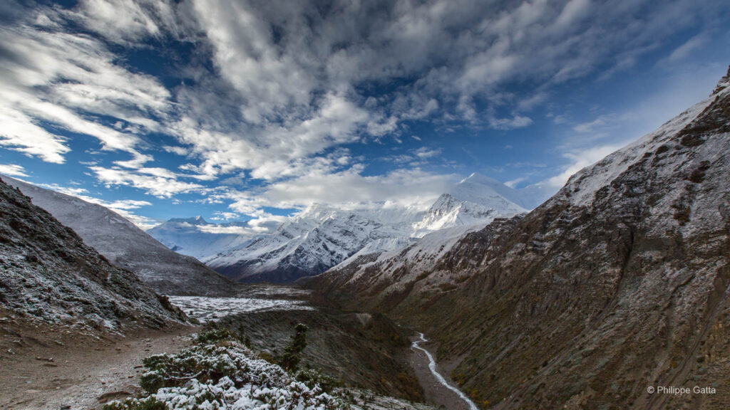
As the trail moves further north toward Singi and Sälka, the landscape shifts into a treeless tundra. Unlike the steep, enclosed valleys typical of the Tour du Mont Blanc, the terrain here is defined by large U-shaped glacial valleys offering high visibility. The climate is subarctic and variable. Even in July, hikers must be prepared for rain, persistent winds, and temperatures dropping toward 0°C. The trail is marked by red “X” signs on poles, designed for winter navigation, as the route is also popular for ski touring. Strategically placed STF (Swedish Tourist Association) huts are spaced every 10–20km, providing shelter, though many experienced hikers prefer self-sufficiency with four-season tents to withstand the mountain winds.
Kebnekaise: The Arctic Apex
Kebnekaise is the highest mountain in Sweden, situated about 150km north of the Arctic Circle. It consists of two distinct peaks: the Sydtoppen (South Peak) and the Nordtoppen (North Peak). Historically, the South Peak was the highest due to its covering glacier. However, due to recent glacial melting, the rocky Nordtoppen (2,097m) is now frequently the highest point in the country.
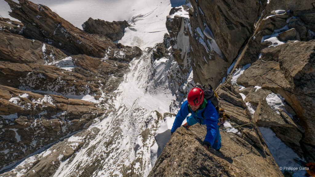
The standard ascent from the Mountain Station (690m) follows the Västra Leden (Western Route). It is a strenuous 18km round trip with a total vertical gain of approximately 1,800m, as the path requires crossing the intermediate peak Vierramvare. The terrain is predominantly boulders and scree, requiring stable footwear and physical endurance rather than technical climbing skills. For those choosing a direct line, the Östra Leden (Eastern Route) includes a glacier crossing and a section of via ferrata, necessitating a guide or technical mountain equipment.
130 km along the Kungsleden Trail
We started the Kungsleden trail in Nikkaluokta after traveling from Stockholm to Kiruna. We ran the trail in four stages, including an ascent of Kebnekaise, the highest mountain in Sweden, on the second day before continuing to Sälka.
The stages:
- Nikkaluokta – Kebnekaise: 19km (+300m / -130m)
- Kebnekaise summit: 20km (+2,000m / -2,000m)
- Kebnekaise – Sälka: 27.5km (+530m / -390m)
- Sälka – Alesjaure: 26km (+615m / -660m)
- Alesjaure – Abisko: 34km (+185m / -620m)
August 14: Nikkaluokta – Kebnekaise mountain lodge: 19km, +300m / -130m
We started the Kungsleden at Nikkaluokta, running through mountain birch forests. After 6km, we reached a large lake where there is an option to take a boat to bypass 7km of the trail. A small hut in this area provides local food for travelers.
Following a section on wooden planks to manage the wet terrain, the trail became rocky, offering views of the landmark Tuolpagorni summit. Before reaching the mountain station, we crossed several rivers and observed two reindeer.
The Kebnekaise mountain lodge is a well-equipped facility with a restaurant, showers, and a sports shop. We used the bunk beds for the night. A notable feature of the location is the frequent helicopter traffic transporting visitors to and from Nikkaluokta. We rented crampons to prepare for the ascent of Kebnekaise the following day, using our trail running shoes.
August 15: The Kebnekaise climb: 20 km, +2000m / -2000m
Kebnekaise is the highest mountain in Sweden (2,106m). The West Route is the standard path to the summit. As we were using trail shoes with rented crampons, we chose this route, which involved crossing rivers and moving over scree slopes.
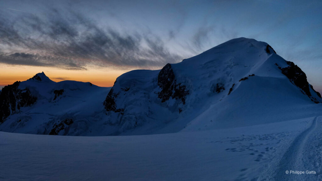
We climbed to the summit of Vierramvare before descending and then ascending the final slope to reach the shelters at approximately 1,900m. We encountered strong winds above the shelters and limited visibility, seeing the glacier summit only as we approached within 10m.
We used crampons for the glacier section and reached the summit in four minutes. Visibility remained limited due to the wind. We immediately descended to a shelter to eat before continuing the return journey. Despite the lack of views, the summit was a successful objective for us.
August 16: Kebnekaise mountain lodge – Salka mountain hut: 27.5 km, +530 m / -390m
After leaving the Kebnekaise area, we entered an open landscape and used the rivers for water supply. After 9km, the trail led into the Singi valley. We passed lakes with views of Ladtjovagge and Tjäktjavagge under a cloudy sky. Following a stop in Singi, we continued toward Sälka, where the route merged with the southern section of the Kungsleden. The terrain was manageable, and we observed Foehn effects in the sky near the Kebnekaise summit. We followed the valley toward Sälka in strong winds.
August 17: Salka mountain hut – Alesjaure mountain hut: 26km, +615m / -660m
We started early as the mornings usually provided some sun. We observed ten reindeer in the area shortly after setting off. Most of the trail leading toward the Tjäktja Pass (1,140m) followed wooden planks. When we approached the ascent to the pass, the wind velocity increased significantly. Due to the arctic wind, the sky featured distinct cloud formations. However, once behind the pass, the wind was strong enough to make standing difficult. We were moved to the sides on the rocky trail and were required to remain focused while running. We had the wind behind us, which assisted our progress at times. We passed the Tjäktja shelter and for a period the wind subsided, allowing some sun to reach the valley.
For a long duration, we ran on grassy trails along a river, but the wind eventually returned. The descent toward the Alesjaure huts was challenging due to the constant gusts. We often ran on wooden planks where the wind made balance difficult. The sight of the well-located huts was a relief as we arrived at Alesjaure before the weather deteriorated further. It was another day without rain, which is a notable condition in Lapland.
August 18: Alesjaure mountain hut – Abisko: 34km, +185m / -620m
Once again, we started early, running along the west side of Alesjaure Lake. We encountered a herd of reindeer and stopped for a period of time to observe them in the quiet morning. This 34km stage was our longest day of movement, and we maintained a steady pace running beside the lake and later along the slopes of Kartinvare. After some time, we saw Abiskosjaure Lake from the plateau and entered the birch forest near the Abiskojaure huts. From this point, we had 9km to run before reaching Abisko by the shores of the large Torneträsk lake.
In Abisko, we had a hot meal following the journey. Instead of resting for the remaining two days in Abisko, Philippe ran 20km each day along the shores of Torneträsk. In total, we completed five days of continuous movement (or seven for Philippe) without encountering any rain during the entire trip.
Information & Logistics
Region and Environment
This section of the Kungsleden lies north of the Arctic Circle (approx. 68°N), traversing the undisturbed wilderness of Swedish Lapland. Unlike the southern sections, the route between Nikkaluokta and Abisko is characterized by alpine terrain. The trail navigates through large U-shaped glacial valleys like *Tjäktjavagge*, crosses the Tjäktja Pass (1,150m), and winds through the birch forests of Abisko National Park.
The geography ranges from the tundra of the high plateaus to the deltas near Alesjaure. The summer features the phenomenon of the Midnight Sun (until mid-July), providing 24 hours of daylight. This allows for flexible running schedules, as there is no risk of darkness.
Climate and Best Time to Go
The hiking season is short, typically running from late June to mid-September.
- Late June to mid-July: The Arctic spring. Expect 24-hour daylight and green valleys, but also wet trails, snow patches on passes, and mosquito activity.
- Late July to August: The popular window. Trails are drier, and water levels in rivers are lower. Mosquitoes decrease in August, and darker nights return, bringing cooler temperatures.
- September: The *Ruska* period. The landscape turns to varied shades of orange and red. Insects are gone, and the air is crisp. Nights can drop below freezing, and early snow is possible. This is also the start of the Aurora Borealis season.
Temperatures are variable. A summer day can reach 20°C, but it can also drop to 5°C with sleet and high winds. Weather-appropriate gear and thermal layers are required, even in July.
Logistics: Huts and Camping
The trail is supported by a network of huts operated by the Swedish Tourist Association (STF), spaced 10–20km apart.
- Facilities: These are rustic cabins managed by a warden (*Stugvärd*). They provide gas stoves, mattresses, and blankets. There is no electricity or running water inside; water is collected from nearby streams.
- Shops and Saunas: Most huts on this section (Kebnekaise, Sälka, Alesjaure, Abiskojaure) have small shops selling dried food, pasta, and snacks, allowing a lighter pack. Several huts also feature wood-fired saunas, which are a part of the Swedish hiking experience.
- Camping: Under the Swedish *Allemansrätten* (Right of Public Access), camping is permitted along the trail. However, in Abisko National Park, camping is only permitted at designated sites like the Abiskojaure huts.
Transport
The logistics for this point-to-point route are efficient, with Kiruna serving as the central hub.
- Start (Nikkaluokta): From Kiruna (accessible by flight or night train from Stockholm), the local bus Nikkaluoktaexpressen runs twice daily during the season. The trip takes about one hour.
- Finish (Abisko): The trail ends at the Abisko Turiststation. This location has its own train station on the main line. From here, you can take a train or bus back to Kiruna or continue toward Narvik (Norway). Booking trains in advance via SJ is recommended during the high season.