Carstensz Pyramid, West Papua
The Enigma of the Pacific: Carstensz Pyramid
The pursuit of the Seven Summits eventually leads every climber away from the familiar high-altitude glaciers of the northern hemisphere and toward the dense, equatorial mists of the western Pacific. Rising abruptly from the primary rainforests of the island of New Guinea, Carstensz Pyramid (4,884m)—also known as Puncak Jaya—represents a geographical anomaly. It is the highest point between the Himalayas and the Andes and the definitive summit of the seventh continent (Australia/Oceania).
The history of the mountain is as secluded as its location. First sighted in 1623 by Dutch explorer Jan Carstensz, his reports of snow near the equator were initially met with disbelief in Europe. It was not until 1962 that Heinrich Harrer and his team achieved the first successful ascent, finally confirming the presence of this limestone fortress hidden in the clouds.
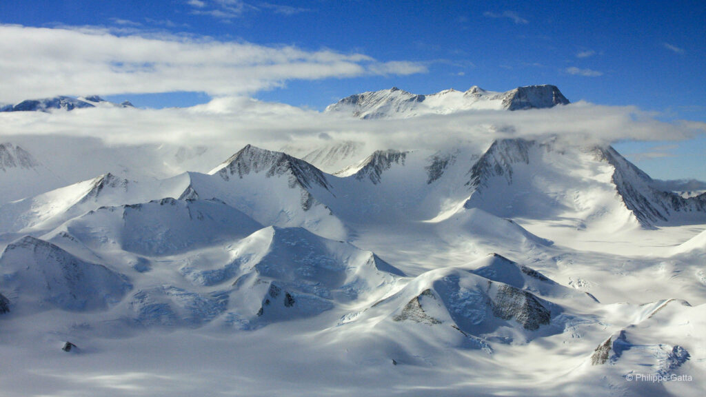
Approaching the mountain is a journey into one of the most mysterious environments on Earth. Tucked within the Sudirman Range, the peak stands as a vertical anomaly above an impenetrable canopy of jungle. While the surrounding highlands feature easier terraces, the Pyramid itself is defined by sheer cliffs and the rare remnants of equatorial glaciers, creating a stark contrast between the grey stone and the lush green world below.
Environmentally, the peak is a place of constant transition. Temperatures fluctuate between -3ºC and 15ºC, with clear mornings often giving way to heavy tropical rainfall or snow by the afternoon. This perpetual shift between heat and cold, jungle and ice, gives Carstensz its unique and wild character, making it a profound final objective for any mountaineer seeking to complete the highest points of the seven continents.
Carstensz Pyramid Historic Timeline
First Sighting
Dutch explorer Jan Carstensz spotted the snow-capped peaks from the sea. His reports of “eternal snow” near the equator were initially disbelieved in Europe.
The Carstensz Expedition
A Dutch team led by Anton Colijn reached the glaciers. They climbed several neighboring peaks, but the main Pyramid remained unclimbed.
First Ascent
Legendary climber Heinrich Harrer led the first successful summit team via the North Face, establishing the technical standard for the mountain.
The Bass vs. Messner Debate
Mountaineering legends debated the Seven Summits definition; Messner successfully argued that Carstensz was the true geological high point of Oceania.
The Helicopter Era
Helicopter access over the Grasberg Mine became a common logistical solution to avoid tribal conflicts and the arduous jungle approach.
Geopolitical Closures
The mountain has faced multiple closures due to political unrest in West Papua, making it one of the most elusive summits to permit.
The Tropical Glaciers
Carstensz remains a vital site for studying climate change, as its rare equatorial glaciers are rapidly receding and may soon vanish.
The Expedition
Carstensz: A Complex Organization
Organizing the expedition to Carstensz Pyramid was particularly difficult. The regional political situation, combined with the complexities of securing permits and the ongoing tensions in the jungle, made for a very uncertain preparation.
I eventually managed to find a solution by teaming up with a Portuguese climber, Angelo, accompanied only by a single liaison officer. This minimal team allowed us to navigate the logistical hurdles of a region that remains largely closed to the outside world.
The journey to reach the base camp was unlike any of my previous expeditions. I cannot describe the details of our approach here, but navigating the restricted environment of West Papua proved to be one of the most unusual and sensitive experiences I have encountered. It was a journey defined by isolation and a constant sense of uncertainty, where reaching the foot of the mountain was a challenge in its own right.
March 30: Base Camp - Carstensz Summit - Base Camp
At 3:00 AM, we woke to light rain and a temperature of 5°C. Due to the extreme tropical humidity, the cold was deceptive; I dressed in layers similar to my experience at Vinson base camp in -20°C.
By 4:30 AM, we began the ascent, climbing 100 meters to a pass before descending into a small valley. We passed several high-altitude lakes in the dark, reaching the base of the Carstensz wall at 4,350m by 5:30 AM.
With the rain finally stopping, we prepared our technical gear. We put on our harnesses and helmets, left a pack behind to lighten our load, and began the climb. I led the way, followed by Angelo and Danny, as we started up the fixed lines on the steep limestone face.
The Lower Face
The first three pitches are steep but not technically difficult. The rock quality is excellent—solid and offering high friction, even when wet. These initial pitches lead to a shelf, followed by 50 meters of scree and relatively easy terrain.
Beyond the scree, the route becomes significantly wetter. We tackled two to three pitches of 60-degree slabs and gullies. These sections act as natural channels where water constantly pours down from the upper reaches of the mountain, requiring focused movement through the runoff.
Mid-Section
Above the slabs, another 40 meters of steep scree awaited us, covered in 5 to 10cm of snow. The surface was slippery, requiring constant focus. Fortunately, the mist cleared, offering a fantastic view of Ngga Pulu (4,862m) and our first clear look at the summit ridge and the Tyrolean traverse.
After this section, a steep pitch led toward the final wall. However, I made a route-finding error, traversing left too early. This cost us both time and energy before we finally reached the correct base of the final wall.
The final wall consisted of 2 to 3 steep pitches, ending on the ridge beside a prominent rock tower. At this point, we stopped to switch to dry gloves; our first pairs were completely soaked from the constant runoff in the gullies below.
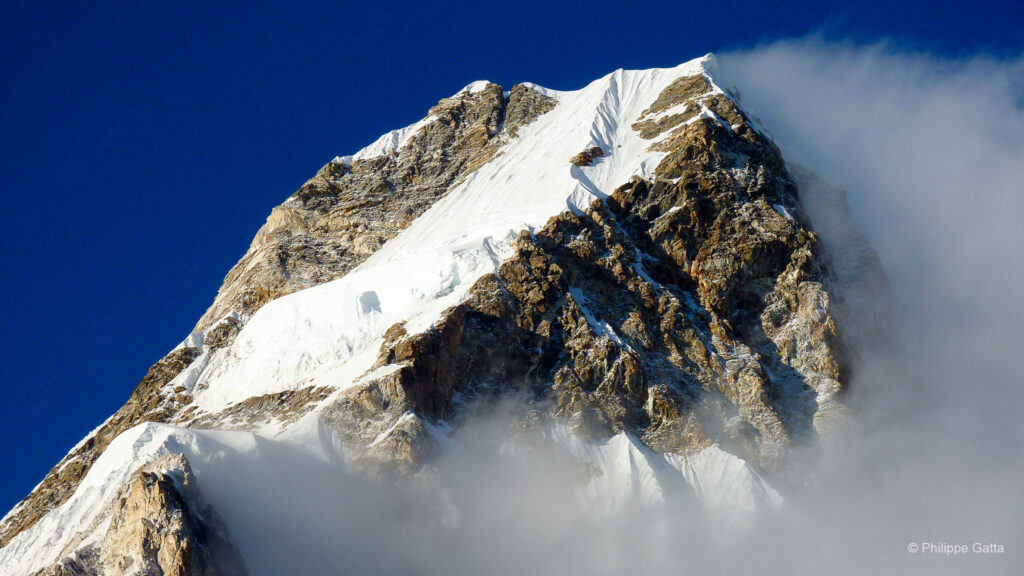
The Summit Ridge and the Final Gap
At 7:40 AM, we reached the ridge (4,745m). We caught a fleeting glimpse of the South face and the endless forest below before the mist returned. The entire crest was covered in ice and snow, making every move delicate.
To cross the famous gap, we chose the Tyrolean traverse. The four fixed ropes were encased in 2cm of ice, which I had to break manually as I progressed—a process that took ten minutes of effort. Beyond this, two more notches required down-climbing and ascending to stay on the jagged line of the ridge.
The final push on the South face led us to the summit, reached in exactly three hours from the base of the wall. In typical Carstensz fashion, we stood in total whiteout, surrounded by clouds with no visibility—the standard end to a journey in the Sudirman Range.
The Descent
The weather deteriorated rapidly as we began our move off the summit. The descent required 2 hours and 30 minutes of continuous down-climbing and rappelling to clear the 500-meter face.
With the rain picking up, the limestone gullies became increasingly slick, but we maintained a steady pace until we reached the bottom of the wall. From there, it was a gentle trek back to the safety of base camp.
Ngga Pulu (4,862m)
The Vanishing Second Peak
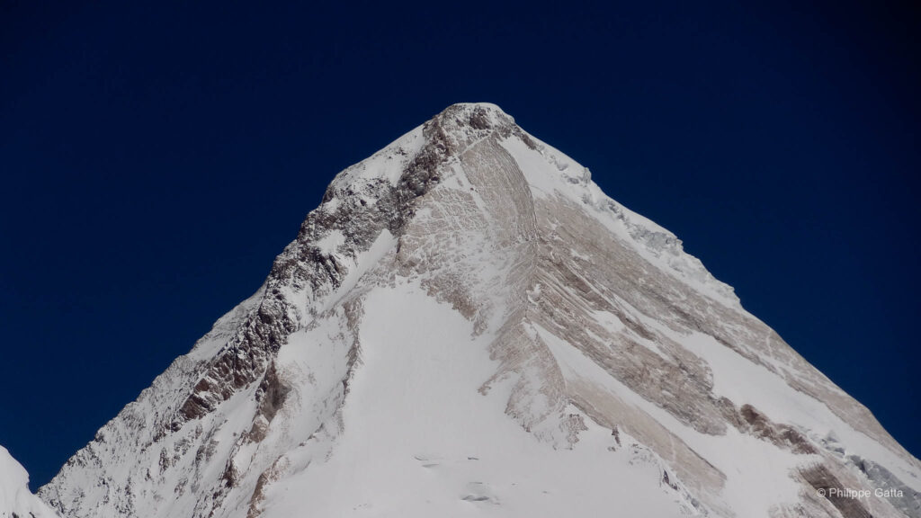
Since we completed the ascent of Carstensz Pyramid faster than anticipated, we took advantage of our remaining time to climb the second-highest peak in the Sudirman Range: Ngga Pulu (4,862m).
Reaching this summit is a journey through both geography and history. In 1936, Ngga Pulu was actually measured at 4,907m—higher than Carstensz itself—due to its massive glacial cap. However, the rapid melting of equatorial ice has caused the mountain to lose significant elevation over the decades, eventually leaving the bare limestone of the Pyramid as the definitive high point of the continent.
Standing on its summit offered a rare perspective on some of the world’s last tropical glaciers. These ice fields are predicted to vanish entirely within the next few years. The pristine white dome of Ngga Pulu provided a stark, beautiful contrast to the dark limestone we had just climbed, serving as a powerful conclusion to our time in the Sudirman Range.
Historical & Technical Summary
In 1936, the Dutch expedition led by Anton Colijn made the first ascent of Ngga Pulu. At the time, it was the highest summit in the region (4,907m), as its thick glacial cap sat well above the rocky peak of Carstensz Pyramid.
The Route: Historically, Ngga Pulu was a classic glacial climb. Mountaineers would ascend the Northwall Glacier, a world of deep crevasses and white domes. It was a stark contrast to the technical rock climbing found on the neighboring peaks.
The Change: Due to climate change, the route has evolved. The thinning ice has exposed the underlying limestone, turning the ascent into a mix of rock slabs and retreating snowfields. What was once the highest point of Oceania is now a poignant symbol of the vanishing equatorial glaciers.
The Easy Ascent
We scaled Ngga Pulu (4,862m) the day after Carstensz. The climb starts from the same base camp, heading East through a “chaos of big rocks” before turning left toward the main ridge. Once on the ridge, we followed the large slabs just East of the glacier.
We reached the summit once again in the fog and clouds. However, a brief clearing allowed us to see the jungle at the foot of the steep face before the mist returned. This was our final climb in the Sudirman Range.
Return to Civilization
The return journey provided a detailed view of the Grasberg Mine and its giant crater. The contrast was striking: we moved from the isolation, silence, and natural stillness of the mountain into a world of extreme noise and relentless industrial activity.
Watching the massive machinery gradually carving away the range created a desolate spectacle. Our return to civilization was as epic and risky as the approach. Angelo and I hold a very specific, enigmatic memory of this expedition; looking back at the photographs now, they serve as the only proof that the experience was real.
Completion of the 7 Summits Challenge
For me, Carstensz was the last of the Seven Summits. It marks the end of a challenge, but more importantly, the completion of a project that allowed me to discover the beauty and diversity of all seven continents over several years.
Information
Politics & Access
Since 2000, the geopolitical situation in West Papua has remained volatile. Access to the mountain is strictly regulated by the Indonesian government due to ongoing tensions with local separatist movements and the proximity of the Grasberg Mine.
To bypass these security risks and the arduous 6-day jungle trek, most modern expeditions now rely on helicopter transport. Flights typically depart from Nabire or Timika, landing directly at Yellow Valley (4,250m). However, this approach is entirely dependent on the region’s notorious weather, often resulting in long delays waiting for a clear window through the clouds.
The Grasberg Influence: Industry in the Wilderness
The story of Carstensz Pyramid is inseparable from the Grasberg Mine, located just a few kilometers from the summit. It is one of the largest gold and copper mining complexes in the world, covering an area of approximately 100 square kilometers. The open-pit crater, over 3 kilometers wide, is a massive landmark visible from space.
The scale of the operation is reflected in its workforce of around 30,000 employees. Production is staggering, with the facility capable of processing more than 200,000 tonnes of ore per day, making it a central pillar of the regional economy.
However, the environmental impact on the Sudirman Range is profound. Tailings management and the disruption of local river systems have significantly altered the surrounding ecosystems. The presence of such immense mineral and potential oil wealth has also shaped the geopolitical complexity of West Papua, leading to the high-security environment that climbers encounter today.
Access to Base Camp
The Jungle Trek: The Traditional Path
Historically, the only way to reach the mountain was a grueling 5 to 7-day trek through some of the densest rainforests on Earth. Starting from villages like Ilaga or Sugapa, this route is a test of endurance against deep mud and constant tropical downpours. Beyond the physical toll, this path is defined by its human complexity and regional security risks.
The Helicopter Approach: A Surreal Transition
The standard modern approach is a helicopter flight from Nabire or Timika. This flight offers a surreal perspective, soaring over the Grasberg Mine—a massive industrial scar in the middle of the pristine equatorial wilderness. Landing at Yellow Valley (4,250m) is the fastest way to reach the rock walls, though it is entirely dependent on clear weather windows.
The Mine Road: The Industrial Shortcut
A more restrictive option involves crossing the Grasberg Mine complex. This requires rare and specific permits to travel via private mining roads in armored vehicles. It is a stark, industrial experience that bypasses the jungle entirely, dropping climbers at the edge of the mine for a final trek toward the base of the Pyramid.
The North Face Ascent
The ascent of Carstensz Pyramid is a purely technical rock climb, unique among the Seven Summits. The route follows the North Face, navigating 500 meters of vertical limestone gullies and chimneys.
The North Face: The climbing is sustained on remarkably solid but razor-sharp limestone. While much of the route involves moderate climbing, technical crux sections reach a difficulty of 5.10 (UIAA VI). The rock provides incredible friction even when wet, though it is notoriously abrasive on gear and skin.
The Summit Ridge: Upon cresting the face, the route follows a jagged, 500-meter-long exposed ridge. Climbers must navigate notches and gaps, often utilizing a Tyrolean traverse to cross some sections.
The Descent: Returning to Base Camp requires a long series of rappels and down-climbing. As tropical rainfall typically begins in the afternoon, the descent is often a race against time before the gullies transform into waterfalls.