The Roof of the World
Rising to 8,848 meters (29,032 ft) in the Himalayas, Mount Everest is the highest point on Earth. Known as Chomolungma (“Goddess Mother of the World”) to Tibetans and Sagarmatha in Nepal, the mountain straddles the border between Nepal to the south and China (Tibet) to the north. For nearly a century, it has been a focal point for exploration and mountaineering. Since the first reconnaissance expeditions in the 1920s, Mount Everest has served as a significant stage for human endurance. Many historical events have unfolded on its high ridges, connecting the early pioneers to modern alpinists. This history represents a continuous thread of adventure, from the mystery of Mallory and Irvine to the first successful ascent by Hillary and Norgay.
The Two Routes: South vs. North
Climbers typically ascend Mount Everest via two main lines: the Southeast Ridge from Nepal and the Northeast Ridge from Tibet. Both routes reach the summit at 8,848m, but they present distinct topographical and technical characteristics.
The Southeast Ridge (Nepal)
The southern route begins at base camp (5,364m).
- Camp 1 (6,065m): Located above the Khumbu Icefall, a moving glacier section characterized by deep crevasses and ice towers (seracs).
- Camp 2 (6,400m): Situated in the Western Cwm, a broad glacial valley.
- Camp 3 (7,300m): Positioned on the Lhotse Face, an expanse of blue ice angled between 40 and 50 degrees.
- Camp 4 (7,925m): Located on the South Col, a high-altitude plateau serving as the final staging point.
Technical Difficulties: The primary technical obstacle is the Khumbu Icefall, which requires the use of fixed ladders and ropes to navigate shifting ice. Higher up, the Hillary Step (located at 8,790m) was previously a 12-meter rock and ice vertical step; however, since the 2015 earthquake, it has changed into a steep snow and rock slope.
The Northeast Ridge (Tibet)
The northern route begins at base camp at 5,150m, with an advanced base camp (ABC) at 6,400m located on the East Rongbuk Glacier.
- Camp 1 (7,000m): Situated at the North Col, reached by climbing a steep snow and ice slope.
- Camp 2 (7,800m): Located on the North Ridge, exposed to strong winds.
- Camp 3 (8,300m): The final camp, positioned on narrow rock ledges.
- Technical Difficulties: The north side involves more rock climbing at higher altitudes than the south.
The upper section is defined by three distinct rock steps:
- First Step (8,500m): A series of large boulders and rock slabs.
- Second Step (8,600m): The most significant technical section, featuring a vertical rock buttress equipped with a permanent metal ladder.
- Third Step (8,700m): A final rock tier before the summit snow slopes.
Everest Historic Timeline
The Mallory and Irvine Mystery
George Mallory and Sandy Irvine attempted the North Face. They were last sighted on June 8 near the Second Step. The discovery of Mallory’s body in 1999 yielded no proof they reached the top, leaving the mystery intact.
The First Ascent
On May 29, Edmund Hillary and Tenzing Norgay reached the summit via the Southeast Ridge. This British expedition, led by John Hunt, marked the successful “conquest” of the Third Pole.
The First North Ridge Ascent
A Chinese expedition achieved the first successful ascent via the North Face, installing the famous metal ladder on the Second Step that is still used by climbers today.
First Ascent Without Supplemental Oxygen
Reinhold Messner and Peter Habeler defied medical dogma by reaching the summit without bottled oxygen, proving that humans could survive at the highest point on Earth by their own means.
Winter and Solo Ascents
A Polish team completed the first winter ascent in February. Later that year, Reinhold Messner returned to achieve the first solo ascent, without oxygen or assistance, during the monsoon.
Hornbein Couloir Speed Ascent
Erhard Loretan and Jean Troillet climbed the North Face via the Hornbein Couloir in a 43-hour round trip without tents or supplemental oxygen, defining the “light and fast” alpine style on Everest.
The Year of Achievements
Jean-Marc Boivin completed the first paraglider flight from the summit, and Marc Batard set a speed record, reaching the summit from Base Camp in 22 hours and 29 minutes without oxygen.
The Age of Snow Sports
Following Davo Karničar’s full ski descent in 2000, Marco Siffredi achieved the first full snowboard descent via the Norton Couloir on the North Face.
Fastest Known Time
Kilian Jornet climbed Everest twice in one week from the Rongbuk Monastery without supplemental oxygen or fixed ropes, bringing the mountain into the era of modern trail running.
The Expedition
The Team
We were six independent climbers who shared logistics, expedition costs, and the climbing permit. Jamie McGuinness organized the logistics and managed the expedition. He had already successfully led and summited several 8,000-meter peaks.
His experience, patience, and kindness were crucial during this expedition and the many subsequent adventures we shared, including the Great Himalaya Trail. Beyond mountaineering, Jamie is driven by two other passions: photography—with several of his shots published by National Geographic—and meteorology. In fact, he served as my weather router on many occasions thereafter.
It was also during this expedition that I met Pasang Gombu. Later, we paired up to climb Makalu together, and he also joined Anna and me to run several sections of the Great Himalaya Trail.
Finally, I have a very special memory of Namgyal, his optimism, and his boundless energy. It was with great sadness that I learned of his passing a few years later on this same Everest route.
The Ascent
April 17 - May 16: Kathmandu to Everest Base Camp
We arrived in Kathmandu on April 15. The first two days were dedicated to a complete review of equipment, food supplies, and final logistical details. The team then divided: one group transported the 2.5 tons of gear by road, while we flew to Lhasa (3,660m) before beginning the long crossing of the Tibetan Plateau.
On April 23, we regrouped at base camp, at an altitude of 5,150m. Until May 16, we carried out successive rotations between base camp and the North Col (7,050m). These three weeks of rotations were essential to acclimatize to the altitude. In parallel with the acclimatization, we managed the load carrying—food, stoves, sleeping bags, and technical gear—to progressively establish our high-altitude camps.
May 17: BC (5,150 m) - Intermediate Camp (5,750 m)
We were on the 24th day of the expedition. Ten days have passed since our last rotation to the North Col at 7,050m. Despite three hours of daily training, a sense of concern is setting in: this prolonged rest at Base Camp (5,150m) might have undermined our acclimatization.
My measurements seem to confirm this feeling: my oxygen saturation has dropped from 90% to 86% in just a few days. This wait is intentional: we chose to let the commercial expeditions go through, as they took advantage of the very first window. We will have more peace on Everest now, but the weather window around May 21 and 22 is uncertain, and the wind is picking up again.
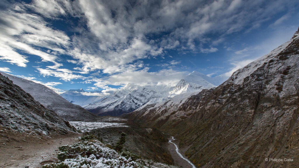
We finally decide to move up, betting on an improvement in conditions. Today’s stage is a 12km trek on the East Rongbuk Glacier to reach the Intermediate Camp at 5,750m.
May 18: Intermediate Camp - Advanced Base Camp (6,450m)
We continued our progression on the East Rongbuk Glacier by taking the famous “Miracle Highway.” This route owes its name to the early British explorers of the 1920s: it is a moraine, a wide strip of stones and debris that splits the glacier in two.
Following this line allowed us to avoid a maze of crevasses for nearly 10 km, making the walk much easier and faster. After a final steep rise, we reached the Advanced Base Camp (ABC) at 6,450m.
May 19: Rest day
We stayed at the Advanced Base Camp to recover from the last two days. We took the opportunity to review the equipment and food that we will carry up to the North Col of Everest.
May 20: ABC - Camp 1 at the North Col (7,050 m)
From the advanced base camp, the route toward the North Col climbs into an immense glacial cwm, surrounded by three ice walls: Everest on the left, Changtse on the right, and the wall of the Col directly ahead. In clear weather and without wind, the reflection transforms this cirque into a literal solar oven. Having already “cooked” during our previous acclimatization rotations, we chose to leave very early. Unfortunately, Geff, who was ill, had to withdraw from accompanying us.
The climb eventually went smoothly, despite the significant weight of our backpacks. Once we reached the North Col (7,050m), we dedicated the rest of the day to rest and hydration.
May 21: Rest day at the North Col
I’m not sure we actually needed this rest day; many teams skipped it and pushed directly to Camp 2. Regardless, we stayed here at 7,050m all day, melting snow for water, eating, and resting. Many climbers who summited earlier are passing by our tent; we encourage and congratulate them, but it is frightening to see just how exhausted they are.
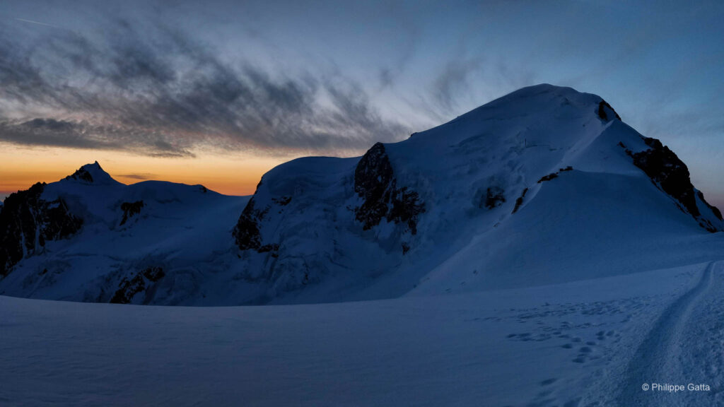
May 22: North Col - Camp 2 (7,700 m)
A radio call from Duncan, then at Camp 3, warned us: the day was set to be freezing and windy. Given the conditions, I decided to put on my down suit directly for the ascent. While the snow conditions were excellent, the wind never stopped strengthening during our progress.
Upon our arrival at Camp 2 (7,700m), gusts were already reaching 60 km/h. On this slope, the lack of flat ground forces tents to be scattered across the few available platforms. Confined in our small tent with Gavin, I followed the tense radio exchanges of Sherpas attempting to rescue a climber with a hand injury at the Second Step, above 8,600m.
The storm intensified during the night. As a precaution, we slept fully dressed with our gear packed in our bags, ready for the possibility of the tent fabric tearing under the violence of the wind.
May 23: Camp 2 - Camp 3 (8,300 m)
We received the latest weather forecast by radio early in the morning, and it was bad. The wind had strengthened, increasing from 40 km/h to 80 km/h, and summit temperatures were expected to drop to -25/-30°C.
We discussed it at length. Finally, Kirsti, Kevin, and Gavin decided to head back down. Namgyal and Nima, who wanted to attempt his first summit, wished to give it a try. I decided to go too. Jamie preferred to stay at Camp 2 to monitor our ascent. We set off immediately for Camp 3, which we reached in 4 hours. The scene at Camp 3 was terrible: the body of a climber who died two days earlier lay in the snow, tents were ripped open by the wind, and gear was scattered everywhere. We pitched our tent a bit higher up, anchored by snow pickets on a 30° slope. At 8,300 meters, this is the highest camp of all the 8,000m peaks, and only five mountains in the world are higher.
We spent the afternoon sitting, trying to nibble on something despite the lack of appetite. The wind was still blowing just as hard. At 11:00 PM, we had all our clothes on and not a single millimeter of skin was exposed to the wind. We wore our ski goggles, even though it was night, to protect our eyes from frostbite. I slipped two bottles of boiling water inside my down suit. It took some time to put on the crampons; the buckles were frozen and the metal was so cold it stuck to the gloves. At 11:30 PM, we were ready to leave.
May 23: Departure from Camp 3 at 11:30 PM
We left the tent at 11:30 PM (on the 23rd); the wind was not too strong, but it was very cold. The first part of the ascent up to the Exit Cracks (8,500m) was steeper and more technical than I had thought. Fresh snow had accumulated, and breaking trail, sometimes calf-deep in the less steep sections, was exhausting. Between the darkness of this moonless night and the spindrifts, we could see nothing.
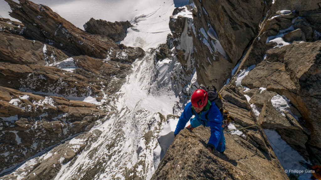
It was a relief to reach the ridge at 8,500m, where we found harder snow, but we were also much more exposed to the wind. It had weakened slightly, but it was freezing. We reached the First Step; it is a short climb over large boulders (PD, II), but I have no memory of this section—a memory gap of at least thirty minutes. Then, the traverse continued to the right along the narrow ridge.
Second Step (8,610 m)
The Second Step (8,610m) was the most challenging section of the route. The lower part consisted of large boulders that I climbed awkwardly, using my knees, elbows, and any leverage possible. Above this, a steep snow couloir led to the foot of the famous ladder. This ladder was originally placed by a Chinese expedition in 1960 to help climbers cross the vertical wall. Climbing the ladder was straightforward, but the traverse at the top was exposed and technical. Passing the Second Step was a significant boost for morale; I knew that I was within two hours of the summit and that the remainder of the ridge would be less demanding.
The Third Step was the easiest and shortest of the three. As the sun rose, the sky turned orange. Just above the step, I encountered the remains of two climbers only a few meters from the path. I had seen others at lower altitudes—some recent, others having been there for years. It was a sobering and saddening sight. While I understand the immense difficulty of recovering bodies at this altitude, seeing them so exposed was a difficult experience to witness.
From 8,700 m to the Summit
We caught up with the Colombian team on the final snow slope. Then, we left the ridge to head right, toward the impressive North Face of Everest, which we followed for a few pitches. This last section was very steep, dropping away in a single plunge down to the glacier, 3,500m below.
We exited the North Face to reach the summit ridge, which we followed to the summit of Everest. We reached it at 5:45 AM.
Summit of Everest - Camp 3
At 6:30 am, it was time to descend. Namgyal stayed a bit longer to take more photographs. The descent proceeded without incident until I reached the Second Step, at which point Nima and Namgyal were significant distance behind me. I began the descent anyway, but soon my left foot became tangled in several old ropes. I was unable to move up or down, and the fixed rope was positioned too low to be of use.
I focused on remaining calm. I removed my oxygen mask to better assess the situation and then replaced it to rest briefly between efforts. Eventually, I managed to free my foot and moved slowly to reach the top of the ladder. The entire process took approximately 15 minutes, but I was able to continue my descent. I did not fully trust the old fixed ropes, so I chose to down-climb rather than rappel. While slower, this method felt more secure, and I eventually reached Camp 3 around 9:00 am.
Camp 3 - Camp 2
We stayed there for a few minutes to melt snow for water and have a snack before I continued the descent alone. At 8,000m, a significant altitude, I stopped to record one last video.
I reached Camp 2 around 11:30 am. Jamie gave me half a liter of juice, which was a welcome relief. I realized I was still carrying water inside my down suit, though the extreme cold had made it undrinkable. Since leaving camp twelve hours earlier, we had consumed very little, and I felt the effects of severe fatigue. With the wind reaching 80 km/h (50 mph) and conditions deteriorating, we could not remain there and had to descend quickly.
Camp 2 - Everest North Col
The descent to the Everest North Col took almost four hours, compared to the five hours it had taken me to climb it with a heavy pack a few days earlier. On several occasions, I sat in the snow, struggling to stay awake. I eventually reached the North Col at 3:30 pm. We had been climbing for sixteen hours, carrying 22 kg of equipment, mostly above 8,000m in deep snow and extreme cold. I had reached my limit for the day and decided to stay there, planning to continue the descent to Advanced Base Camp the following morning. I spent a final night at the campsite, knowing the expedition was successfully nearing its end.
May 24: Everest North Col - Advanced base camp
After a restful night, I felt significantly better and was prepared for the final descent. Jamie and I disassembled our two tents, gathered our equipment, and set off with heavy packs. Just before reaching Advanced Base Camp, Jamie realized he had left his camera where we had removed our crampons. He headed back up to retrieve it while I ate my first substantial meal in several days. In the afternoon, I packed my gear (40 kg / 88 lbs) to be transported down by yaks.
May 26: Advanced base camp - Base camp
I left Advanced Base Camp and was relieved to traverse the Rongbuk Glacier for the final time. Four and a half hours later, I reached base camp, marking the end of the Everest expedition. It was a relief to return to the higher oxygen levels at this altitude. I spent the remainder of the afternoon packing and recovering.
May 27 - 28: Base Camp - Zanghmu (2,300m) - Katmandu
The journey from Everest base camp to Kathmandu along the Friendship Highway was an arduous experience. The terrain was rough and barely resembled a road, although the scenery moderated the lack of comfort. It took fourteen hours by 4WD to reach Kathmandu. We stayed at a hotel in Zhangmu that was quite rudimentary, but it offered the luxury of a first shower in weeks.
Crossing the border between China and Nepal was the final hurdle, particularly as I had misplaced my visa documents in the rush. Fortunately, our representative from the Chinese Mountaineering Association managed the immigration process effectively, sparing me what could have been a lengthy investigation.
Information
The Climate of Everest
The climate of Mount Everest is governed by its geographic position at the edge of the troposphere and by the seasonal cycle of the South Asian monsoons. At 8,848 meters, the mountain directly intercepts the Jet Stream, a high-altitude current blowing from west to east.
Temperatures and Pressures. Summit temperatures never rise above freezing. On average, they fluctuate between -19°C in summer and -36°C in winter, with occasional drops reaching -60°C. Atmospheric pressure at the summit is approximately 337 mbar, or one-third of the pressure at sea level, which reduces oxygen availability by nearly 70%.
Wind Patterns. Wind is the primary limiting factor. During the winter, the Jet Stream shifts south in latitude and hits the summit with speeds regularly exceeding 200 km/h, making any progression impossible. In summer, the monsoon brings massive snowfall and an increased risk of avalanches.
The “May Window”: Why May 15th? The most favorable period for the ascent usually falls between May 10th and May 25th. This weather window corresponds to a precise transition phase:
- Displacement of the Jet Stream: Around mid-May, the jet stream is pushed north over the Tibetan Plateau by the arrival of warm air masses from the monsoon. This leads to a sudden drop in wind speeds at the summit.
- The Lull Before the Monsoon: This period offers a few days of relative stability before the moisture from the Indian monsoon reaches the Himalayas in late May or early June, bringing heavy snow and zero visibility.
Attempting the summit around May 15th therefore allows climbers to benefit from milder spring temperatures while avoiding the extreme winds of winter and the snowstorms of the summer monsoon.
The Northeast Ridge Route
This itinerary, located entirely in Tibet (China), is renowned for its exposure to the wind and its technical high-altitude challenges. Unlike the southern slope, it does not involve an icefall, but it requires staying at very high altitude for a long distance.
From Base Camp to the North Col
Base Camp (5,150 m): Accessible by road, it is located at the foot of the Rongbuk Glacier.
Advanced Base Camp (ABC – 6,450 m): Reached after a 22 km trek along the East Rongbuk Glacier, following the “Miracle Highway,” a central moraine strip that facilitates progression through the crevasses.
North Col (Camp 1 – 7,050 m): The ascent to the col is made over steep snow and ice slopes, requiring climbers to pass beneath threatening seracs halfway up.
The Upper Ridge
Camp 2 (7,700 m): The climb to this camp is exposed to westerly winds. Tent sites are limited and scattered across rocky ledges.
Camp 3 (8,300 m): The final camp before the summit push. It is not a flat area but a slope of snow and rock angled at about 30°.
Technical Difficulties of Summit Day
The section between 8,500 m and the summit is marked by three rocky barriers known as “Steps”:
First Step (8,500 m): A short section of large boulders with moderate technical difficulty (Grade II).
Second Step (8,610 m): The crux of the ascent. It begins with rocky blocks (III) and continues with a vertical slab equipped with a metal ladder installed in 1960. The exit at the top of the ladder is particularly exposed.
Third Step: A final rocky passage, shorter and easier (II), standing about 10 meters high.
4. The Final Stretch
After the Third Step, the route briefly traverses the very steep upper section of the North Face of Everest before joining the narrow summit ridge that leads to the highest point at 8,848m.