The Great Divide Trail
A Journey Through the Canadian Rockies
The Great Divide Trail (GDT) is a wilderness trekking route that traces the continental divide between British Columbia and Alberta. Unlike the developed trails often found in Europe or the United States, the GDT is a wild path. It is not always a continuous footpath but rather a collection of traditional hiking trails, forest service roads, and cross-country sections where the path may disappear into the brush or scree. For long-distance runners and hikers, this requires constant engagement with the terrain and navigational skills.
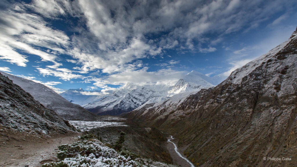
The route traverses a chain of protected areas, beginning in the Kananaskis region within Peter Lougheed Provincial Park. Moving northward, the trail enters Mount Assiniboine Provincial Park. From there, the path cuts through the wilderness of Banff National Park, navigating high-altitude passes and remote valleys far from the tourist crowds.
As the trail pushes further north into Jasper National Park, the environment becomes increasingly isolated, characterized by limestone ridges, glaciers, and alpine lakes. This large protected corridor is a habitat for wildlife, winding through grizzly and black bear country. The journey culminates in Mount Robson Provincial Park, ending beneath the Emperor Face of Mount Robson, the highest point in the Canadian Rockies at 3,954m.
The Wildlife Factor: Grizzly Country
A feature of the GDT compared to other alpine traverses is the wildlife. The entire route cuts through grizzly and black bear habitat. This reality affects the daily routine of any expedition. Traveling here means accepting the environment and maintaining bear awareness as a routine: cooking is done far from the sleeping area, and all food and scented items—toothpaste, sunscreen, wrappers—must be suspended in trees or stored in bear-proof canisters every night. This constant vigilance adds a layer of responsibility to the physical effort, as one must remain observant of the surroundings in the dense forest.
600 km along the GDT
From Peter Lougheed Visitor Centre to Mount Robson
Our expedition focused on the central portion of the trail: a 600km stretch starting from Peter Lougheed Provincial Park in Kananaskis and concluding at the foot of Mount Robson, the highest peak in the Canadian Rockies (3,954m).
This route traverses a landscape defined by verticality and isolation. Moving northwards, the trail crosses high-altitude passes such as Palliser Pass and Whistling Pass, taking explorers through protected areas including Banff National Park and Jasper National Park. One of the notable locations is Mount Assiniboine Provincial Park, dominated by Mount Assiniboine—a pyramid of rock often referred to as the “Matterhorn of the Rockies.” The terrain consists of a series of limestone ridges, glaciers, and colored alpine lakes.
The Expedition Plan
The plan was to complete this 600km section in seventeen days, in self-sufficiency.
- Total Distance: 600km
- Total Elevation Gain: 22,512m
- Daily Average: 35km and 1,330m of ascent
These statistics were comparable to our previous expeditions in the Himalayas or the Alps. However, the Canadian Rockies present specific challenges. The remoteness of the trail meant limited resupply points, requiring us to carry heavier loads. Our pack weight was over 12kg (excluding water), including four-season camping gear, rain gear, and bear safety equipment.
The itinerary was divided into stages, linking backcountry campgrounds. This included the limestone valleys of Section C, the corridors of the National Parks in Section D, and the isolated northern stretches of Section E. The objective was to move through the terrain efficiently. The finish line was located on the Berg Lake Trail, below the Emperor Face of Mount Robson.
Adapting to the Wild
The first seven days unfolded according to the planned schedule. We met our daily mileage targets and reached the designated campsites, but the reality on the ground was tougher than expected. The terrain proved to be more complex than the maps suggested. Navigation required significant mental effort; many trails were unmarked, poorly maintained, or unclear, forcing us to slow down to find our way.
Running in these conditions, carrying packs heavier than we had planned, took a physical toll. Our daily schedules lasted longer than expected. Even camp life was more demanding than in Europe. To comply with bear safety protocols, we had to cook and eat far from our sleeping area and suspend all food and scented items high in the trees—a process we repeated every morning and evening.
The weather affected our progress as well. Persistent rain turned the trails into mud, slowing our pace. After a few days, our equipment—from clothes to sleeping bags—was damp. Our bodies were strained, and after a week in these conditions, the first injuries appeared.
Anna struggled for two days, continuing despite the pain, but eventually she could no longer run. As the weather deteriorated, we decided to pause at Saskatchewan River Crossing. It was here that we faced the constraints of the logistics. The campsite reservation system in the National Parks was inflexible; modifying dates, even a few days in advance, was not possible. We could not wait for her to heal without losing our subsequent permits.
Changing plans
We faced a difficult dilemma. We considered continuing despite the injury, but the risks were high. It was not feasible to cover the required daily distances, which would have meant failing to reach our booked campsites. Furthermore, the upcoming section was the most isolated and technical of the route, and a severe snowstorm was forecast for the following days. These conditions presented significant safety risks.
The only other option was for me to continue alone. However, after completing so many expeditions as a team, leaving Anna behind was out of the question. With heavy hearts, we made the sensible decision to stop the GDT attempt. We shifted our strategy to continue running and exploring the region. We used a vehicle to reach different areas, allowing us to complete day runs while staying in motels to support our recovery.
This approach allowed us to run trails around Lake Louise, Moraine Lake, Abbott Ridge, Banff, Jasper, and Mount Robson, before traveling to Squamish and Calgary. In the end, we still covered several hundred kilometers. The rain, mud, river crossings, and encounters with bears ensured that the adventure remained as demanding as we had anticipated.
Information
Completing the Great Divide Trail (GDT), whether as a thru-hike or a fast-packing expedition, requires logistical planning and a respect for the environment. Below is a summary of the factors to consider before attempting this route.
Climate and Seasonality
The period for the Canadian Rockies spans from early July to mid-September. Within this window, the weather is variable. Heavy rain is common, which affects trail conditions and progress. Snowstorms can occur at any time, especially on high passes such as Saskatchewan River Crossing. Equipment must be versatile, requiring lightweight clothing for movement combined with thermal layers and waterproofs for temperatures close to freezing and continuous dampness.
Wilderness and Wildlife
The GDT traverses wildlife corridors and is a habitat for grizzly and black bears. Safety protocols are part of the daily rhythm. It is required to carry bear spray and understand its use. At camp, the “bare campsite” rule is enforced: cooking and eating are done at least 100m from the tent, and all food, trash, and scented items must be suspended in trees or stored in approved bear-resistant canisters. This routine is required for safety.
Navigation and Terrain
The GDT is not a continuous, maintained trail like the Tour du Mont Blanc. While sections in National Parks are maintained, portions of the route are wild, overgrown, or unmarked. Navigation requires reliable GPS tracks and the ability to read the terrain. The route follows horse tracks or forestry roads, and unbridged river crossings are frequent.
Permits and Logistics
The expedition crosses several jurisdictions, including Alberta and British Columbia Provincial Parks, and National Parks such as Banff, Jasper, Yoho, and Kootenay.
- Campsites in the National Parks are in high demand and must be booked months in advance.
- The reservation system is inflexible. If delayed by injury or weather, bookings cannot be shifted. This requires following the scheduled dates to ensure a legal place to sleep.
Resupply
Resupply points are limited. Unlike trails that pass through villages, the GDT is remote. Runners and hikers carry loads often exceeding 12kg between long stretches of wilderness.