The Great Himalaya Trail (GHT)
A Geographical Overview
The Great Himalaya Trail (GHT) is a comprehensive network of paths and ancient trade routes that, when linked together, form one of the longest and highest mountain trails. Spanning the entire length of Nepal, the GHT provides a continuous link between the world’s highest peaks, from the border of Sikkim in the east to the border of Tibet in the Far West.
The trail is divided into two primary itineraries: the Cultural Route and the High Route. While the Cultural Route winds through mid-hills and traditional villages, the High Route is a high-altitude traverse that remains as close as possible to the 8,000m massifs. This upper itinerary is not a single path but a sustained high-mountain journey through diverse ecological zones, ranging from humid sub-tropical forests to arid, trans-Himalayan plateaus reminiscent of the Tibetan landscape.
The High Route
The Nepal section of the GHT High Route covers approximately 1,700 kilometers (1,050 miles). Given the rugged nature of the terrain, a full traverse typically requires between 90 and 120 days of continuous trekking, depending on weather conditions and logistics.
The physical demand of the trail is defined by its verticality rather than just its length. The cumulative elevation gain is approximately 88,000m (288,700 ft), which is equivalent to climbing from sea level to the summit of Everest ten times. Along the journey, the High Route crosses around 15 passes exceeding 5,000m, including high-altitude crossings such as the Cho La, Renjo La, Tashi Labsta, Chyargola La, Yala La, and Thorong La.
The most technical sections involve crossing the West Col (6,143m) and Sherpani Col (6,135m) in the Makalu-Barun region, which require basic mountaineering equipment and rope work.
Regional Diversity
The trail crosses several distinct regions, each with its own geographical and climatic identity.
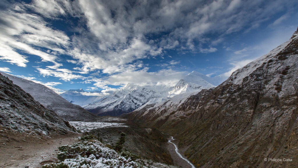
The West and Far West: Beyond the Annapurna range, the trail enters the remote and arid landscapes of Dolpo, Rara, and Humla. These areas are part of the rain shadow of the Himalayas, offering a stark contrast to the monsoon-heavy regions of the east.
The Central Ranges: The GHT traverses the Annapurna massif, Manaslu, the Ganesh Himal, and Rolwaling, where the landscape shifts from lush vegetation to alpine tundra.
The East: The trail moves through the Khumbu (Everest) and Makalu-Barun regions, characterized by deep valleys and the highest concentration of 8,000m peaks, before concluding near the base of Kangchenjunga.
Self-Sufficiency and Remote Travel
Traversing the GHT High Route requires significant logistical planning. While sections like the Everest or Annapurna regions offer established teahouses, much of the trail passes through uninhabited areas where self-sufficiency is mandatory. This involves managing multi-day food supplies, camping in rough conditions, and navigating terrain where trails are often faint or non-existent.
The most remote and wild segments are found in the Far West, Humla, and Dolpo, where infrastructure is minimal and villages are several days apart. In the east, the Makalu-Barun and Kangchenjunga regions present similar challenges due to rugged terrain and the absence of permanent settlements. Crossing high-altitude technical passes like the Sherpani Col or West Col requires total autonomy in glacial environments.
The GHT is a commitment to high-altitude endurance and self-sufficiency.
Humla Region
Running the GHT
The Idea
Anna and I envisioned a new project: running the high route of the Great Himalaya Trail. I aimed to cover the full 1,700km route in 40 days, while Anna planned to run 670km with me and provide essential logistical support for the remainder of the journey. Completing the route in this timeframe was the equivalent of running 40 marathons in 40 days (ten UTMB or seven Marathons des Sables).
We moved light and fast, carrying 10kg packs containing all our kit, gear, sleeping bags, and food. We did not carry a tent, bivy bag, or stove, choosing instead to use Esbit for heat or to eat cold food. At four specific locations, we met a support team for resupply. Throughout the entire journey, we operated without any guides or porters.
The Planning
We worked on this project for almost 18 months to gather all the necessary trail information. This involved dividing the route into relatively equal daily stages of 40km with 2,500m of positive elevation gain, and identifying bivouac spots, lodges when available, and the four resupply points.
Finding precise and reliable information for certain areas was a major challenge, particularly for the Kangchenjunga and Dolpo regions. Jamie McGuinness and Richard Bull provided invaluable assistance during this planning phase and in organizing the logistics. It was a pleasure to reconnect with Jamie after our Everest expedition and to meet Richard, who is also a passionate trail runner.
I eventually built a comprehensive roadbook including map copies, Google Earth imagery, distance and elevation profiles, and estimated crossing times for every pass and key waypoint along the 1,700km route.
We carried a GPS for safety, which we only turned on when in doubt, as we lacked the battery capacity to cover the autonomous zones. During the solo sections, I used a GPS tracker (Spot Messenger) and a satellite phone for safety and to send regular dispatches.
Kit List and R&D
At the time, we were athletes and consultants for Berghaus, who sponsored the crossing. During the eighteen months of preparation, we worked closely with their R&D teams to develop almost all the equipment used during the traverse: ultralight clothing, trail running packs, and a hydrophobic down sleeping bag that arguably saved my life during two nights in extreme conditions.
This collaboration was challenging given the fast-paced timeline, but also rewarding as two of the products developed were honored with ISPO Awards the following year.
Dolpo Region
The 34 days of GHT
Day 1 to 2: Simikot to Gamgadhi (Philippe)
At the end of September, Anna and I flew from Kathmandu to Simikot, a remote village in the Humla region. Our initial plan was to run together to Gamgadhi, but because the airstrip was closed, Anna ran the first 20km with me before returning to Simikot. I continued alone and reached Gamgadhi at the end of the following day, after losing the trail on several occasions.
Total for this section: 110km with 7,000m of positive elevation gain in two days.
Day 3 to 10: Gamgadhi to Kagbeni (Philippe)
I left Gamgadhi alone, carrying a 10.5kg pack with eight days of food, a sleeping bag, clothing, a medical kit, GPS, maps, and a Spot Messenger. The first day to Shilenchaura was straightforward; the Mugu Karnali river gorge is scenic, and the trail was relatively clear. However, the end of the day proved more difficult due to rain and a missing bridge over the Karnali River.
The second day was demanding from the start. As I carried neither a tent nor a bivy bag, I had sought shelter under large boulders to stay dry during the night. Lacking a tent, I had no physical protection from wildlife. A wolf stayed near my bivouac and followed me for a distance the next morning. Although the encounter was unsettling, I knew that they usually circle out of curiosity rather than to attack; nonetheless, I remained focused on the wolf’s position.
The trail eventually disappeared, and I struggled to navigate through landslides, rockfalls, and scree slopes. The weather remained poor, with a mix of rain, snow, and wind. Since I had no stove—only fuel tablets which failed to ignite in the wet conditions—I had to rehydrate my freeze-dried meals with cold water and was unable to prepare any hot drinks. After fourteen hours of effort, I crossed the Chyargola La (5,151m) and camped by a river further down the valley.
Dolpo Region
Yala La (5,415m) and Nyingma Gyansen La (5,565m)
Day 5. I had significant doubts regarding the Yala La, as I had heard that the maps were inaccurate and the pass was actually located several kilometers further north. With 10cm of fresh snow, finding the faint trail was difficult. As expected, the ridge crossing was not where it was marked on the maps, but the route followed a logical line that avoided a zone prone to rockfalls.
Relieved, I descended into the Swaksa Khola, a wild and remote valley. Suddenly, upon reaching a ridge top, I came face-to-face with two white wolves. Since I was upwind and concealed by the ridge, they had not detected my presence. They were as surprised as I was, but reacted quickly and ran off before I could reach for my camera. Despite the missed photo, it was a significant encounter.
The day was long, and I was unable to cover the planned distance. While climbing toward the Nyingma Gyansen La, I found a small cave and decided to bivouac there for the night.
After crossing the pass, I reached the ridge feeling relieved, knowing I was approaching Pho, one of the few villages in this region. However, this relief led to a lapse in concentration, and I mistakenly descended into the wrong valley, likely following an old yak trail. I had to climb back up, exhausted and frustrated, finally arriving at the small hamlet of Pho a few hours later. They were the first people I had seen in several days.
I had hoped to buy supplies or snacks in the village, but I quickly realized there was nothing available. The village is remote; the residents did not speak English, there were no shops, and food was scarce. Seeing my condition, some inhabitants offered to share their meager meal. Although I was starving, I knew their limited reserves had to last them through the winter; I politely declined and continued on my way.
I crossed the Tora Khola river below the village, which features a deep gorge with red rocks and turquoise water, before finally finding a spot for the night’s bivouac.
Day 7, leading to the village of Khoma, covered 51km with 2,800m of ascent. Both the trail and the weather improved significantly. I bivouacked near Khoma.
Day 8 was more manageable, allowing me to run 60km. The main challenge of the day was crossing a powerful river just below the camp. The current was strong and the water was too deep to wade across. A fallen tree trunk spanned the river, but it was covered in ice. I ended up crawling across the trunk, terrified of slipping into the torrent which would have been fatal.
Mola Bhanjyang (5,030m)
Day 9 began with a new snowstorm that lasted until I reached the Mola Bhanjyang (5,030m). The weather improved as I passed through the village of Chharka Bot, where I was able to buy some biscuits. I continued for another 21km to reach my bivouac at Nulung Sumdo, situated at an altitude of 5,000m.
Dolpo Region
Jungben La (5,550m) and River Crossing
It snowed during the night, and I woke up with 5cm of fresh snow on my sleeping bag.
I crossed two passes: Jungben La (5,550m) and Jungbenley La (5,120m).
Crossing the river between Ghok and Santa was a significant challenge; aside from a few yak and mule tracks, the trail was non-existent. While the river itself was not difficult to ford, the gorge is deep and subject to constant rockfalls. I hoped to cross quickly and climb the opposite slope to reach safety, but I could not find the path up.
I went back and forth along the valley floor, searching in vain for a trail and jumping at every sound of falling rocks. My GPS could not get a signal in the narrow gorge, and I struggled to find a logical route between the rock faces and large scree slopes.
After several attempts, I spotted some old, dried mule dung. I followed my intuition and tracked it, eventually rediscovering a faint path 300 meters higher up. I was physically and nervously exhausted, yet the day was far from over.
Even after Santa, the trail to Kagbeni through the fog seemed endless. It was only late at night that I finally met Anna and Richard in Kagbeni.
These few lines are only a brief summary of what I experienced during this Dolpo traverse.
Total for this section: 370km with 19,360m of positive elevation gain in 8 days.
Meeting with Anna in Kagbeni
Upon reuniting with Anna, I was overwhelmed by emotion and joy. Despite the late hour, the adventure was set to continue the following morning with the crossing of the Annapurna circuit.
Fortunately, she had already prepared the next steps, allowing us to set off again after only a short night of sleep.
Day 11 to 18: Kagbeni to Syabru Besi (Anna and Philippe)
Anna and I left Kagbeni early in the morning, starting the day with a continuous 2,600m climb to the famous Thorong La (5,416m). We reached the pass during a snowstorm and continued down the other side to Yak Kharka, where we spent the night in a lodge.
It snowed throughout the night, and we left the lodge the next morning with an amazing view of the snow-covered Annapurnas. This day was relatively easy in terms of ascent, but we covered 57km in distance, ending the day in a lodge in the village of Lata Marang.
Manaslu Region and Larkya La (5,150m)
Day 13 went well, with clear weather throughout the day and amazing views as we transitioned from the Annapurna region to Manaslu. We ran all the way to Bimthang, a beautiful location with several lodges surrounded by mountains.
We left Bimthang before sunrise for a 60km day, first climbing the Larkya La (5,150m), which offers some of the most stunning views on the Manaslu circuit. After the pass, we began a long descent, passing through several villages: Samdo, Sama Gaon, Lho, and Namrung.
Annapurna Region
Ganesh Himal
Day 15 was one of the longest in terms of distance, covering 63km. The trail was hot, long, and demanding; Anna and I arrived just after nightfall at a basic lodge, notable for its giant spiders. The following day was no easier as we left the Manaslu region to enter the Ganesh Himal.
The landscape changed significantly, becoming greener and hotter, with far fewer trekkers. We struggled to find the trail and lost our way several times on the route to Myangal Kharka, eventually reaching Lapagaon after 14.5 hours of effort.
Syabru Besi - Half Way of the GHT
On day 17, we moved up and down all day, covering 46km with 3,600m of ascent. At these lower altitudes—ranging from 1,600m to 3,840m—the weather was hot and humid. We struggled to find food, managing only to find some boiled potatoes in Tipling, and eventually spent the night in a lodge at Somdang. Unfortunately, I suffered severe food poisoning there after eating spoiled meat.
On day 18, I could barely stand. Despite the relatively short distance of 33km, reaching Syabru Besi was grueling. I spent eight hours crawling more than walking, supported by Anna, who carried part of my pack. We met Richard in Syabru Besi, who brought a supply of chocolate.
At this point, Anna and I had completed half of the Great Himalaya Trail in eighteen days, ahead of our original schedule. However, we received the news that a Category 5 cyclone (Cyclone Phailin) had begun to hit Nepal.
Total for this section: 390km with 19,360m of positive elevation gain in 10 days.
Manaslu Region
Day 19 to 25: Syabru Besi - Tilman Pass - Katmandu (Philippe)
Kyanjing Gompa and Cyclone Phailin
On Day 19, Anna returned to Kathmandu and flew to the Everest region to wait for me and prepare the logistics. Rich and I started the long walk to Kyanjing Gompa in the Langtang region under the heavy rain of Cyclone Phailin. I was still weak from the previous days of illness but managed to keep going. We spent the night in a lodge at Kyanjing Gompa.
On Day 20, the cyclone continued to drop heavy snow and rain. Rich headed back down to Syabru Besi and then to Kathmandu.
On Day 21, the snowfall persisted; a few people attempted to climb nearby summits but were forced to turn back due to waist-deep snow. I remained at Kyanjing Gompa, waiting for the weather to improve.
On the Way to Tilman Pass (5,315m)
The weather improved the following day. I left Kyanjing and struggled to cross the Langtang Khola (river), which had become a powerful torrent after the heavy rain. The deep snow above 4,000m slowed my progress considerably, and I was forced to set up camp at a lower altitude than planned.
On Day 23, I continued toward Tilman Pass (5,315m). The conditions were treacherous, marked by avalanches and deep snow. I broke trail alone for hours, eventually reaching 5,000m.
Alone on the way to Tillman Pass after the Cyclone
Cyclone Phailin: Breaking Point at 5,000m
At 5,000m, the snow was chest-deep, and I was exhausting myself breaking trail, advancing at only 70 meters of altitude per hour. At times, the snow was so deep that I tried to crawl on the surface instead of wading through it. Avalanches were occurring nearby, even though I avoided the most exposed slopes. A small voice in my head told me it was over—that I had no chance of crossing Tilman Pass, and that even turning back safely would be difficult.
Regardless of the cyclone, Tilman Pass had always been a major uncertainty of this GHT: limited information was available, the other side was known to be technical, and the region was remote with no villages. With the effects of the cyclone, it was impossible to know how far the snow line reached on the opposite side or if the trails still existed. Devastated, I decided to turn back.
However, turning back did not immediately solve the problem. Due to the warmth, avalanches began coming down—I counted about ten per hour of various sizes. My ascent tracks were now in the sun and too exposed. Since I was already soaked, I decided to descend through a torrent, alternating between wading through waist-deep water, navigating lateral moraines, and sliding through the snow whenever possible.
Once below the snow line, I called Anna to tell her I was safe and heading back to Kyanjing. I was alive but demoralized—more because of the risks I had taken than because of the setback itself. I arrived in Kyanjing exhausted very late that night.
Back to Reality
Back in Kyanjing, I realized the full impact of the cyclone: many people had died in avalanches, most expeditions had either left or been evacuated, and two meters of snow had fallen above 5,000m, closing all high passes. It would take days, or even weeks, for the snow to stabilize, meaning there was no hope of crossing Tilman Pass or Tashi Labsta anytime soon.
Anna and I decided to change our approach: I returned to Kathmandu, flew to Lukla, and joined her in Namche Bazaar. From there, we planned to climb Island Peak (6,189m), and then attempt to follow the GHT from Chhukhung to Chhechet (east to west). We hoped that snow conditions would improve enough to allow us to cross the high passes in that direction.
On Day 25, I was in Kathmandu reorganizing the logistics and the Island Peak expedition with Jamie and Rich.
Total for this section: 122km with 5,300m of positive elevation gain in 6 days.
Katmandu to Namche Bazar
On Day 26, I left Kathmandu, flew to Lukla, and walked straight up to Namche Bazaar, where I reunited with Anna and Pasang Gumbu. Reuniting with Anna was again an intense moment.
I was also very happy to see Pasang Gumbu again, following our Everest and Makalu expeditions. Always enthusiastic, he was excited to join us for Island Peak and to attempt a trail crossing of the Khumbu region. The idea of climbing Island Peak was a bit unconventional given the circumstances, but since completing the original GHT route was no longer possible, we decided to make the most of the situation by summiting a peak.
Khumbu Region, Lhotse
Day 27 to 34: Lukla to Chhetchet (Anna and Philippe)
On Day 27, Anna, Pasang, and I moved up to Chhukhung. On Day 28, there was still too much snow to attempt Island Peak, so we had to wait another day in Chhukhung for conditions to stabilize. On Day 29, we moved up to the Island Peak base camp.
On Day 30, Pasang and I summited Island Peak, becoming the first to reach the top that season. Due to the challenging conditions, there were only ten climbers on the peak, which is highly unusual for this mountain. Afterward, Anna, Pasang, and I descended to Dingboche.
Cho La (5,330m) and Renjo La (5,334m) in Deep Snow
On Day 31, we traveled from Dingboche to Gokyo, crossing the Cho La (5,330m) in deep snow.
On Day 32, we continued from Gokyo to Thyangbo, located above Thame.
Once again, the snow was deep and soft above 4,500m, and crossing the Renjo La (5,334m) was exhausting. In over ten years, I had never seen so much snow in the Khumbu. The region was unrecognizable and nearly deserted.
Tashi Labsta (5,755m) to the Finish
On Day 33, crossing the Tashi Labsta (5,755m) was a true mission. The snow was still deep on the pass, and the nine kilometers of glacier and moraine were beyond imagination. Starving and exhausted, my body reached its limit; I simply could not move forward.
Once again, we did not have enough food, sharing only a few bars during hours of intense effort. Anxious, Anna followed in my footsteps, supporting me as best as she could. We finally made it off that moraine, only to be welcomed by a new snowstorm. We eventually reached the hamlet of Na after 14 hours of effort.
On the final day, we descended from Na to Chhechet, completing the last kilometers of our Great Himalaya Trail journey under heavy rain and thunderstorms. From Chhechet, a Jeep took us back to Kathmandu, where we spent the next few days resting and eating.
Total for this section: 225km with 11,300m of positive elevation gain in 9 days.
On the way down from Tashi Labsta (5,755m)
Information
Final Statistics and Reflections
In total, we covered 1,220km with 61,150m of vertical gain over 30 days. This represented a daily average of 41km and 2,038m, frequently at altitudes above 4,000m and reaching up to 6,189m.
In retrospect, this pace was clearly excessive. However, it might have been sustainable had the weather conditions remained standard and the trails—particularly in the Dolpo—been more passable. Given our objective to complete the GHT in under 40 days, our options were limited.
Ultimately, while meticulous planning of stages, trails, and bivouac sites is essential, it is the actual conditions on the ground that dictate the outcome. In the end, only experience allows you to face and adapt to these realities.
Autumn Climate & Optimal Window
The autumn season in the Himalayas is the preferred window for a GHT crossing, defined by the transition between the retreating summer monsoon and the onset of winter.
Post-Monsoon Stability: Typically starting in late September, the retreating monsoon leaves behind clear skies and atmospheric stability. This provides the visibility required for technical navigation over high-altitude passes.
Optimal Timing: The ideal window falls between October 1 and November 15.
- October: Favorable balance of temperate valley weather and clear high-altitude views.
- Early November: Dry but significantly colder; the final safe window before winter snows block the passes.
Temperatures and Risks: While daytime trekking is comfortable, night temperatures at high camps frequently drop to -15°C. The primary weather hazard remains late-season cyclonic activity, which can unexpectedly lead to heavy snowfall and significant avalanche risks.
Strategic Direction: East-to-West vs. West-to-East
Choosing the direction of a GHT crossing is a strategic decision dictated by the sun, the snow line, and the seasonal progression of the monsoon.
The East-to-West Advantage (E-W): This is a common choice for autumn expeditions. Starting in the east allows for traversing the humid Kanchenjunga and Makalu regions just as the monsoon retreats, moving toward the drier, high-desert landscapes of Dolpo and Mugu as the season stabilizes. This direction generally offers a favorable weather window for the high-altitude desert sections.
The West-to-East Challenge (W-E): Traveling west-to-east often involves moving toward the Everest and Kangchenjunga regions as winter approaches, increasing the risk of deep snow on technical passes like the Three Passes. Late-season storms can deposit significant snow, making these high-altitude crossings difficult or impossible.
Our Strategy: The West-to-East Direction
While an east-to-west route is often suggested, it presents a significant hurdle early in the season: the high passes of the east—specifically the Three Passes—are frequently still blocked by winter snow and are effectively closed to fast-moving expeditions.
To avoid being blocked in the east at the start, the west-to-east direction was selected. This strategic shift turned the expedition into a race against the winter. The objective was clear: complete the 1,700km crossing in under 40 days to clear the technical high-altitude terrain before the autumn window closed.
The Risk: being caught by early winter storms that can deposit large amounts of snow on the final, most technical passes of the journey.
Analysis: Gear & Nutrition Strategy
Each of our packs weighed approximately 8kg (excluding food and water). Overall, our gear choices were sound, though the “light and fast” philosophy required compromises and sacrifices in comfort.
For nutrition, I applied my experience from desert ultra-marathons, targeting 3,700 calories per day (roughly 4.8kg for a seven-day stretch). However, we identified two major flaws in our plan:
- Over-reliance on local supply: We counted too much on finding food in villages. While feasible in popular trekking zones, it proved nearly impossible in remote areas like the Dolpo.
- Daytime calorie deficit: I had planned to stop for a freeze-dried meal at noon. In reality, the ten to twelve hours of daily running left no time for breaks. Eating only in the evening led to chronic hypoglycemia during the day.
Ultimately, the severe protein deficiency and calorie gap resulted in significant weight loss and muscle wasting by the end of the journey.
Pack and Sleeping System
- Backpack: 37L ultralight pack.
- Bivouac: Sleeping bag, foam mat, and bivy bag.
- Hydration: 2L hydration reservoir.
Apparel and Layers
- Insulation: Technical long-sleeve zip shirts, hooded insulated jacket, hybrid mid-layer, and lightweight insulated jacket.
- Weather Protection: Ultralight windshirt and waterproof overtrousers.
- Lower Body: Running shorts and technical tights with side pockets.
- Head and Hands: Running gloves, hardshell mitts, powerstretch gloves and hat, mesh cap, and neck gaiters (warm and light versions).
- Footwear: Trail running shoes, technical running socks, and trail running gaiters.
Technical and Safety Gear
- Navigation and Comms: GPS, maps, satellite messenger (Spot), and satellite phone.
- Hardware: Trekking poles, head torch with spare batteries, two pairs of sunglasses, and a knife.
Health, Hygiene and Electronics
- Kitchen: Compact stove (Esbit), food supplies, electrolytes, vitamins, and utensils.
- Personal Care: Medical kit, emergency blanket, sunblock, and basic hygiene kit.
- Electronics: Cameras (with spare batteries and cards) and MP3 player.