Nepal
From Annapurna to Everest
Located in the heart of the Himalaya, Nepal stretches across a narrow strip of land between India and the Tibetan plateau. This geographical location explains the remarkable diversity of its landscapes, climates, and natural environments. For outdoor enthusiasts, the country offers an exceptional playground, from subtropical valleys to the highest peaks on the globe. Between the Annapurna and Everest massifs, a succession of valleys, passes, and high plateaus form a unique ensemble, perfect for trekking, mountaineering, and trail running.
The Annapurna region is characterized by a dense network of trails connecting villages, agricultural areas, and high-altitude forests. The famous Annapurna Circuit traverses very contrasting environments, passing from humid, cultivated zones to mineral landscapes dominated by high walls. The passes, notably the Thorong La, mark distinct transitions between the southern slopes and the more arid zones of Mustang. This geographical variety allows one to experience a wide palette of climatic conditions and terrains in a short time.
Heading east, the Manaslu and Langtang regions offer a progressive transition towards the great massifs of the central Himalaya. Less frequented, they are distinguished by deep valleys, rhododendron forests, and high-altitude plateaus dominated by soaring peaks. These sectors retain a more isolated character, where routes often follow ancient trade roads connecting Nepal to Tibet.
The Everest region, accessible mainly via the Khumbu Valley, is the kingdom of high mountains. Around Sagarmatha, the Nepali name for Everest, trekking routes are organized leading to natural viewpoints, glaciers, and base camps. The high altitude imposes a measured progression, paced by acclimatization phases. Sherpa villages, established on moraine flats, structure human settlement and testify to an ancient adaptation to these demanding environments.
Himal Race
1,000km Ultra-trail
The Himal Race is a unique race that starts from Annapurna Base Camp, crosses the Himalaya, and ends at Everest Base Camp. The course covers a distance of 1,000km with 80,000m of positive elevation gain, to be completed in 23 days.
For professional reasons, I could only complete the first twelve stages of the traverse, from the Annapurna Sanctuary to Trisuli Bazar, totaling 605km and 46,000m of elevation gain.
These twelve days actually correspond to a combination of several emblematic treks linked one after the other: the Annapurna Sanctuary, the Annapurna Circuit, the Manaslu Circuit, and the Gosainkund trek, which are usually covered in about sixty days.
I then returned to France with Anna, while the other runners continued the race to Everest Base Camp.
We keep a magnificent memory of the Himal Race for its atmosphere, the people we met, and this unique experience of running in Nepal. Since then, the kilometers have accumulated, leading to our traverse of the Great Himalaya Trail.
Knights of the Wind
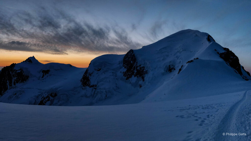
Although I already knew Nepal and Tibet from previous expedition to Cho Oyu (8,188m), this was the first time we ran in Nepal. It was also our first meeting with the “Chevaliers du Vent” (Knights of the Wind) team, Bruno Poirier and Jean-Marc Wojcik, whom we later met again during the Everest Sky Race, as well as on expeditions to Ama Dablam and Kangchenjunga for Jean-Marc.
The Himal Race Rules
That is what I appreciate about Bruno: the rules are intentionally simple. A starting point, a finish line, sometimes a checkpoint, and total freedom in the choice of route.
The race is self-supported, which implies that each runner carries all their equipment. This includes a sleeping bag, clothing, medicine, technical gear (light rope, carabiners, crampons), energy bars, a stove, and about 3,000 calories of survival food. In total, the backpack weighed nearly 9.5 kg, not counting water.
Himal Race Story
Trek to the Annapurna Sanctuary (October 28-30)
Naya Pul (1,100m) – Machhapuchhre Base Camp (3,800m)
55km, +4,000m / -1,300m
We spent these three days hiking to the Machhapuchhre Base Camp, the starting point of the race. This trek played an essential role in acclimatization, although it was demanding, as we reached the base camp in two and a half days instead of the usual six. Three runners chose to skip this walk to go directly to Tadapani. Regardless, the route offered a great variety of landscapes, from the rice fields of Naya Pul and Ghandrung to the forests of Dobang and the surrounding high peaks.
Stage 1 (October 31): Machhapuchhre Base Camp (3,700m) - Annapurna Base Camp (4,100m) - Tadapani (2,700m)
50km, +2,035m / -3,050m, 7h52
At 4 a.m., we were all eager to start this first stage. However, getting out of the sleeping bag proved difficult. The temperature was around 3°C inside the lodge, and the night spent at 3,700m had not been comfortable.
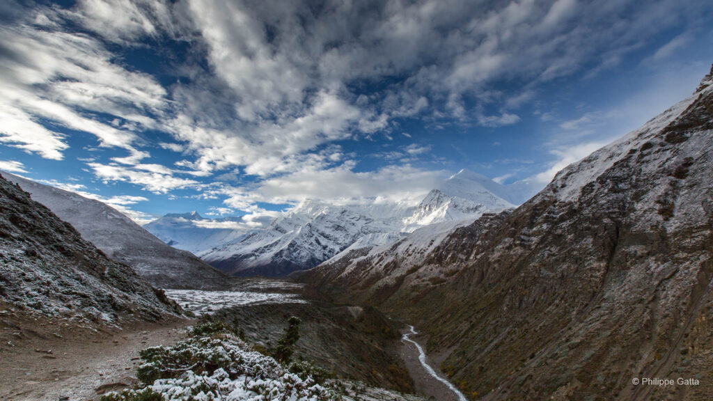
At 6:30 a.m., we arrived at Annapurna Base Camp, the official start of the race. The sun was rising over Annapurna I (8,091m), Bahara Shikhar (7,647m), and Machhapuchhre (6,993m).
The race then began. Despite the 50km of this stage, the cold, the altitude, and the snow on the ground, the pace quickly resembled that of a half-marathon, far from what one might imagine for a 1,000km event.
By 11 a.m., we had descended below 2,500m, into the vast forest of the Annapurna Sanctuary. The climb towards Chomrong and its 400m of stairs proved grueling. The temperature exceeded 30°C, marking a striking contrast in less than four hours.
The last few kilometers were both superb and exhausting. I descended to 1,800m at Chule, before climbing back up to 2,700m. I struggled to realize that we were moving through a tropical forest populated by monkeys, whereas we were walking on the Annapurna glacier just a few hours earlier.
After a shower, I spent the rest of the day washing my clothes, stretching, and resting. The first runner completed the stage in 4h52, the last in 10h48, and one participant dropped out.
Stage 2 (November 1): Tadapani (2,700m) - Poon Hill (3,200m) - Dana (1,450m)
40km, +1,460m / -2,535m, 5h55
Total: 90km, +3,495m / -5,580m
After a few kilometers in the tropical forest, I reached the ridge between Tadapani and Ghorepani. The weather was clear, the temperature pleasant, and I could enjoy a panorama stretching from Dhaulagiri (8,167m) to the Annapurna range. The trail alternated between climbs and descents before plunging towards Ghorepani, then climbing up to Poon Hill.
I passed the checkpoint at the summit of Poon Hill, before starting a continuous descent of nearly 2,000m. Around noon, with Mikael Delonglee and Pasang Sherpa, we thought we were minutes away from the finish. Unfortunately, we confused the villages of Tatopani and Dana: there were still 6km and 300m of elevation gain to cover. The heat and the 10 kg backpack made this end of the stage grueling.
After these long descents, many runners complained about their knees and dreaded the next three days, during which we had to climb from 1,400m to 5,400m altitude.
The winner finished the stage in 4h14, the last in 13h39. Several runners received a four-hour penalty for skipping the Poon Hill climb.
Stage 3 (November 2): Dana (1,450m) - Marpha (2,670m)
45km, +1,600m / -305m, 5h59
Total: 135km, +5,095m / -5,885m
I left Dana, its apple and orange trees, to return to the mineral world of high altitude. Above Dana, the valley became narrower and deeper. The trail, steep and devastated every year by the monsoon, had to be constantly maintained.
Above Kalopani, the landscape became mineral and desert-like, reminiscent of Tibet. At Sokung, I left the trail to take a shortcut by staying closer to the river. It was shorter, but it forced me to cross the current several times, with water up to my chest. This choice ultimately did not prove wise. I finally reached Marpha, where I reunited with Anna, who had shortened the first stages.
Winner: 4h33, last: 9h15.
Stage 4 (November 3): Marpha (2,670m) - Kagbeni - Muktinath (3,700m)
25km, +1,115m / -150m, 4h05
Total: 160km, +6,210m / -6,036m
This was the shortest stage of the race. We passed through Kagbeni, at the northern end of the Annapurna trek. Further north lay the restricted province of Mustang. We branched off east to begin the steep climb leading to Muktinath.
Winner: 2h50, last: 6h15.
We spent the day of November 4 in Muktinath to rest, continue our acclimatization, and do some cleaning.
Stage 5 (November 5): Muktinath (3,700m) - Thorong La (5,416m) - Khangsar (3,800m)
45km, +2,240m / -2,135m, 8h37
Total: 205km, +8,450m / -8,170m
For some runners, this was a first experience of high altitude. We left Muktinath at 5 a.m. to progress slowly towards the Thorong La pass (5,416m). We reached it before 10 a.m., where Maryse Dupré and Jean-Marc Wojcik, doctors and runners, checked our oxygen saturation. Mine was 67%.
I then started running towards the village of Khangsar, but not for long: above 5,000m, the effort quickly became too taxing. I spent most of this stage with Patrick Rolland and Yves Detry, discussing mountaineering while contemplating the Annapurna range and Tilicho Peak (7,134m) facing us.
Around noon, we crossed the Jhorgeng river and began the climb towards a small pass leading to Khangsar. I was relieved to see this village and enjoy a hot lemon there after eight hours of running.
Winner: 6h36, last: 14h.
Stage 6 (November 6): Khangsar (3,800m) - Tilicho Lake (5,100m) - Manang (3,350m)
40km, +1,955m / -2,405m, 8h52
Total: 245km, +10,405m / -10,575m
We left Khangsar early in the morning to climb towards Tilicho Lake, during another stage above 5,000m. For several kilometers, the trail stayed around 4,000m, traversing sandy slopes before becoming much steeper below the lake. Above 5,000m, the route was snow-covered. The view of the Great Barrier of Annapurna, Tilicho Lake, and Mesokantu La was striking.
I passed the checkpoint, then started the descent towards Khangsar. I stopped briefly there to eat soup, before continuing towards Manang.
Winner: 5h35, last: 11h. Three runners did not start and three others did not reach Tilicho.
Stage 7 (November 7): Manang (3,350m) - Gharyu (3,670m) - Lata Marang (2,450m)
50km, +820m / -1,910m, 6h47
Total: 295km, +11,225m / -12,485m
After three days spent at high altitude, I was happy to be back in the forest. We passed through Gharyu, quickly reached Pisang, then continued towards Lata Marang.
Winner: 4h32, last: 9h36. Anna, Marie-Jeanne Simons, and Patrick Rolland left the race to return to Kathmandu, while the rest of the group continued towards the Manaslu Circuit.
Stage 8 (November 8): Lata Marang (2,450m) - Dharapani (1,950m) - Bimtang (3,800m)
40km, +2,050m / -790m, 6h03
Total: 335km, +13,275m / -13,265m
The first part followed a forest trail. We left the Annapurna Circuit at the Dharapani checkpoint to head towards the Manaslu Circuit. We started with a 2,000m climb towards Bimtang. The scenery was reminiscent of the Alps, apart from the height of the peaks. The weather deteriorated, forcing us to speed up to reach the lodge before the storm.
The tiny village of Bimtang (3,800m) consisted of only three or four dilapidated houses where we spent the night. Comfort was rudimentary: four stone walls, a wooden roof, and a single room serving as both kitchen and dormitory. There was no electricity, no running water, and no toilets. Food was stored on the floor, with meat hanging from the walls. I felt like I had gone back four centuries. Too tired to be picky, I ate everything I could before going to bed. The wind blew through the cracked walls and it was snowing outside.
Stage 9 (November 9): Bimtang (3,800m) - Larkya La (5,200m) - Sama Gaon (3,500m)
40km, +1,540m / -1,700m, 7h31
Total: 375km, +14,815m / -14,965m
Due to fresh snow, the organization decided to keep us together until the Larkya La pass (5,200m), where the stage start was given. We checked our oxygen saturation again at the pass, with a rate of 70% for me, before starting the descent towards Sama Gompa, which I reached two hours later with Gilles Rostollan. An hour and a half later, we were at Sama Gaon.
Winner: 6h36, last: 10h10.
Stage 10 (November 10): Sama Gaon (3,500m) - Jagat (1,250m)
70km, +1,300m / -3,400m, 9h07
Total: 445km, +16,115m / -18,365m
We knew this 70km stage would be grueling. The sun rose over Manaslu (8,156m) shortly after the start. The stage began in a dense forest along the river. We then left the forest to follow a steep trail overlooking the valley, 300 meters below. Climbs and descents followed one another for several kilometers. The temperature rose as we lost altitude. I joined Emmanuel Villeneuve, and we helped each other until the end of this demanding stage.
Winner: 7h32, last: 13h40. Eddy Kern and Philippe Boyer did not finish the stage.
Stage 11 (November 11): Jagat (1,250m) - Arughat Bazar (500m)
60km, +1,160m / -1,910m, 6h46
Total: 505km, +17,275m / -20,275m
Upon waking up, the news was not good: Vincent Chautard had knee pain, Pascal Beaury and Francis Faure had numerous muscle pains. We had no news of Eddy Kern and Philippe Boyer, who must have spent the night in a small village a few kilometers up. This stage proved as difficult as the previous one, with 60km to cover and a damaged bridge making the river crossing tricky. Furthermore, we had been advised to remain vigilant regarding the risk of Maoist attacks along the route.
Thirty minutes after the start, the trail disappeared. I struggled to find my way and cross the river. I fell into the water and finally managed to cross, very annoyed.
Halfway through, the path split. The map proved very inaccurate and, after several mistakes and useless kilometers, I finally found the right route. A few kilometers further, I crossed the broken bridge without too much difficulty, but the stage seemed endless. I crossed numerous villages and rice paddies before finally reaching Arughat Bazar.
Winner: 5h06, last: more than 12h.
Stage 12 (November 12): Arughat Bazar (500m) - Trisuli Bazar (540m)
55km, +1,740m / -1,670m, 8h30
Total: 560km, +19,045m / -21,945m
We left as a group, looking for the right trail towards Trisuli Bazar. The climate and landscape differed radically from anything we had crossed so far. It was very hot, with humidity close to 100%, and a thick fog covered the valley.
As we progressed through the misty rice fields, some were whistling the tune from The Bridge on the River Kwai or Apocalypse Now, almost expecting helicopters to appear to the sound of Ride of the Valkyries.
A few hours later and 900m higher, I reached the first pass of the day. I thought this stage would be relatively flat, but it was not.
There were almost no tourists in the region and it was impossible to buy mineral water or soda. Drinking water from the villages would have been risky; so I only drank one and a half liters in over eight hours of running. I arrived in Trisuli totally dehydrated.
The curfew started at 7 p.m. The roads were deserted, shops closed, and windows locked for this second day of general strike. Despite the ambient tension, the atmosphere within the group remained excellent, perhaps even a little too much: while we were making noise, soldiers banged on the door. About thirty of them entered, Kalashnikovs in hand, to firmly ask us to be quiet. We slept in cramped and dirty rooms, while tropical rain hammered the tin roofs with a deafening noise. These were ideal conditions for recovering during an ultra-trail.
As planned, the race ended here for Maryse Dupré, two other runners, and myself. Due to the general strike, we had to stay in Trisuli Bazar until November 14, before returning to Kathmandu in a small bus. I was sad not to be able to continue towards Everest.
Informations
Climate
In autumn, from mid-October to late November, the regions from Annapurna to Everest generally enjoy stable and dry weather conditions. The monsoon has just ended, giving way to often clear skies, excellent visibility, and moderate temperatures in the valleys. Days are sunny, while nights become cool starting at 2,000 meters and cold at high altitude. These conditions make autumn the most favorable period for hiking, trail running, and mountaineering.
However, thermal contrasts remain marked. In a few hours, one can go from a hot and humid atmosphere in the lower valleys to a clearly colder and windier climate above 4,000 meters. Night frosts are frequent at altitude, and the first snow episodes can appear on high passes.
Race Organization
The organization was excellent, with a team of sixty people in charge of logistics, managing stage starts and finishes, as well as checkpoints. Two runners were also doctors and three others specialized in rescue techniques.
That said, it is a committed race: trails in the Himalaya are not like those found in Europe, some areas are very isolated, and rescue is almost non-existent. Experience in high mountains, long traverses, and solidarity between runners are fundamental.
We spent most nights in lodges, comfort varying by region. Food-wise, it was much more complicated, as it is difficult to find the necessary quantity and quality for repeated efforts over several weeks. There are generally not too many problems in tourist areas, but it becomes problematic in some more remote regions. We encountered the same difficulties and deficiencies during the GHT and, to a certain extent, during the ViA Alpina. We later tried to limit these deficiencies by taking high-protein powders and vitamin and mineral supplements.