Kangchenjunga (8,586m)
Introduction: The Untamed Giant of the East
Standing at the far eastern edge of the Himalaya range, Kangchenjunga is a sacred mountain. Straddling the border between Sikkim (India) and eastern Nepal, its name translates to “The Five Treasures of the Snows.” At an elevation of 8,586m (28,169 ft), it is the third-highest mountain on Earth, after Mount Everest and K2.
Despite its scale, Kangchenjunga remains one of the least-visited 8,000-meter peaks. Among the fourteen peaks exceeding 8,000 meters, it is the second least climbed. Statistically, only Annapurna has recorded fewer successful ascents. This is due to the mountain’s remote location, unpredictable weather, and the technical difficulty of the upper slopes.
The history of its exploration reflects these challenges. Since the first ascent in 1955, the summit has remained a difficult objective. To put this into perspective: while over 4,500 people have summited Mount Everest, only 243 had reached the summit of Kangchenjunga at the time of our expedition. It is a mountain that demands significant commitment and self-reliance.
For the French mountaineering community, Kangchenjunga has been a source of both triumph and tragedy. Before our expedition, only three French climbers had reached the summit: Michel Parmentier and Jean-Jacques Ricouard in 1981, and Pierre Beghin in 1983. In 1995, the mountain took a heavy toll when Benoit Chamoux and Pierre Alain Royer disappeared on the North Face. It took 28 years before two more Frenchmen, Philippe Gatta and Ludovic Challéat, would reach the summit.
Swiss climbers have also established a record on this peak. Prior to our mission, nine Swiss mountaineers had reached the top, including Erhard Loretan, for whom Kangchenjunga was the final peak of his 14x8000er quest in 1995. Following our expedition, Cédric Hahlen became the 10th Swiss climber to reach the summit.
Kangchenjunga Historic Timeline
An expedition led by occultist Aleister Crowley attempted the Southwest Face. They reached 6,500m before a tragic avalanche forced them to abandon the climb.
British climbers Joe Brown and George Band completed the first successful ascent. Out of respect for local beliefs, they stopped a few feet short of the actual summit, a tradition still honored by many today.
Doug Scott, Peter Boardman, and Joe Tasker completed the first ascent without supplementary oxygen. They achieved this revolutionary feat via a new route on the North Ridge in lightweight alpine style.
Legendary French climber Pierre Beghin achieved the first solo ascent of Kangchenjunga, without supplementary oxygen, via the Southwest Face.
Polish alpinists Krzysztof Wielicki and Jerzy Kukuczka reached the summit on January 11th, marking the very first successful winter ascent of this giant.
Swiss climber Erhard Loretan reached the summit, becoming the third person in history to complete the ascent of all fourteen 8,000m peaks.
British mountaineer Ginette Harrison became the first woman to stand on the summit, after many years of unsuccessful attempts by various female expeditions.
The Expedition
The Team
The French-Swiss team was omposed of Ludovic Challeat, Alexia Zuberer, Régine Tornay, Benoit Rosset, Jean-Marc Wojcik, Cédric Hahlen, Gorgan Wildberger, Pemba Sherpa and Philippe Gatta. Anna Gatta joined the Team up to the base camp of Kangchenjunga and returned via the North circuit and the three passes: Sinelapche La (4,650m), Mirgin La (4,585m) and Selele La (4,210m).
The Trek to Kangchenjunga Base Camp
The Kangchenjunga region is incredibly wild, with almost no trekkers or lodges. Overall, the trek is much more demanding than those in the Annapurna or Everest regions. There is no support infrastructure for trekkers, porters are very difficult to find, and the route involves significant elevation changes, ranging from 700m to 5,500m.
April 9: Katmandu - Tharpu (1,300m)
We flew from Kathmandu to Bhadrapur in the morning. After collecting our gear, which had arrived the previous day by truck, we traveled by 4-wheel drive toward Tharpu. We gained altitude quickly, passing through Ilam, and reached 2,500m before the road descended and climbed again. We eventually left the main road for a muddy track. Torrential rain fell and lightning was frequent. We reached Tharpu late in the evening after an 8h 30m drive.
April 10: stuck at Tharpu (1,300m)
Unfortunately, the 40 porters assigned to carry our gear were not present. Some were delayed coming from Taplejung because the road was closed by a major landslide. A few others had arrived but were unable to work following an incident that led to hospitalizations and arrests. As a result, we spent the day waiting, hoping for more porters to arrive by evening.
April 11: Tharpu (1,300m) - Doban (1,020m)
Some porters arrived, but not enough to carry all our equipment, so we decided to set off with only the essential kit for the trek. Pemba stayed behind in Tharpu to hire more porters for the remaining gear.
We finally left Tharpu at 9:00 AM under clear skies and mild temperatures. We first descended to the river at 720m, the lowest point of the trek. We then traveled northward through the valley and stopped at Doban, a tiny village of only three houses. This stage was long for the porters, with some arriving as late as 9:00 PM. As in Tharpu, we stayed in rudimentary lodges where the roofs leaked during the night.
Stage: 18 km. Elevation: +670m / -905m. Time: 4h45.
April 12: Doban (1,020m) - Yamphudin (2,070m)
In the morning, the porters refused to walk the full stage to Yamphudin. To remain self-sufficient, we rearranged the loads and began carrying our own gear. We gave the fastest porters the food supplies to ensure we would have enough to eat at each stop.
The climb above Doban was steep but steady, as was the traverse to Khebang. This village was well-maintained and spread out, with terraced gardens and various crops. The steep ascent continued to the Ekchana La pass at 2,080m. After a short break, we descended to Otam before climbing again to the second pass of the day. This was followed by another descent to the river and a final climb to Yamphudin. Numerous prayer flags marked the entrance to the village, the largest in the valley. As there were no lodges, we stayed in a local house where the residents were welcoming.
Stage: 15 km. Elevation: +1,870m / -830m. Time: 6h.
April 13: Yamphudin (2,080m) - Tortong (2,990m)
We left Yamphudin under clear skies, but conditions soon changed. The trail was relatively flat at first but became steep during the long climb to the Sanyia Bandyiang pass (3,330m). The ascent led through rainforest where rhododendrons and magnolias were in full bloom. At the pass, the sky darkened, and a thunderstorm gave the area a unique atmosphere. A massive landslide on the north face of the col forced us to climb an additional 200m along the crest. We then descended a muddy trail to the river, following it until we reached Tortong.
Tortong consisted of only two small houses and a shelter. We spent the afternoon in one of them, huddled by the fireplace as it was cold and humid. We spent the night on the floor in one of the rooms.
Stage: 11 km. Elevation: +1,705m / -830m. Time: 5h30.
April 14: Tortong (2,990m) - Tseram (3,870m)
The trail ascended gently along the river through forest where the rhododendrons were in bloom. This stage was shorter and easier than the previous ones, but the sky clouded over and it was snowing by the time we reached Tseram. The settlement consisted of only two houses and a few tents. We stayed in the first house, which was poorly insulated, with the wind and snow blowing through gaps in the walls and roof.
Stage: 9 km. Elevation: +880m / -30m. Time: 3h10.
April 15: walk around Tseram (3,870m)
We stayed at Tseram today to begin our acclimatization. After breakfast, we walked toward the Sinelapche La pass. We hiked up to 4,580m, enjoying the views of the Kabrus, Ratong, and the valley leading toward Sikkim in India.
Walk: +715m / -715m. Time: 2h30.
April 16: Tseram (3,870m) - Ramche (4,450m)
We left Tseram in clear weather, marking our first cloudless day. The terrain was impressive, with fewer trees and increasingly higher peaks surrounding the path. The stage was short, and we arrived in Ramche early. The settlement consisted of a single house situated near the Yalung Glacier, providing a peaceful environment.
We spent time on the moraine taking photos before setting up our first night in tents. In the evening, Dawa and the porters who had been delayed in Yamphudin arrived. We regrouped with part of our equipment, though we still lacked news from Pemba and the remaining 25 porters.
Stage: 6 km. Elevation: +570m / -10m. Time: 2h40.
April 17 and 18: walk and rest at Ramche (4,450m)
Conditions remained favorable. I walked with Anna toward Oktang, where we caught our first glimpse of Kangchenjunga. After about an hour, fatigue set in, and the return to camp proved difficult. By afternoon, it was evident I had fallen ill with a significant fever and muscle pain; I slept for sixteen consecutive hours.
The following morning, I felt slightly better but remained fatigued. Alexia and Cédric experienced similar symptoms, and we spent the day resting. The low-altitude porters departed, and several Sherpas began transporting our gear between Ramche and the base camp. With only nine porters available, they made multiple rotations to transport all equipment. They prioritized the kitchen gear and part of the food supplies, while we carried our own equipment and enough rations to last four days.
Walk: +355m / -355m. Time: 2h.
April 19: Ramche (4,450m) - Oktang (4,850m)
I experienced a difficult night with fever and nausea. In the morning, I felt ill; my oxygen saturation was 81% and my heart rate was 100 bpm. Not wanting to fall behind the team, I decided to push on, despite the long day ahead. Cédric, who also had a fever, remained in Ramche for two more days with Régine.
As expected, the climb was a struggle and my pace was slow. The initial section was steady, but after two hours, we left the main path for the rough moraine of the Yalung Glacier. There was no established trail, only an endless field of stones—it was exhausting and slow.
The weather then deteriorated, and we lost the route several times, finding ourselves exposed to rockfalls and crevasses. This day proved to be arduous. Anna stayed with me as we fell behind the others, with Jean-Marc just slightly ahead. We did not stop in Oktang but continued 2 km further onto the glacier to around 4,850m. When we arrived, it was snowing, and we pitched the tents quickly. In the evening, we gathered in the kitchen tent for warmth.
Stage: 7 km. Elevation: +505m / -190m. Time: 4h30.
April 20: Oktang (4,850m) - Kangchenjunga Base camp (5,475m)
Snow fell throughout the night, covering the moraine by morning. I felt slightly better but remained weak. It was a difficult farewell as Anna began her return to France. I followed slightly behind Jean-Marc, and shortly after starting, I fell and broke one of my poles. The trek across the moraine was arduous.
After three and a half hours, we reached a frozen lake at the base of the final major slope. I eventually reached the base camp, having taken five hours to cover 5.5 km. The base camp area was extensive with panoramic views, though the terrain was uneven and littered with large rocks. It required effort to find suitable sites for our tents, involving clearing stones and leveling the ground. Once established, the camp was quite spread out. We ate quickly and retired early, fatigued from the trek and the 5,475m elevation.
Stage: 6 km. Elevation: +785m / -200m. Time: 5h30.
The 32 Days of Ascent
April 21 and 22: Kangchenjunga base camp (5,475m)
We spent these two days improving our camp, preparing equipment and food supplies for the high camps, and resting. We prioritized our acclimatization to the 5,475m altitude. Climbers from other expeditions were already rotating between the base camp and Camp 1 (6,200m). Some porters arrived with a portion of our gear, but the majority was still missing, and we had no news from Pemba.
Walk: ±140m. Time: 1h.
April 23: base camp - Camp 1 (6,200m) - base camp
The plan for today was to make a round trip to Camp 1 to carry some gear. Since we were not yet sufficiently acclimatized to spend a night at that altitude, we returned to Base Camp the same day.
To reach C1, we crossed the entire base camp and reached the glacier ten minutes later. Twenty minutes after that, we arrived at the bottom of the face at 5,600m. We continued along a spur, keeping to its right, up to 6,000m. From there, we traversed to the left to join the steep slopes and seracs just below Camp 1. The final three pitches were the steepest, with some sections reaching 60-70°. Camp 1 was located on a snowy ridge at 6,200m, offering panoramic views of Jannu, Kabru, and the entire Yalung Glacier.
April 24: Kangchenjunga base camp (5,475m)
Every day, the weather was beautiful in the morning, but it snowed every afternoon. Today, we rested at base camp and prepared to leave the following morning for our first acclimatization rotation. The plan was to spend four nights at 6,400m and two or three nights at 7,000m. Afterward, we would return to base camp to rest and wait for a window of several days of good weather to launch our summit push.
April 25: BC - C1 (6,200m)
It had snowed 15 centimeters during the night and the sky was overcast, but the conditions weren’t too bad, so we decided to head up anyway. It snowed lightly as we climbed, but at least we weren’t at risk of burning in the sun. The Sherpas dropped their loads and returned to Base Camp, while we stayed at Camp 1 for the night as planned.
Climb: +700m. Time: 3h30.
Heart Rate (climb): Average: 145, Min: 116, Max: 158.
April 26: C1 - C2 (6,400m)
Initially, we had planned to establish Camp 2 at around 7,000m, close to the second large plateau leading to the final couloir. Unfortunately, this was too far from Camp 1, so we decided instead to set up Camp 2 at 6,400m, at the base of the face.
Ludo, Alexia, and Ben left quite early. Jean-Marc didn’t feel well and decided to head back down to Base Camp. Gorgan and I left later and arrived at C2 an hour and forty minutes later during a snowfall. In the evening, I heard that Anna had arrived in Bhadrapur after a very rough trek.
Climb: +230m / -65m. Time: 1h40.
April 27 to 29: C2 (6,400m)
The first night above 6,000m was rough; we were 1,000m above Base Camp and had to spend several days there to acclimatize to this new elevation. My oxygen saturation was around 75%.
On the 28th, Gorgan and I made a difficult round trip up to 6,700m. Ludo, Alexia, and Ben pushed higher toward Camp 3. They had to break trail and eventually turned around at the base of a large serac at 6,800m. In the meantime, Cédric and Régine joined us at C2. As with the previous days, the sky was clear in the morning, but it snowed in the afternoon.
Round trip to 6,700m: ±300m. Time: 2h10.
April 30: C2 - C3 (7,000m)
Once again, we left early to avoid the heat of the midday sun on the slopes. At 6,800m, we reached the base of the large serac, which was roughly 20m high with an overhanging section at the top. We used the fixed ropes installed by the Russian team. Later on, a new, less steep route was opened further to the left of the serac. Since our Sherpas refused to go beyond this point, we had to make two round-trips to carry our gear to Camp 3, which we established at 7,000m. Unfortunately, we had only one stove and not enough food for five people, so we had only a single soup and a couple of biscuits for dinner.
Climb: +690m / -125m. Time: 4h10.
May 1: C3 - C2 (6,400m)
We had a terrible night; it was freezing, with the temperature inside the tent dropping to -17°C. It was extremely windy, my O2 saturation was only 65%, and I hadn’t eaten or drunk enough. We shared some porridge for breakfast and were left with only one PowerBar. Gorgan, Ben, and I had no choice but to head back down to Camp 2, where we had more supplies. Ludo and Alexia had a bit more food and decided to stay for two more days.
The wind that had blown through the night had filled in the trail, and we were very cautious on the descent, as the slopes were highly avalanche-prone.
Descent: +0m / -600m. Time: 2h.
May 2 to 12: waiting game at BC and round trips at 6,000m
We went back down to BC the following day. While we were in the high camps, the remaining porters brought up the rest of our gear. We finally had the generator, the PC, and the satellite modem, which allowed us to communicate and receive weather forecasts.
Alexia, Ben, Ludo, and Gorgan decided to go down to Ramche for four days to recover. Jean-Marc, Régine, Cédric, and I preferred to stay at the BC. It took me two days to recover, and then I made round trips to 6,000m every other day to stay fit and acclimatized. During this period, Dawa, Phudorjee, and Tendi carried the remaining loads to Camp 3. Pemba, who had arrived late at BC with the last porters, also went up to acclimatize.
Every day, we carefully studied the weather forecasts, hoping for five days of good weather for the summit push. Unfortunately, when it wasn’t snowing, the wind was blowing too hard. After a few days, the Sherpa team returned. Camp 3 had been moved up to 7,200m and was ready, but no one had reached Camp 4 yet. This meant we would have to carry the gear and establish C4 during our final push.
On May 10th, the rest of the team returned from Ramche, and Régine and Cédric came down from their second acclimatization trip. Like all the other teams, we were all at BC, ready for the summit. On the 12th, a weather window was confirmed for the 13th-18th. We planned to leave on the 13th, climbing straight from BC to C2, resting there for one day, continuing to C3 on the 15th, reaching C4 on the 16th, and summiting during the night of the 16th-17th.
Training climbs to 6,000m: ±490m. Time: 2h.
Heart Rate (climb): Average: 141, Min: 110, Max: 153.
May 13: CB - C2 (6,400m)
As planned, we climbed straight to C2. Despite the previous load carries, our rucksacks were still heavy as we were bringing more clothes and food.
The climb up to C1 went well (3h30), but the traverse of the plateau to C2 was a nightmare. It was extremely hot, there was no wind, and I was very slow. It took me two hours to get from C1 to C2, which I reached totally dehydrated.
May 14 and 15: waiting at C2 (6,400m)
We spent two days waiting at C2—two more days without leaving the tent. There was new disappointment when we heard the latest weather forecast; high winds were now predicted for the 18th, with snowfall starting on the 19th, perhaps signaling the beginning of the monsoon. Additionally, the forecasts had been unreliable over the last few days, so we were becoming increasingly skeptical.
Regardless, we didn’t have many choices; we were running out of food and gas, so we couldn’t wait any longer, and returning to the BC for a second attempt later on was out of the question. We decided to keep going as planned.
May 16: C2 - C3 (7,100m)
We climbed to C3 without any problems; the trail was in good condition, and the new route past the first serac was much easier. The view from C3 was amazing. In the meantime, our Sherpas went up to establish C4 at 7,550m. Once again, the weather forecast changed. It became clear that the wind would be too strong on the 17th, so we had to spend another night at C3 and delay our summit push.
Climb: +710m / -45m. Time: 4h.
Heart Rate (climb): Average: 145, Min: 116, Max: 180 (while climbing the serac).
May 17: waiting at C3 (7,100m)
At the end of the night, we measured -20°C inside the tent. Outside, the wind and snow were raging, and our morale plummeted. A few hours later, the wind had stopped and it was sunny outside; the temperature inside the tent rose to +35°C. Our morale lifted again. A variation of more than 50 degrees in just a few hours was difficult to endure. In the afternoon, the weather deteriorated once more; the conditions were crazy and played with our nerves. Regardless, we planned to climb to C4 the next day and would see from there.
May 18: C3 - C4 (7,550m) - Kangchenjunga summit push
At sunrise, the camp was in the clouds; visibility was zero and it was windy. We decided to wait for better conditions before climbing to C4. At 9:00 AM, the sky cleared, and Ludo, Alexia, and Ben left, followed 45 minutes later by Gorgan and me. I caught up with Gorgan, who wasn’t feeling well. In the large seracs, we met Régine on her way down; she was too sick to continue.
I felt better than in previous days and caught up with Alexia and Ben, reaching C4 in just 3h10. Ludo was already there—once again, he had been the fastest, even while breaking trail. Gorgan arrived four hours later; he felt okay but realized he was a bit too slow to safely continue to the summit.
We spent the afternoon resting and eating a little. The other teams had decided to delay their summit push by one day for better conditions, which meant we would be alone for the final ascent. At 8:00 PM, I started getting ready; the wind was blowing and it was cold. My oxygen saturation was very low—only 54%—but amazingly, I didn’t feel too bad.
At 10:00 PM, Alexia, Ludo, Ben, Cédric, Phudorjee, and Tendi left, all without supplemental oxygen. Twenty minutes later, I left using oxygen, followed by Dawa and Pemba. Finally, Alexey Bolotov decided to follow us and left a bit later.
Climb C3 – C4: +465m / -21m. Time: 3h10.
May 19: Summit du Kangchenjunga - C4 (7,550m)
At midnight, the wind stopped, but the sky was overcast; it was snowing lightly and there was lightning in the distance. Ludo and I hesitated to continue, but since it wasn’t too cold, we pushed on.
By 2:00 AM, we were just over 8,000m, progressing at a rate of 120 meters per hour. We were halfway up the Couloir, which was steeper than it had appeared to us from below. Phudorjee was leading, breaking trail. He and Tendi had started using oxygen. The snow quality was constantly changing; for the most part, it was soft and deep, making trail-breaking exhausting, though we occasionally hit much harder snow.
By 3:30 AM, at 8,180m, it was difficult to figure out our exact position within the couloir or where we should exit to begin the traverse to the right. Alexia, Ben, and Pemba were now on oxygen as well. I was in front with Phudorjee and Tendi, with Ludo right behind. Phudorjee and Tendi headed straight into steep mixed terrain. It didn’t feel right, so I moved to the left and climbed another 80m in the couloir. Breaking trail was a real struggle, but it paid off when I found a piece of old rope.
I then spotted a steep gully leading to the traverse. Ludo joined me, followed by Phudorjee and Tendi, who moved back into the lead. Dawa was right behind me, and Cédric was following further down. From that point on, we climbed together all the way to the top (though unroped). At the time, I hadn’t realized that Alexia, Ben, and Pemba had turned around.
The traverse, which had looked like an easy slope in photos, was actually harder, more complex, and much longer than expected. Beyond the traverse lay the “Hard Wall.” Once again, the route surprised us; I had expected one or two steep pitches, but it turned out to be much longer and consisted of sustained mixed climbing.
By 6:00am, we reached 8,440m
By 6:00 AM, we reached 8,440m at the base of a small rocky tower. Breaking trail and navigating the mixed climbing took forever. Above that, the snow ridge was easier, but the snow was deep and not very stable. I took the lead a few times but quickly gave up, letting Phudorjee take over again. We were still moving very slowly, but fortunately, the weather remained steady; there were some high-altitude clouds and some lower ones as well, but there was no wind. The following 100m were on mixed terrain again, featuring several technical and physically demanding sections, such as the Chimney. Overall, the climb was never extreme, but it was never easy either.
We finally reached the summit of Kangchenjunga at 9:10AM, after 11 hours of climbing. We stayed for only ten minutes before beginning our descent.
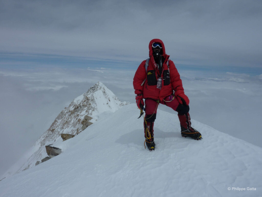
Phudorjee (O2), Philippe (O2), Ludo (without O2), Dawa (without O2), and Tendi (O2) reached the summit of Kangchenjunga at 9:10 AM. Alexey Bolotov (without O2) arrived a few minutes later. We were the first to summit Kangchenjunga that year, marking the first French ascent in 27 years. There were two layers of clouds, and only a few peaks were visible.
Later, we passed Cédric as we were climbing down the Chimney; he reached the top at 10:00 AM (without O2). We then cautiously descended the 300m of mixed terrain and reached the Couloir by 10:30 AM. Overall, the weather had improved; it was warmer, and the snow in the Couloir had transformed. We passed a Russian climber who had left very late; he reached the summit alone around 3:00 PM. Phudorjee passed us on the way down and arrived first at C4. He had been the strongest climber of the day, breaking trail for most of the route.
I reached C4 around noon, followed by Ludo and the rest of the team. We spent the remainder of the day resting and eating, but at 7,550m, it was difficult. My oxygen saturation was below 60%, and I did not feel well.
Summit Day: +1,050m / -1,050m. Time: 13h40.
Heart Rate (climb): Average: 134, Min: 106, Max: 148.
May 20: C4 - BC
We left the high camp at sunrise. It was cold, but the weather was perfect, offering outstanding views over Everest, Lhotse, Makalu, Jannu, and Yalung, stretching to the borders of Nepal and into Sikkim, India. Other teams were heading for the summit that day, taking advantage of the trail we had broken the day before.
Later, we joined the rest of the team at C2; they had endured a difficult descent the previous day in poor weather. We were all carrying heavy packs as we dismantled the camps and brought down our gear. It was a relief to be back at Base Camp after seven days spent at high altitude.
Descent: +95m / -2,140m. Time: 5h15.
May 21 - May 25: BC - France
At breakfast this morning, fatigue was visible on every face. We were exhausted and our weight loss was significant. The last two days had been arduous; we had climbed for 18 hours, skipping a night of sleep, and then descended straight from Camp 4 to Base Camp yesterday—a 2,150m descent in 5h15.
Since we were leaving Base Camp the following morning, we spent the entire day packing and preparing the loads for the porters. We planned to return via the same route as the approach, but in only four days instead of ten: Base Camp to Tseram, Tseram to Yamphudin, Yamphudin to Doban, and Doban to Tharpu.
Many years later...
It is still with deep emotion that I reread the account of this expedition. I hold an exceptional memory of those moments spent together, despite all the hardships we faced for over 50 days. Today, Ludo, Cédric, Alexey, and Phudorjee are gone, but their memory lives on.
Information
The Route
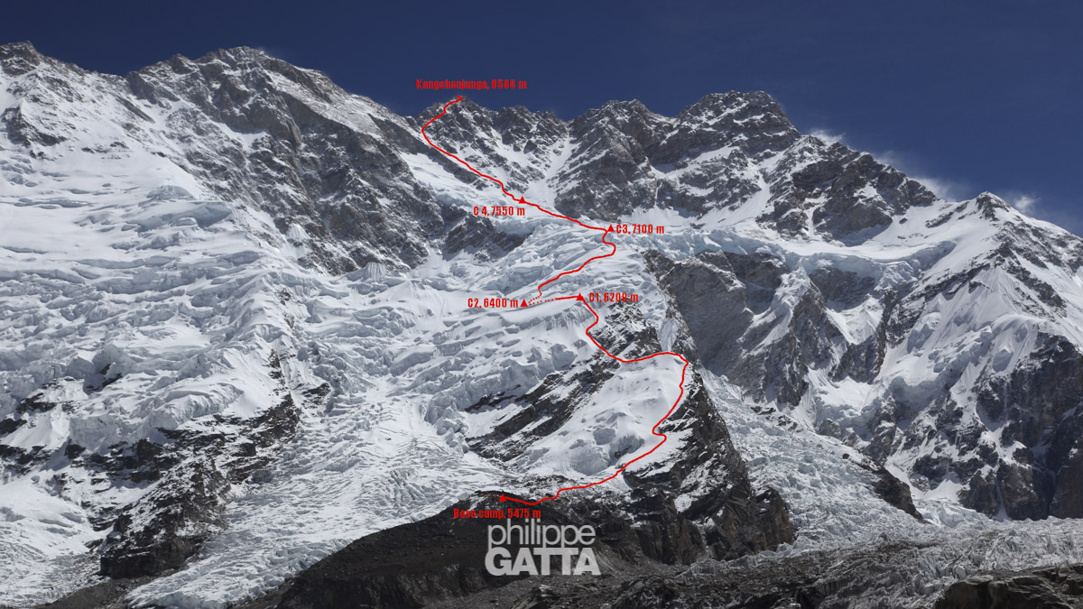
The team climbed the route first opened by Joe Brown, George Band, Norman Hardie, and Tony Streather in May 1955. This route is located on the Southwest Face of Kangchenjunga, also known as the Yalung Face. Only 162 climbers have reached the summit via this route since 1955.
The route starts at 5,500 meters on the Yalung Glacier, where the base camp is established. Above the base camp, the route follows a rocky spur up to 6,000m, then climbs steep slopes and seracs up to a snow ridge at 6,200m where Camp 1 is established.
From Camp 1, the route follows a short horizontal ridge, then descends onto and crosses a plateau. Camp 2 is located at the end of the plateau at the base of the face, at approximately 6,400m.
From Camp 2, the route climbs the snow slope above. Navigating through the numerous seracs and crevasses can be difficult, especially in poor weather. Camp 3 can be set at the top of the slope or, preferably, on the plateau itself at around 7,200m.
From Camp 3, the route continues across the plateau, through crevasses and seracs, to the base of a spur at the bottom of the Big Couloir. Camp 4 is typically established between 7,500m and 7,700m.
From Camp 4, the ascent follows the Couloir up to 8,250m. Where the Couloir splits, take the right branch and traverse right (the Diagonal) to the base of a steep wall at approximately 8,380m. Climb the wall (graded III+) and continue to a rocky tower at around 8,450m (known as the “Bivouac”). Climb a short snowy ridge, then traverse right to a chimney at approximately 8,500m. Rappel down the chimney and traverse right on mixed terrain to reach a snow slope leading to the main summit at 8,586m.