Khan Tengri (7,010m)
The Lord of the Sky
While the giants of the Himalayas and the Karakoram dominate the popular mountaineering imagination, the Tian Shan range remains one of the last great frontiers of high-altitude exploration. Nestled deep in the heart of Central Asia, stretching north and west of China’s vast Taklamakan Desert, the Tian Shan—meaning “Celestial Mountains”—form a colossal natural barrier across Kyrgyzstan, Kazakhstan, and the Xinjiang province. It is a world of extreme isolation, characterized by massive glaciers, sprawling wilderness, and peaks that rival the world’s most famous mountains in both aesthetic beauty and technical ferocity.
Within this rugged range, Khan Tengri stands as a magnificent, near-perfect pyramid of marble and ice. Reaching an elevation of 7,010 meters, it is the second-highest peak in the Tian Shan, surpassed only by its neighbor Jengish Chokusu (7,439m, historically known as Peak Pobeda or Victory Peak). The geography of this region is a complex and fascinating web of mountain systems; the Tian Shan serves as a vital tectonic link between the Pamir range to the south and the Altai Mountains of Mongolia to the northeast.
Khan Tengri itself occupies a unique and formidable position. The summit sits on the border of Kyrgyzstan and Kazakhstan, with the Chinese border lying just a few kilometers to the east, making it the geographical heart of this tri-border region. It stands sentinel to the east of the massive Lake Issyk Kul. As the tenth-largest lake in the world by volume and the second-largest saline lake, Issyk Kul acts as a vast “blue eye” amidst the vertical desert of the surrounding peaks. However, it is Khan Tengri’s latitudinal position that truly defines its character: it is the northernmost 7,000-meter peak on Earth.
This northern location has severe and direct consequences for alpinists. Being situated so far north means the climbing season is incredibly short, and the weather is notoriously unpredictable and violent. The mountain is frequently battered by cold arctic air masses, creating “Siberian” conditions that can transform a clear, sunny morning into a life-threatening storm in a matter of minutes. Even at 7,000 meters, the air feels thinner and the cold bites deeper than at similar altitudes in the Himalayas, due to the lower atmospheric pressure and the proximity to the steppe.
The mountain’s name, which translates to “Lord of the Sky” or “Prince of Spirits” in Turkic languages, reflects its mythical and sacred status in Central Asian culture. For centuries, it has served as a landmark for nomads, explorers, and pilgrims alike. To the local populations, it is also known as Kan-Too (Blood Mountain). This name comes from the unique geological composition of the peak: its marble summit glows with a deep, haunting red hue during sunset—a sight of breathtaking beauty that often belies the extreme technical challenges of its ridges and faces.
Khan Tengri Historic Timeline
First Ascent
A Soviet expedition led by Mikhail Pogrebetsky successfully completed the first ascent of the mountain. They reached the summit via the South Face and West Ridge, the route that now bears his name.
The North Face First Ascent
A team led by Boris Studenin climbed the formidable North Face for the first time. This side of the mountain is significantly colder and more technical than the southern approach.
First Winter Ascent
A Soviet team achieved the first successful winter ascent in February. Given its northern latitude, Khan Tengri in winter is considered one of the coldest and most brutal climbing environments on Earth.
The Speed Record
During a speed climbing competition, Anatoli Boukreev reached the summit from base camp (4,200m) in a staggering 6 hours and 27 minutes, a record that stood for many years as a testament to his legendary endurance.
World’s Northernmost 7,000m Peak
Following precise GPS measurements, Khan Tengri was officially confirmed as the northernmost peak on Earth exceeding 7,000 meters, reinforcing its reputation for extreme “Siberian” weather conditions.
Massive Avalanche Incident
A major tragedy occurred when a large serac collapse from Peak Chapaev triggered a massive avalanche on the Semenovsky Glacier, claiming the lives of 11 climbers and highlighting the objective dangers of the normal route.
The Snow Leopard Challenge
Khan Tengri remains a key requirement for the prestigious “Snow Leopard” award, granted to climbers who summit all five 7,000-meter peaks of the former Soviet Union.
Khan Tengri Express
Expedition Timeline
- Friday, July 27: Departure from France and flight to Bishkek, Kyrgyzstan.
- Saturday, July 28: Landed in Bishkek at 5:00 AM. Long drive to Karkara Camp (2,200m), reaching it at midnight.
- Sunday, July 29: Helicopter flight into the heart of the Tian Shan to Khan Tengri Base Camp.
- Monday, July 30: Acclimatization hike to Camp 1 (4,300m) followed by a return to BC.
- Tuesday, July 31: Load carry to Camp 1, pushing up to 4,750m before returning to BC.
- Wednesday, August 1: Rest day at Base Camp to recover before the summit push.
- Thursday, Aug 2 – Saturday, Aug 4: Progression through the high camps: C1 (4,300m), C2 (5,300m), and C3 (5,850m).
- Sunday, August 5: SUMMIT DAY. Successfully reached the top of Khan Tengri (7,010m) and descended to C3.
- Monday, August 6: Final descent from high altitude back to Base Camp.
- Tuesday, Aug 7 – Friday, Aug 10: Helicopter transfer to Karkara, drive to Bishkek, and return flight to France.
Bishkek
The expedition started in Bishkek, the capital of Kyrgyzstan. We then drove eight hours (460 km) eastward across the country, passing along the shores of the vast Issyk Kul Lake before finally reaching Karkara Camp (2,200m), where we spent our first night. From there, we flew by helicopter into the mountains to reach the Khan Tengri Base Camp.
Day 1: helicopter flight to Khan Tengri Base Camp
We left the grassy meadows of Karkara early in the morning and boarded a Mi-8 helicopter for our flight to the Khan Tengri Base Camp (BC).
In this remote corner of the Tian Shan, helicopter transport is not a luxury but the standard method of access. The vastness of the Inylchek Glacier and the total absence of roads or easy trekking trails through the rugged terrain make the flight a logistical necessity. These legendary Soviet-designed Mi-8 helicopters act as the lifelines of the range, transporting climbers, gear, and supplies into the high wilderness in a matter of minutes—a journey that would otherwise take nearly a week of grueling trekking over moving ice and moraine.
The 100 km flight was absolutely stunning, offering fantastic views over the jagged peaks and frozen rivers of the Tian Shan range. Landing on the glacier, we felt the immediate shift in environment as we stepped out into the heart of the “Celestial Mountains.”
Heart Rate: 90 bpm. Oxygen Saturation: 90%.
Day 2: Base Camp (4,050m) - Camp 1 (4,300m) - Base Camp
We left the base camp for a short acclimatization walk. We first headed to the Tian Shan Travel camp, located 30 minutes away, following an easy trail along the moraine. Since we felt strong, we decided to push on toward Camp 1, trekking across the massive South Inylchek Glacier.
There were very few crevasses, and most were relatively small; however, we encountered several ice rivers (meltwater streams) that were difficult to negotiate and cross. We reached C1 in just two hours from the BC. The camp is strategically located at the junction of the Semenovsky and Inylchek glaciers. The distance between the BC and C1 was 6.8 km, with an elevation gain of approximately 300 meters.
BC-C1-BC: 13.5 km, ±300 m. Time: 3h40.
Heart Rate: 80 bpm. Oxygen Saturation: 90%.
Day 3: Base Camp - 4,750m - Base Camp (4,050m)
We left the base camp to carry food, ropes, and gear up to Camp 1 (2h). After caching our supplies, we continued halfway toward Camp 2, reaching approximately 4,750m to scout the famous Semenovsky icefall (1h30 from C1). This reconnaissance allowed us to assess the conditions of the glacier before returning all the way to base camp.
BC – 4,750m – BC: 19 km, ±750 m. Time: 6h10.
Heart Rate: 80 bpm. Oxygen Saturation: 89%.
Day 4: Rest day at Base Camp (4,050m)
It was snowing lightly. We spent a rest day at the base camp, meticulously preparing our kit and gear for the upcoming ascent.
Heart Rate: 74 bpm. Oxygen Saturation: 92%.
Day 5: Base Camp - Camp 1 (4,300m)
As the weather forecast for the following days was promising, we left the base camp for our summit bid. We each carried a 20 kg pack containing all our kit, technical gear, and additional high-altitude food. With this significant weight, it took us 2h30 to reach Camp 1. A brief snowstorm moved in during the afternoon, but fortunately, the sky cleared up later in the evening, leaving us with a hopeful outlook for the climb ahead.
BC – C1: 6.8 km, +300 m. Time: 2h30.
Heart Rate: 82 bpm. Oxygen Saturation: 90%.
Day 6: Camp 1 - Camp 2 (5,300m)
It took us an hour and a half to get ready, and we left Camp 1 at 4:30 AM. Along the way, we retrieved the gear we had cached two days prior; combined with what we were already carrying, we ended up with a staggering 25 kg packs.
Although we were the last to leave camp, we progressively overtook most climbers before reaching the icefall. Unfortunately, seven climbers were still ahead of us when we arrived at the 20-meter serac equipped with a fixed rope. They were inexperienced, and it took them an agonizing two hours to clear the section. During this entire time, we remained dangerously exposed to potential serac falls and avalanches from Peak Chapaev. Once past the serac, it took us only 20 minutes to reach Camp 2. Our total moving time was 6 hours from C1, excluding the two hours spent waiting.
C1 – C2: 4.5 km, +1,050 m. Time: 6h (moving time).
Heart Rate: 75 bpm. Oxygen Saturation: 78%.
Day 7: Camp 2 - Camp 3 (5,850m)
Due to our limited acclimatization and the 1,000m elevation gain the previous day, we did not spend a very restful night. For once, however, we were the first team to leave Camp 2. Still hauling our 25 kg packs, we headed toward Camp 3 across gentle snow slopes.
The temperatures rose quickly as soon as the sun hit the face, and it was surprisingly warm by the time we reached Camp 3. We set up our tents on a narrow shelf directly beneath the massive serac of the West Col.
C2 – C3: 1.75 km, +550 m. Time: 2h40.
Heart Rate: 81 bpm. Oxygen Saturation: 77%.
Day 8: Camp 3 - Khan Tengri Summit (7,010m) - Camp 3
Most teams usually spend a night at Camp 3 to complete their first acclimatization rotation before returning to base camp. While this is arguably the best way to acclimatize, it also means completing two round trips of 26 km and +2,000m with massive packs—and more importantly, passing through the dangerous icefall and beneath the Chapaev slopes several more times.
We had decided beforehand to try a different strategy: climbing to Camp 3, resting there for a day or two, and then pushing straight for the summit. Unfortunately, the weather window was limited to only 24 hours, so we couldn’t afford the extra rest day as planned. However, we felt strong, and with an oxygen saturation of 77%, we decided to go for it.
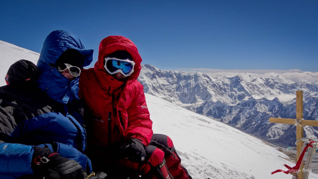
We woke up at 3:00 AM, but our progress was slow—especially melting snow for water—and we didn’t leave Camp 3 until 5:00 AM. We were the last two climbers to leave the camp. The weather was perfect: a light wind and a temperature of -25°C (windchill -31°C). We reached the summit of Khan Tengri after 10 hours of climbing.
We spent 30 minutes at the summit before beginning our descent. Due to the numerous abseils, it took us 4h40 to get back down to Camp 3.
C3 – Summit: 2.5 km, +1,200 m. Time: 10h.
Summit – C3: 2.5 km, -1,200 m. Time: 4h40.
We reached the summit of Khan Tengri after ten hours of sustained climbing. We spent thirty minutes at the top, taking in the vast, jagged horizon of the Tian Shan, before beginning our long descent.
Day 9: Camp 3 - Base Camp
The night had been short, and we were still exhausted from the 15-hour climb of the previous day. We packed all our gear, cleaned out the tent, gathered our rubbish, and began the long trek down.
Later, we made a quick stop at Camp 2 to retrieve the extra food and waste we had left there, continuing our descent with massive packs once again. We made one final stop at Camp 1 to pick up the remaining gear stored there. We finally reached Base Camp after six hours, arriving just in time for lunch. It was a relief to finally drop our loads after nearly 2,000 meters of descent.
C3 – BC: 13 km, -1,900 m. Time: 6h.
Day 10-12: return to France
Immediately after our return to base camp, the weather shifted and it began to snow heavily. Between the exhaustion from our ascent, the ridiculously small food rations remaining at base camp, the deteriorating weather, and the few days we had left, it became clear that a summit bid on Peak Pobeda was no longer feasible. We decided it was time to head home.
After waiting a couple of days for the helicopter, we made our way back to France in just a few days, thanks to excellent logistics.
Information
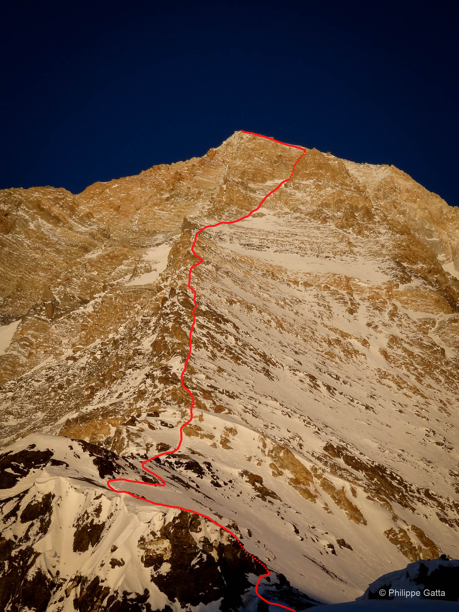
Khan Tengri: South Face and West ridge
We climbed the Pogrebetsky route on the South Face and West Ridge of Khan Tengri. The route was rated AD+ (or Russian 5a). Our base camp was located on the South Inylchek glacier at 4,050m. From there, we established three high camps at 4,300m, 5,300m, and 5,900m.
From Camp 1, the route ascended along the Semenovsky glacier. It then crossed a technical icefall starting at 4,900m, passing directly beneath the exposed slopes of Peak Chapaev. Camp 2 was situated above the icefall at approximately 5,300m in a relatively safe zone.
From Camp 2, the route continued over moderate snow slopes toward the West Col. The col sits at 5,900m, and we set Camp 3 just 50 meters below it. At the time, there were about eight tents and two snow caves established there.
Finally, above Camp 3, the terrain steepened with ice and snow sections reaching up to 60°. The route followed the ridge over sustained mixed terrain. The crux was a short rock wall rated UK 5a at 6,700m. Beyond this section, a final snow ridge led us to the summit at 7,010m.