Mont Blanc, Top of the Alps
Mont Blanc (4,808 m), the highest peak in Western Europe, is a monumental icon of the natural world. Straddling the border between France and Italy, its massive dome of ice and rock dominates the Graian Alps. Known as the “Monarch of the Alps,” its influence extends far beyond its physical borders, serving as the symbolic birthplace of modern mountaineering and a primary laboratory for glaciology and high-altitude physiology.
A Geographical Giant
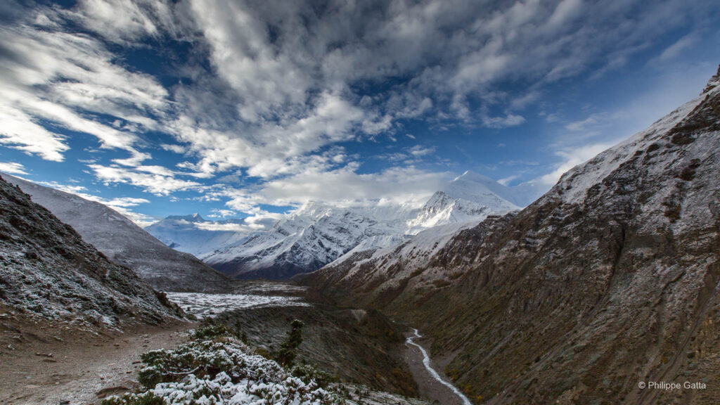
The massif is a complex labyrinth of hanging glaciers, jagged granite spires, and deep valleys. While its summit is a rounded, snow-covered dome, its flanks tell a different story. The Italian South Face (Brenva and Brouillard) is characterized by immense, vertical rock walls and chaotic icefalls, offering some of the most difficult and prestigious alpine challenges in the world. Conversely, the French northern slopes are home to the Bossons Glacier, one of the fastest-flowing glaciers in Europe, which descends steeply toward the Chamonix valley.
The Birth of Mountaineering
The history of Mont Blanc is inextricably linked to the birth of alpinism. For centuries, the peak was viewed with superstition and fear, often referred to as the “Montagne Maudite” (Cursed Mountain). This perception shifted in the mid-18th century when Horace-Bénédict de Saussure, a Genevese aristocrat and scientist, offered a reward to the first person to find a route to the summit. His motivation was purely scientific; he wished to measure the altitude and study the atmospheric conditions at the top of Europe.
On August 8, 1786, the challenge was met by two locals from Chamonix: Jacques Balmat, a crystal hunter, and Michel-Gabriel Paccard, a doctor. Their ascent, achieved with primitive equipment—alpenstocks and heavy wool clothing—is celebrated as the dawn of the golden age of mountaineering. One year later, de Saussure himself reached the summit, accompanied by a large team of guides.
Mont Blanc Historic Timeline
Following the first ascent, the 19th and 20th centuries saw a rapid evolution of routes and styles:
The First Ascent
Jacques Balmat and Dr. Michel-Gabriel Paccard reached the summit for the first time, dispelling centuries of superstition and effectively birthing modern alpinism.
First Female Ascent
Marie Paradis, a local Chamonix woman, became the first woman to reach the summit, marking the beginning of female mountaineering history.
The First “Autonomous” Woman
Henriette d’Angeville completed the first ascent organized and led by a woman. She famously refused to be carried, cementing her legacy as a true pioneer of the sport.
First Winter Ascent
James Eccles, with guides Michel and Alphonse Payot, reached the summit in January, proving that high-altitude alpinism was possible in extreme winter conditions.
Conquering the Brenva Face
Laurent Croux and his team completed the first ascent of the formidable Brenva Face, shifting the focus toward extreme technical difficulty on the Italian side.
The Integral Peuterey Ridge
Completion of the full Peuterey Ridge, one of the longest and most aesthetically demanding ridge climbs in the Alps, requiring immense endurance.
The Vincendon and Henry Tragedy
Two young climbers perished after being trapped in a storm. Their public struggle led to a national outcry and the subsequent creation of the professional rescue service, the PGHM.
Tragedy on the Freney Pillar
A violent storm struck elite teams led by Walter Bonatti and Pierre Mazeaud. Only three out of seven survived the retreat in one of the mountain’s most harrowing stories.
The Opening of Divine Providence
Patrick Gabarrou and François Marsigny opened this route on the Grand Pilier d’Angle, setting a new standard for technical difficulty on Mont Blanc.
Kilian Jornet’s Speed Record
Redefining speed in the mountains, Kilian Jornet completed the round trip from Chamonix church to the summit and back in a staggering 4 hours, 57 minutes, and 40 seconds.
Women’s Speed Record
Athlete Hillary Gerardi set a new female reference, completing the Chamonix-Summit-Chamonix circuit via the North Ridge of the Dôme du Goûter in 7 hours and 25 minutes.
Here is my selection of routes
- Goûter Route: PD – The most popular standard route, primarily a glacial ascent with some scrambling in the exposed Grand Couloir and ridge.
- Grands Mulets: PD+ – The historic first ascent path; now primarily a winter/spring ski mountaineering objective.
- Trois Monts: PD+/AD- – A scenic high-altitude traverse from the Aiguille du Midi, crossing Mont Blanc du Tacul and Mont Maudit.
- Italian Normal Route (Route des Aiguilles Grises): AD- – A long, wild, and aesthetic glacial route from the Miage Glacier, joining the Bosses Ridge for the final ascent.
- Sentinelle Rouge: AD+/D- – A historic, committed, and exposed route on the wild Brenva Face.
- Brenva Spur (Éperon de la Brenva): D – A magnificent and exposed line through the massive serac barriers of the South Face.
- Central Pillar of Freney: TD+ / 6a+ / V – A legendary route combining high-altitude rock and mixed climbing.
The Goûter Route: PD
The Goûter Route is the standard and most popular route to the summit of Mont Blanc from the French side. The Goûter route is favored for its logistical efficiency and provides the shortest summit day, starting from the highest refuge in the massif.
The ascent typically begins at the Nid d’Aigle (2,372 m), reached via the Tramway du Mont-Blanc. The first section is a steady hike to the Tête Rousse plateau. The route’s primary objective hazard is the Grand Couloir. This gully is a funnel for frequent rockfall, particularly as the day warms. Crossing it requires speed and vigilance. Once across, a long, sustained scramble (Grade II) on the broken rock of the Aiguille du Goûter leads to the Refuge du Goûter (3,835 m), perched dramatically on the edge of the cliff.
From the hut, the terrain shifts to purely glacial. The “summit push” begins at night, ascending the broad, wind-scoured slopes of the Dôme du Goûter (4,304 m). After a brief descent to the Col du Dôme and passing the Vallot emergency shelter, the climb reaches its aesthetic climax on the Arête des Bosses. This narrow, exposed snow ridge demands precise footwork and steady breathing as the altitude begins to take its toll, eventually opening up onto the summit dome.
Elevation Gain: ~2,450m total from Nid d’Aigle
Note: A strict booking system is in place. Any climber intending to stay on the mountain must have a confirmed reservation at the Tête Rousse or Goûter refuges. The route is usually climbed in two days, with an overnight stay at the Goûter or Tête Rousse.
Non-stop ascents
Non-stop ascents are becoming increasingly popular. While the most impressive records are typically set from Chamonix, I personally prefer starting from the center of Les Houches. This aesthetic line follows the Arandellys trail to the Col du Mont Lachat, where it joins the Normal Route.
For such an undertaking, it is wise to perform reconnaissance outings beforehand. A strategic approach is to cache the mandatory mountaineering equipment—such as mountain boots, ice axe, crampons, and harness—at the Tête Rousse or slightly below. This allows for a lighter and faster progression in the lower, non-glacial sections. However, it must be emphasized that a non-stop ascent of Mont Blanc remains a serious mountaineering feat, requiring high-altitude experience and proper safety gear once on the glacier.
Grands Mulets: PD+
The Grands Mulets route is the historic line taken by Balmat and Paccard during the first ascent in 1786. It traverses the heart of the northern glacial system of Mont Blanc. While it was once the standard summer route, the retreat of the glaciers and the increasing instability of the seracs have transformed it primarily into a spring ski mountaineering route.
The route typically begins at the Plan de l’Aiguille (2,317 m). Climbers must cross the “Pèlerins” and “Bossons” glaciers, navigating the Jonction—a chaotic area of ice towers and deep crevasses where the two glaciers meet. This section is highly technical and its difficulty varies significantly each season. After crossing the Jonction, a steady ascent leads to the Refuge des Grands Mulets (3,051 m), perched on a rocky island surrounded by ice.
The summit push follows the Petit Plateau and the Grand Plateau. These vast glacial basins are spectacular but present the route’s primary danger: they are overlooked by massive serac barriers. To minimize the risks, it is preferable to ascend via the North Ridge of the Dôme (Arête Nord du Dôme).
The route then joins the standard Goûter path at the Vallot shelter via the steep “Grandes Montées” or the “Corridor” (though the latter is now often too dangerous due to seracs).
Trois Monts Blancs: PD+/AD-
The Trois Monts is a grand high-altitude traverse that crosses three major peaks: Mont Blanc du Tacul, Mont Maudit, and finally Mont Blanc. Starting from the Aiguille du Midi, this route offers a spectacular, high-alpine experience and can be combined with a descent through de Gouter for a full traverse.
The journey begins with a descent from the Aiguille du Midi ridge to the Col du Midi (3,532 m). From there, the first ascent leads up the North Face of Mont Blanc du Tacul. This section is heavily glaciated and requires careful navigation around large crevasses and beneath towering seracs. After reaching the shoulder of the Tacul, the route descends slightly before tackling the steep slopes of Mont Maudit.
Then the route crosses the Col du Mont Maudit. This steep snow and ice slope (up to 50°) often features a difficult bergschrund (rimaye) that can be challenging to cross late in the season. Fixed anchors are sometimes present to facilitate the ascent. Once over the pass, a long, breathtaking traverse leads to the Col de la Brenva, providing an incredible view over the Italian side of the massif before the final push up the Mur de la Côte to the summit.
Conditions: this route is highly dependent on snow stability and the seracs & crevasses state in the Tacul. Because it involves traversing steep, north-facing slopes at very high altitudes, it is particularly susceptible to wind-slab avalanches. Most climbers stay at the Refuge des Cosmiques to allow for a very early departure (typically between 01:00 and 03:00) to ensure a safe return before the afternoon sun softens the snow bridges.
Elevation Gain: ~1,300m (but with significant undulations).
Italian Normal Route (Route des Aiguilles Grises)
The Italian Normal Route starts from the Val Veny. It offers a wild and isolated high-mountain experience, far removed from the mechanical lifts and crowds of the French side. It is a long, demanding, and varied ascent that combines a massive glacier approach with a technical rock ridge and a final high-altitude snow crest.
The journey begins with a long approach across the Miage Glacier, one of the most impressive debris-covered glaciers in the Alps. After ascending a steep moraine and a rocky headwall, climbers reach the Gonella Refuge (3,071 m), perched on a spectacular rock spur. The summit push starts with a complex navigation through the crevasses of the Dôme Glacier to reach the Pitons des Italiens on the border ridge.
From the Pitons des Italiens, the route follows the sharp and aesthetic Aiguilles Grises Ridge. This section involves mixed terrain and narrow snow crests that eventually join the Goûter route at the Dôme du Goûter. The final stage follows the classic Arête des Bosses to the summit. Due to its Southwestern orientation, the glacier section on this route is highly sensitive to heat and can become impassable early in the summer season as crevasses open.
Elevation Gain: ~3,100m from the valley; ~1,700m from the Gonella Refuge.
Sentinelle Rouge: AD+/D-
The Sentinelle Rouge is a historic and majestic line on the formidable Brenva Face. First climbed in 1927, it offers a direct passage through one of the most impressive glacial walls in the Alps. Named after a prominent red rock buttress, the route involves sustained climbing on steep snow and ice (50°-55°), exiting near the Col de la Brenva.
I did a solo speed ascent of this route at a time when it was significantly less exposed to objective hazards than it is today. It remains an exceptional memory for me, much like the other routes on this extraordinary face. However, due to climate change and increasing serac instability, the route has become a “lottery” and is now rarely climbed in summer.
The line continues to inspire high-level achievements; recently, Ross Hewitt completed a remarkable ski descent of the Sentinelle Rouge.
Brenva Spur (Éperon de la Brenva): D
The Brenva Spur is one of the most aesthetic and legendary ice, rising 1,500 meters from the Brenva Glacier to the summit of Mont Blanc. First climbed in 1865, it is a route of immense scale, offering a “Himalayan” atmosphere on the wild Italian side of the massif.
The route follows a logical and prominent ridge of snow and ice, culminating in a spectacular passage through the upper serac barrier. While the spur itself offers some protection from avalanches, the route remains a serious undertaking requiring cold temperature, good snow conditions and speed. Due to glacial recession and serac instability, it has largely shifted from a summer classic to a spring objective.
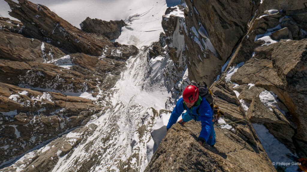
Central Pillar of Freney: TD+ / 6a+ / V
The Central Pillar of Freney is an exceptionnal route and a unique way to reach the top of Mont Blanc. Located on the wild and remote Frêney Face on the Italian side, it is a legendary route, known for its commitment, high altitude, and the technical climb “Chandelle” (the Candle) near the top. The approach is long and exposed to reach the remote Eccles Bivouac. The climb consists of sustained granite cracks and chimneys, culminating in the Chandelle—a superb pillar of exceptional red granite at 4,500 meters. The technical crux requires athletic climb, followed by a delicate exit onto the final slopes of Mont Blanc de Courmayeur.
I hold a very powerful memory of my solo ascent of the Freney. I had a few scares in several sections of soft snow on the firt half, and I was caught by a violent storm that forced a bivouac just above the Chandelle. This climb took place shortly before my departure for Cho Oyu—an expedition that proved to be equally epic.
Information
Getting There
Chamonix-Mont-Blanc is situated in the Haute-Savoie department of the French Alps, directly at the foot of the Mont Blanc massif. The valley shares borders with both Switzerland (Valais) and Italy (Aosta Valley).
By Air The closest international hub is Geneva Airport (GVA) in Switzerland, located 88 km away. Numerous shuttle services and buses provide direct transfers to Chamonix, with a travel time of approximately 1 hour and 15 minutes.
By Road From France, the town is directly accessible via the Autoroute Blanche (A40). From Italy, access is via the Mont Blanc Tunnel. From Switzerland, the route crosses the border at Martigny and passes over the Col de la Forclaz and Col des Montets.
By Train High-speed trains (TGV) connect to Saint-Gervais-le-Fayet, where the regional Mont Blanc Express train continues into the valley, serving all villages from Servoz to Vallorcine and the Swiss border.
Accommodation and Supplies
The Chamonix Valley offers a vast range of accommodation, from luxury hotels to gites and seasonal apartments. For climbers and campers, there are several well-equipped campsites, mainly located in Les Bossons, Les Praz, Les Houches, and Argentière. Advance booking is highly recommended during the peak summer (July-August) and winter seasons.
Supplies & Gear
The valley is fully equipped with several large supermarkets (Chamonix, Les Houches) and specialty food shops. Chamonix is also a global hub for technical mountaineering gear; numerous specialized shops offer equipment sales, rentals, and boot-fitting services.
Mountain Information
For the most current information on route conditions, weather, and stability, the Office de Haute Montagne (La Chamoniarde) provides a dedicated service for alpinists. It is located near the church in the town center.
Climate
The Mont Blanc massif experiences a high-alpine climate characterized by weather changes and significant temperature gradients. While Chamonix (1,035m) enjoys a temperate climate, conditions at altitude (e.g., Aiguille du Midi, 3,842m) are severe. The 0°C isotherm varies drastically, typically ranging from 3,500m to 4,500m in summer, but can drop significantly during storms.
Seasonal Breakdown
- Spring (March – May): Valley temperatures gradually rise (max +7°C to +15°C), while high altitude remains strictly frozen (-10°C to -2°C). April often brings heavy wet snow.
- Summer (June – August): Valley temperatures are pleasant (+20°C to +25°C), while summit temperatures hover around -5°C to +5°C. Afternoon thunderstorms are common.
- Autumn (Sept – Nov): Cooler, stable high-pressure windows. Valley temperatures drop back to +10°C/+15°C.
- Winter (Dec – Feb): Deep winter. Valley temperatures range from -8°C (night) to +2°C (day). High altitude is severe: -15°C to -25°C excluding windchill.
Impact of Climate Change
Rising average temperatures have led to a marked acceleration in glacial retreat and the thawing of high-altitude permafrost. This degradation of the “ice glue” that holds the granite faces together has increased the frequency of rockfalls and led to greater instability in serac zones. Consequently, many classic summer routes are now safer in spring or late autumn to avoiding the rockfall hazard of the peak summer months.
Guidebooks - Mont Blanc Massif & Aiguilles Rouges
- Aiguilles Rouges & Envers – Michel Piola:
- Aiguilles Rouges 1 & 2
- Envers des Aiguilles
- Mont-Blanc Granite Series – JMEditions (Damilano, Désécures, Laurent)
- Mont Blanc: The Finest Routes – Philippe Batoux (Éditions Guérin)
- Mont Blanc Plaisir & Classique – Marco Romelli (Idea Montagna)
- Sommets du Mont-Blanc – J.L. Laroche & F. Labaeye (Glénat)