Mont Blanc du Tacul
The Mont Blanc du Tacul (4,248 m) is one of the major summits of the Mont Blanc massif, situated between the Aiguille du Midi and the Mont Maudit. The direct access provided by the Aiguille du Midi cable car makes the summit highly popular. The mountain is characterized by its massive granite triangles on the eastern face and its glacial slopes on the northern flank, which serve as the start of the classic “Trois Monts” traverse toward the summit of Mont Blanc.
The peak’s geography offers a wide range of alpine routes. While the Normal Route via the North Face is primarily a glacial ascent, the peak is also renowned for its technical mixed climbs and excellent granite routes. Historical routes and modern lines coexist on its various pillars, couloirs and faces. The altitude and the complexity of the seracs on the northern slopes require constant attention to conditions.
For alpinists, the Mont Blanc du Tacul often serves as a point of acclimatization or a primary objective for those seeking technical faces. Its proximity to the Vallée Blanche and the Cosmiques Refuge makes it a focal point for mountaineering in the Chamonix valley.
Here is my selection of routes
- Normal Route (North Face): PD
- Bodin-Afanasieff: D / 4c / IV
- Aiguilles du Diable: D+ / 5c / IV
- Macho Route: TD- / IV / 3
- Gabarrou-Albinioni: TD- / IV / 4+
- Gervasutti Pillar: TD / 6a / IV
Normal Route (North Face): PD
The Normal Route (PD) of the Mont Blanc du Tacul follows the North Face of the mountain, starting from the Col du Midi. It is a glacial ascent that involves navigating steep snow and ice slopes, with gradients typically reaching 35° to 45°. This route is a primary component of the “Trois Monts” traverse toward the summit of Mont Blanc and is the most common path to the Tacul summit.
The technical difficulty of the ascent is highly dependent on seasonal conditions. Navigating the glacier requires constant vigilance regarding large crevasses and the state of the bergschrund, which can become difficult to cross late in the season. The route passes beneath significant serac barriers; the stability of these formations and the configuration of the snow bridges vary annually.
It also serves as the standard descent route for the other climbing lines on the mountain.
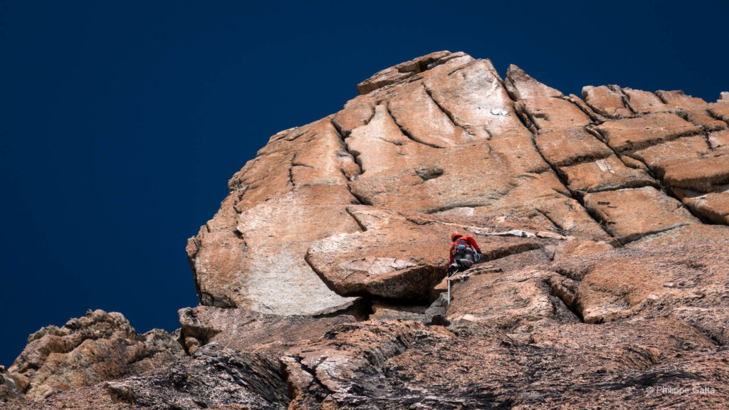
Macho Route: TD- / IV / 3
The Macho Couloir is located to the left of the Gervasutti. From the Col du Midi, head between the Gros Rognon and Pointe Lachenal. Skirt the South Face of Pointe Lachenal and head toward the base of the couloir. Ascend the couloir for 400m, which includes a few sections at 65/70°, before turning right onto the snow and ice slopes.
Alex, Frederic, and I climbed the Macho Couloir and the Bodin-Afanasieff gully during two fine days. (See photo below)
Bodin-Afanasieff: D / 4c / IV
The Afanassieff-Bodin gully is a beautiful line on the Northwest Face of the Tacul, clearly visible from Les Houches. Access is not straightforward; you must ascend along the Tacul’s Normal Route and then traverse across as best as conditions allow around 3,800m. Next, reach a small col, descend the slope behind it, and traverse left to reach the start of the gully. Climb it for 600m to the shoulder of the Tacul.
The route was first climbed in 1974 by Jean Afanassieff, Patrice Bodin.
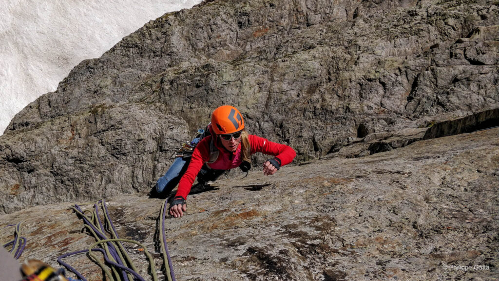
Aiguilles du Diable: D+ / 5c / IV
The Aiguilles du Diable traverse is a prominent high-altitude ridge line consisting of five distinct granite horns: Corne du Diable, Pointe Chaubert, Pointe Médiane, Pointe Carmen, and L’Isolée. This route follows the southeast ridge of the Mont Blanc du Tacul, staying consistently above 4,000 meters. The climbing is characterized by great granite pitches and rappels, concluding at the summit of the Tacul.
Historically, the peaks were climbed individually during the 1920s before the full traverse was completed. The first integral ascent of the ridge was achieved on August 4, 1928, by Miriam O’Brien, Robert L. M. Underhill, and Armand Charlet. It remains one of the most aesthetic and sought-after ridge traverses in the Mont Blanc massif due to the quality of the rock and the continuous high-alpine environment.
I climbed the Aiguilles du Diable with Morgan Baduel, who took the great photo at the top of this page.
Gabarrou-Albinioni: TD- / IV / 4+
The Gabarrou-Albinioni is one of the most famous ice gullies (goulottes) in the Mont Blanc massif, located on the East Face of the Mont Blanc du Tacul. This aesthetic line follows a deep, narrow couloir of ice that carves through the red granite pillar. The route is renowned for its consistent steep ice, with several technical pitches reaching 85°, depending on conditions and ice accumulation. Approximately 500 meters of climbing lead to the easier upper slopes.
The route was first climbed on July 5, 1974, by Patrick Gabarrou and Jean-Pierre Albinioni. This ascent marked a significant moment in the development of modern ice climbing in the Alps, showcasing the potential for technical gully lines on the major faces of the massif. Today, it remains a reference for alpinists seeking high-quality alpine ice in a spectacular and committed setting.
Another fine day spent in the mountains with Pascal.
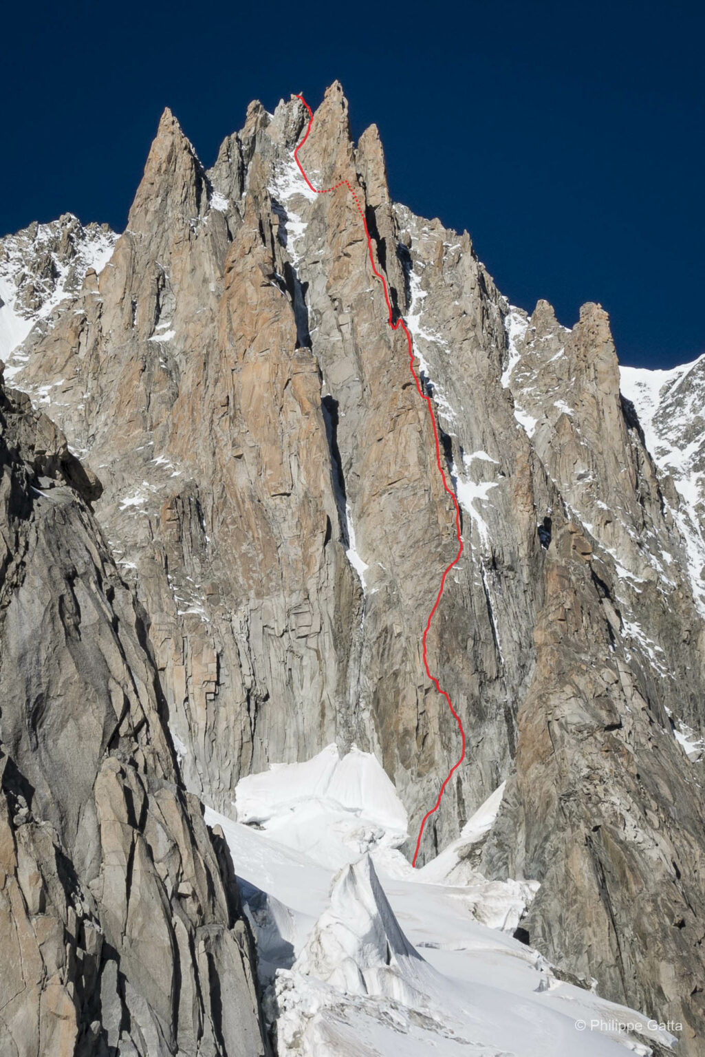
Gervasutti Pillar: TD / 6a / IV
The Gervasutti Pillar is a major route on the East Face of Mont Blanc du Tacul (4,248 m). First ascended in 1951 by Piero Fornelli and Giovanni Mauro, this 800-meter line (TD / 6a) is considered a high-altitude classic, offering a wide variety of climbing styles on exceptional red granite.
Morgan and I took the first lift to the Aiguille du Midi and started climbing just before 09:00. Fortunately, the relatively cold temperatures limited the rockfall in the first exposed pitches. The climb on the first half of the pillar was amazing, featuring high-quality red granite. The first pitch was tricky, being both technical and sustained.
On the higher part of the pillar, the route traverses right into the North Face. Unfortunately, we joined the North Face too early, misled by old slings and anchors. We climbed for about three pitches in very loose rock until we finally realized our mistake. We lost time and energy there. A rock hit one of our ropes, which we had to cut, but fortunately, we lost only a few meters. We abseiled down to get back to where we had been three hours earlier.
We continued climbing without further mistakes, but 900 meters is quite long, and we reached the summit of Mont Blanc du Tacul in the dark. We eventually reached the Cosmiques Refuge around midnight, quite tired but happy.
Information
Getting There
Chamonix-Mont-Blanc is centrally located in the Northern French Alps, near the borders of Switzerland and Italy. Its accessibility is a primary factor in its status as a major mountaineering hub, with established transport links for both international and regional travelers.
By Air: The primary international gateway is Geneva Airport (GVA) in Switzerland, located approximately 88 kilometers from Chamonix. Numerous airlines operate year-round flights from major European and international cities. From the airport, several professional shuttle services provide direct transfers to the Chamonix Valley, with a travel time of roughly 1 hour and 15 minutes.
By Road: Chamonix is directly accessible via the Autoroute Blanche (A40), which connects to the broader European motorway network. From Italy, the town is reached via the Mont Blanc Tunnel, which links the Aosta Valley directly to Chamonix. For those traveling from Switzerland, the route typically involves the Martigny – Col de la Forclaz – Col des Montets pass. Within the valley, a comprehensive bus and train network (the Mont Blanc Express) allows for movement between the various lift stations without the need for a private vehicle.
Accommodation and Supplies
Chamonix offers a vast range of accommodation and supply options, serving as the logistical center for mountaineering in the Mont Blanc massif. Due to its popularity, advance booking is recommended, particularly during the peak summer and winter seasons.
Accommodation Options: the town offers numerous hotels, seasonal apartments, and several well-equipped campsites, such as those in the Les Praz, Les Houches or Les Bossons areas.
Supplies and Services: the valley is equipped with several large supermarkets and local specialty food shops for expedition provisions. Chamonix is also a global hub for technical gear; numerous specialized shops offer equipment sales, rentals, and repair services. For the most recent information on mountain conditions and route stability, the Office de Haute Montagne (La Chamoniarde) provides a dedicated information service for climbers and guides.
Climate and Environmental Impact
Chamonix-Mont-Blanc experiences a temperate mountain climate, though the valley’s deep topography creates significant local variations. In the town (1,035 m), summer temperatures are generally pleasant, often ranging between 15°C and 25°C, while winters are cold with frequent snowfall and temperatures regularly dropping below 0°C. However, the valley increasingly experiences heatwaves during the summer months, reflecting a broader shift in alpine weather patterns.
The impact of climate change is particularly visible in the Mont Blanc massif. Rising average temperatures have led to a marked acceleration in glacial retreat and the thawing of high-altitude permafrost. This degradation of the “ice glue” that holds the granite faces together has increased the frequency of rockfalls on technical routes and led to greater instability in serac zones. Consequently, traditional climbing routes are becoming more hazardous during the peak summer months of July and August.
These environmental shifts are causing a significant shift in mountaineering seasons. Many classic routes, once considered summer objectives, are now increasingly climbed during the spring or late autumn to benefit from more stable conditions and better snow cover. This “seasonal shift” requires alpinists to be more flexible and to prioritize early-season windows when the high-altitude terrain remains frozen and secure.
Guidebooks - Mont Blanc Massif & Aiguilles Rouges
- Aiguilles Rouges & Envers – Michel Piola:
- Aiguilles Rouges 1 & 2
- Envers des Aiguilles
- Mont-Blanc Granite Series – JMEditions (Damilano, Désécures, Laurent)
- Mont Blanc: The Finest Routes – Philippe Batoux (Éditions Guérin)
- Mont Blanc Plaisir & Classique – Marco Romelli (Idea Montagna)
- Sommets du Mont-Blanc – J.L. Laroche & F. Labaeye (Glénat)