Introduction
The Spine Challenger is a 174km winter ultra-marathon that serves as the shorter counterpart to the established Spine Race. While the full Spine Race covers 430km of the Pennine Way to the Scottish border, the Challenger offers a shorter version of this great endurance race.
The Route and Terrain: The race begins in the village of Edale in the Peak District and pushes northward to finish in Hawes, located in the Yorkshire Dales. While the distance is shorter than the full race, the difficulty is significant. The route covers 5,400m of elevation gain, crossing a mix of technical trails. Runners navigate flagstone slabs, mud, rocky fells, and peat bogs. The course is also punctuated by numerous gates, stiles, and bridges that break the rhythm and require constant effort.
Winter Conditions and Darkness: Racing in Northern England in January means facing the conditions of the British winter. Competitors are exposed to sub-zero temperatures, gale-force winds, snow, and ice. The wind chill and the feeling of isolation on the high moors often comparable to the cold conditions found on remote treks like the Kungsleden. Beyond the cold, the darkness is a major factor; with only about eight hours of daylight, runners spend up to sixteen hours navigating by headlamp. In these conditions, trail markers can be obscured by snow or fog, making proficiency with a map, compass, and GPS essential for safety.
A Test of Self-Sufficiency: Unlike the maintained trails and frequent aid stations found in other trail running races, the Spine Challenger offers minimal support. There is only one major checkpoint at Hebden Bridge where runners can rest. Between the start and this point, athletes must be self-sufficient. The mandatory kit list reflects this requirement: every runner carries a sleeping bag, a bivy or tent, a cooking stove, and enough food for at least two days.
The spirit of the race is unique. While the volunteers and medical teams are dedicated, the event demands a high level of autonomy. There are few course markings and less support than common in other races, focusing the experience on the runner and the environment.
The Spine Challenger report
The Start from Edale
We began the race on Saturday morning at 8:00 am as scheduled. The weather was relatively stable for a January morning in the Peak District, with cloudy skies and a temperature of -2°C, and crucially, no rain.
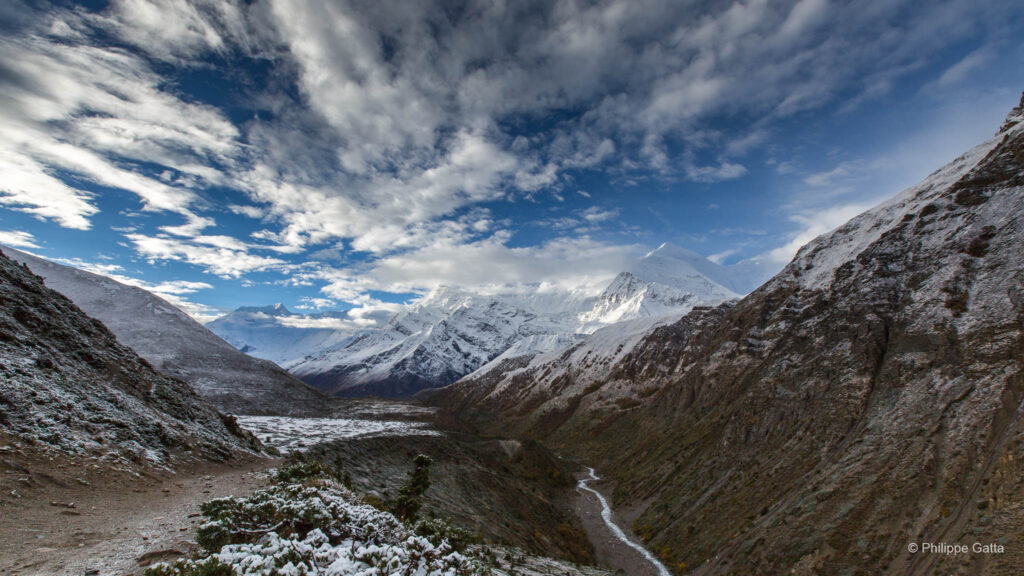
As we climbed out of the Edale valley and approached the ridge of Kinder Low, the conditions shifted rapidly. The wind intensified, with gusts reaching 70km/h across the plateau. Despite this, the area offered striking views over the Dark Peak, with white frost covering the peat and dark clouds in the sky.
After passing Mill Hill, I encountered the paved path. Running on these flagstone slabs, covered in a thin layer of verglas, was challenging and caused me to fall several times. It was a difficult necessity; running through the surrounding moss and deep swampy terrain that defines this part of the Pennines would have been even more demanding. We stopped at Snake Road (the A57 crossing) for a brief race control check before continuing on to Bleaklow Head, a vast moorland known for its navigation difficulties in fog.
Fortunately, the freezing temperatures solidified the ground. The notorious mud was frozen hard, so I did not have to battle through the deep bog and water that usually characterizes this section. Despite this, the terrain remained rough and uneven, reminding me of the frozen salt flats of the Atacama Desert.
Across the Moors to Torside
Although I made some navigation mistakes after Bleaklow Head, traversing the peat groughs was manageable, and the trail descending to Torside Reservoir was mostly good. I met Mike around the reservoir, and we ran together for a few kilometers.
However, the physical toll began to set in early. I started feeling fatigued after Crowden and struggled along the exposed ridge of Laddow Rocks. The trail clings to the edge of the gritstone escarpment; the wind was intense, making it difficult to maintain a steady rhythm. It was mentally challenging to feel this tired after only 30km, knowing there were still 140km remaining.
I focused on my nutrition, which helped regain some energy. Although the wind remained strong, the sky cleared, revealing the character of the moorlands. The section around Wessenden Reservoir, Black Moss Reservoir, and Millstone Edge offered flatter tracks, which felt more manageable. Meeting Euan and Mike again provided a welcome boost.
Nightfall and Stoodley Pike
I joined Gary and Steve near the M62 motorway crossing, a contrast to the isolated terrain. Darkness fell as we passed Warland Reservoir. I left them just before reaching Stoodley Pike, the 120-foot monument that serves as a landmark in the dark. I hesitated while crossing the fields below the monument, as the path was indistinct, but eventually found the trail leading down into the valley toward Hebden Bridge.
Reaching Checkpoint 1 was a final hurdle; there was a steep 200m climb out of the valley, and navigation was complex in the network of paths. I met Euan, and we reached the checkpoint together at 7:39 pm. We were only ten minutes behind my schedule, which was satisfactory given the conditions.
Checkpoint 1 Hebden Bridge
Overall, I was not overly fatigued, and my feet were in relatively good shape. I spent 1 hour and 15 minutes at the checkpoint, focusing on refueling. I consumed a significant amount of Chili Con Carne and muffins, seeking calories. In my haste, I drank half a bottle of orange juice that was undiluted syrup—a mistake, but it provided a necessary sugar spike.
Before leaving, I changed the strapping on my feet and put on dry socks, preparing myself for the remaining 100km through the night.
The Long Night to Cowling
Upon leaving the warmth of the checkpoint, I made some navigation errors in the dark lanes but quickly returned to the track. The respite for my feet was brief; we had to cross a swampy area known as Heptonstall Moor. Despite my efforts to avoid the bogs, I fell into freezing water several times. It was frustrating, as I knew my feet would remain wet for the rest of the race, increasing the risk of blisters.
On the climb after Walshaw Reservoir, the terrain was a combination of ice, mud, and water, making running difficult. I have little memory of this section; it became a blur of focus and fatigue.
Later, we met Euan at Cowling, a small village that felt deserted at that hour. He provided us with necessary food and drink. We left Cowling around 1:30 am and soon joined Andy.
Fighting the Cold
As the night deepened, temperatures dropped further. I realized to my concern that I had left one of my thermal layers in my drop bag at the checkpoint. Due to the technical terrain, we could not run fast enough to generate sufficient body heat, and I began to feel the cold.
Our progress was slow. I continued eating and drinking to maintain my metabolism and avoid hypoglycemia and hypothermia. Progressing through fifteen hours of darkness is demanding. It is a mental battle against the pace, the cold, the lack of sleep, and the cumulative fatigue from sixteen hours of racing. We moved in a state of exhaustion, waiting for the sun.
After sunrise, we arrived at Malham, a notable village in the Yorkshire Dales, almost three hours behind schedule. Julie provided us with water and food before we left for the limestone pavement of Malham Cove.
Malham Cove and Pen-y-ghent
Eugeni and I made a navigation error right after the cove, heading west instead of east. This mistake added another 500m to our journey, but being behind schedule allowed us to see the scenery in the daylight. The amphitheater-shaped cliff of Malham Cove was a contrast to the darkness of the night.
Although the temperatures rose slightly and the wind subsided, the clouds soon returned. The race team gave us water before we reached Malham Tarn, the highest lime-rich lake in England. This area is relatively flat, and we were finally able to run for a duration.
Julie and Euan resupplied us again at Silverdale Road, and we headed toward Pen-y-ghent, one of the Yorkshire Three Peaks. They mentioned that the front runners were not far ahead and moving slowly. For the first time, we considered that a lead position was a possibility.
The Final Push to Hawes
It was snowing when we reached the summit of Pen-y-ghent, and the snow persisted until the end, creating whiteout conditions. Eugeni maintained a competitive pace, knowing we were closing the gap. We left the other runners behind and increased our speed, even on the uphill sections.
However, twenty-eight hours of continuous racing affected our focus. We both forgot a detail from the briefing: we were permitted to skip the detour into Horton-in-Ribblesdale. Instead, we followed the traditional Pennine Way trail, adding an extra 4.2km to our journey.
Despite this, we passed one runner. I maintained my pace while Eugeni slowed slightly, as he still had 256km remaining for the full version of the race. His performance was consistent and his presence was helpful.
I took the lead just 4km from the finish. I ran the final descent into Hawes as fast as possible. I lost some time navigating the final streets but completed the race in first place after 32 hours and 18 minutes, improving the previous course record by four hours.
Many thanks to Mike, Euan, and Julie for their support throughout the race. Mark arrived sixteen minutes later, followed by Eugeni, who eventually won the full version of the race in five days, four hours, and fifty-two minutes—setting a new record as well. It was a demanding end to a challenging weekend.
Information & Logistics
Landscapes and Highlights
The Spine Challenger route traverses three distinct geological areas of Northern England.
- The Peak District: The journey begins here, characterized by gritstone plateaus such as Kinder Scout and Bleaklow. These are vast, peat-covered moorlands that remain remote, despite being situated between the cities of Manchester and Sheffield.
- The South Pennines: Moving north, the trail enters a historic industrial landscape. The moors here are crossed by old packhorse routes and canals. The town of Hebden Bridge, formerly a mill town, sits deep in the valley with its distinctive stone architecture.
- The Yorkshire Dales: The final section toward Hawes shifts geologically to limestone. The landscape becomes greener, featuring Malham Cove, a natural limestone amphitheater formed by glacial meltwater, and Pen-y-ghent, one of the Three Peaks. The finish line, Hawes, is a market town in the Dales, known for its Wensleydale cheese.
A Trail with History
The Pennine Way is the first National Trail in the UK, opened in 1965. The concept was proposed in 1935, inspired by the Appalachian Trail in the USA. The route passes near Kinder Scout, the site of the 1932 Mass Trespass where walkers fought for access to open country. This event led to the establishment of National Parks in Britain. Walking this trail pays tribute to the hikers who secured public access to these moors.
Climate and When to Go
The Pennine Way is known as a wet trail in England. The peat bogs act as sponges, and the path is exposed to prevailing Atlantic weather systems.
- Trail Running and Hiking (May – September): The best period to visit is late spring or early autumn. May and June often offer the driest ground conditions and long daylight hours. Late August and September bring the purple bloom of the heather across the moors.
- Winter Conditions: Attempting the route in winter is an expedition rather than a hike. The days are short, and the combination of freezing rain, snow, and winds on exposed ridges like Laddow Rocks makes it demanding for those without experience.
- The Peat Bogs: Regardless of the season, wet ground is common. The trail is known for its deep peat bogs, particularly around Bleaklow. While many sections have been paved with flagstones to protect the terrain, waterproof equipment is standard for local runners.
Access and Logistics
Unlike circular routes, the linear nature of the Pennine Way requires planning.
- Getting to the Start (Edale): Edale is accessible by train from Manchester or Sheffield, providing an accessible start to the trail.
- Returning from Hawes: The finish of the race is remote. Hawes does not have a train station. You must take a bus to Garsdale Head or Northallerton to connect to the rail network.
- Accommodation: For those not racing non-stop, the route is well-serviced. Options range from campsites and hostels to guesthouses in villages such as Crowden, Hebden Bridge, and Malham.