A Trans-Alpine Odyssey
The Via Alpina Network
The Via Alpina is a network of hiking trails designed to connect the Alpine arc. Established in the early 2000s with the support of the Alpine Convention, the project fosters sustainable development and cross-border discovery. It links eight countries: Italy, Slovenia, Austria, Germany, Liechtenstein, Switzerland, France, and Monaco.
The network spans over 5,000 kilometers and is traditionally divided into five color-coded trails (Red, Green, Yellow, Blue, and Purple), comprising more than 340 stages. This structure offers flexibility; hikers can attempt a thru-hike of a specific route or combine sections for shorter regional traverses. The Via Alpina connects cultures and languages across the largest recreational infrastructure in Europe.
The Five Routes
The Red Trail is the central backbone of the network. It follows a route starting from Trieste, Italy, on the Adriatic coast, and ending in Monaco on the Mediterranean. It crosses all eight countries, requiring approximately 161 stages. It is a common choice for a Trans-Alpine experience, passing through major massifs like the Julian Alps, the Dolomites, the Silvretta, and the Vanoise.
The other routes offer regional focuses:
- The Green Trail: A shorter route focusing on the Swiss Alps and the Bernese Oberland.
- The Yellow Trail: Connects the Adriatic to the Allgäu, crossing the Dolomites and the Austrian Ötztal Alps.
- The Blue Trail: Focuses on the southern and western frontiers, linking the Swiss, Italian, and French Alps.
- The Purple Trail: Explores the eastern limestone ranges across Slovenia, Austria, and Germany.
A Cultural and Geographic Journey
What sets the Via Alpina apart from other long-distance trails like the GR5 or the Tour du Mont Blanc is its cultural diversity. Because the route stays primarily at mid-altitudes (generally between 1,000m and 3,000m), it passes through inhabited valleys and villages. This allows hikers to witness changes in architecture and language—from Slavic influences in the east to the traditions of Tyrol, and the atmosphere of the Southern Alps.
The terrain varies from the karst plateaus of Slovenia to the glaciated peaks of the Central Alps and the coastal trails of the Mediterranean. It presents a logistical challenge, requiring navigation through different national park regulations and trail systems. While the Red Trail is the most prominent, the historic network remains fully accessible for those wanting to create their own trans-European journey.
From Triglav to Chamonix
The Objective
After completing the Great Himalayan Trail (GHT) in Nepal, we sought a European equivalent—a challenge that would allow us to find that specific long-distance rhythm again. Our goal was to traverse seven countries in under 30 days, covering approximately 1,000km. We aimed to link some of the most notable national parks in the Alps into a single, continuous journey.
A Hybrid Route
We decided not to stick rigidly to one specific itinerary. Instead, we designed a hybrid route to focus on the high mountains.
- The Start: We began in Slovenia, inside the Triglav National Park.
- The Middle: We followed the Via Alpina Red Trail across the Dolomites (Italy), Tyrol (Austria), Bavaria (Germany), and into Liechtenstein.
- The Switch: Upon reaching the Rhine Valley, we switched to the Via Alpina Green Trail, which took us across Switzerland as far as Lenk.
- The Finish: From Lenk, we navigated our own route to reach the final destination: Chamonix, France.
Logistics and Style
We traveled light, adopting a fastpacking approach. Our packs contained only the essentials to remain autonomous for five to six days at a time: light clothing, a sleeping bag, an ultralight tent, and a stove. We mixed wild camping with nights near mountain huts, resupplying food in villages and relying on a few parcels we had shipped ahead to strategic locations.
Managing the urban transitions
A key part of our strategy was to prioritize the quality of the running experience over a continuous, unbroken line. The Alps are densely populated, and the valleys often involve long stretches of tarmac or industrial zones. To keep the experience focused on nature, we made the conscious decision to use local transport to skip these urbanized valley floors. We ran the trails and the passes, but avoided running along highways. The distances and elevation gains recorded here reflect only what we actually covered on foot.
Key Stats
- Total Distance (Running): ~1,000km
- Duration: 28 Days
- Start: Triglav National Park (Slovenia)
- Finish: Chamonix (France)
Our Journey
The Eastern Limestone and the Carnic Ridge
Day 1-5 | Triglav (Slovenia) – Filmoorhütte (Austria). Stats: Approx. 190km / +11,400m
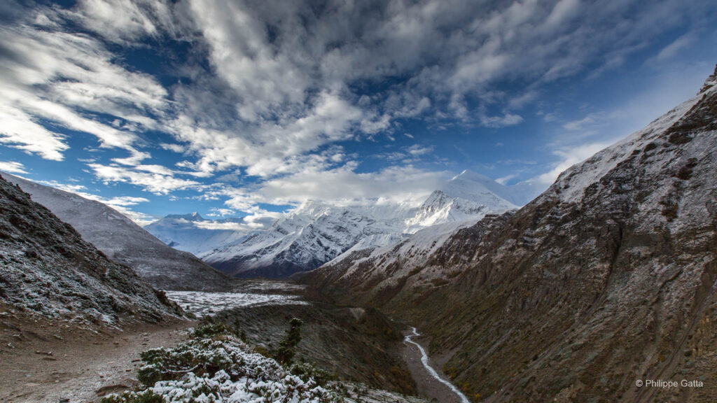
Our traverse began at the Koca na Gozdu mountain hut, below the Vršič Pass in the heart of the Triglav National Park. The Julian Alps of Slovenia provided an introduction to the range; the limestone is pale and jagged, rising out of lush valleys. Looking at the peaks of Triglav, we realized we could have spent more time exploring this park. For future hikers, starting further south to traverse the entirety of this massif would be an interesting extension.
Leaving the park, we headed toward Rateče and the border point where Slovenia, Austria, and Italy converge. The transition was physically demanding. The descent and subsequent crossing of Thörl-Maglern involved less interesting terrain until we reached the Goriacher Alm. We pitched our tent for the first time that night in the forest. We were glad not to encounter any of the bears reported to inhabit these borderlands.
From here, the character of the trail shifted as we climbed toward the Carnic Alps. The route passed through high mountain pastures and spruce forests before reaching the ski resort of Nassfeld. We continued to sleep at the Lomasti bivouac, which provided a simple but effective shelter.
For the next three days, the trail followed the border ridge between Austria and Italy. This section is a highlight of the Eastern Alps. Walking consistently above the tree line, we had panoramic views of the eastern ranges and the Dolomites ahead. The trail is technical and narrow, often following the edge of the crest. Progress was slower than in the valleys, and water management became difficult as springs are rare on the ridge and the rock is exposed.
The Dolomite Contrast
Day 6-8 | Filmoorhütte (Austria) – Lago di Neves (Italy). Stats: Approx. 110km / +5,700m
Leaving Filmoorhütte, the technical terrain continued. We realized too late that skipping the Sillianer Hütte would have allowed us to take a more rolling trail through meadows directly to Moos. Arriving in Moos, a few kilometers south of Sexten, was a milestone as it marked the end of our time on the solitary border ridge.
Crossing into the Dolomites (South Tyrol) was a significant change. We moved from the quiet ridges of the Carnic Alps into hot conditions and increased tourism. The visual reward was undeniable. The climb to Refugio Locatelli offered an iconic view of the Tre Cime di Lavaredo. The verticality of these towers is notable, even when the area is crowded.
We descended the western side on a rocky trail toward Höhlensteintal. Seeking solitude, we bivouacked in the forest that night before traversing the nature park the following day—one of the most scenic sections of the entire Via Alpina.
However, not every section was scenic. The connection between Lago di Braies and Anterselva di Mezzo involved tarmac with little interest for a runner, so we moved quickly. We found respite at a campsite in Antholz before a 1,530-meter non-stop ascent to the Rieserfernerhütte. The effort was demanding, but the subsequent descent to Sand in Taufers was efficient.
The weather deteriorated after Sand in Taufers. A violent storm forced us to abandon the exposed high route of the Via Alpina. We opted for safety, following the lower valley road through Mühlwald. We eventually reached Lago di Neves. There were no huts open by the lake, but a local farmer allowed us to sleep in his barn. Staying in the hay, out of the rain, was a welcome relief.
Tyrolean Gems and Limestone Walls
Day 9-14 | Lago di Neves (Italy) – Biberwier (Austria). Stats: Approx. 200km / +9,000m
We set off toward Pfitscherjoch Haus under a overcast sky that soon brought heavy rain. Crossing the Gliderscharte Pass (2,644m), visibility dropped to less than 50 meters. We relied on GPS navigation, moving between waypoints in the fog. We arrived at the Passo di Vizze hut cold and soaked. Fortunately, the weather improved the next day, revealing the Zillertal valley as we descended toward Mayrhofen, returning to Austria.
After a necessary rest in Schwaz, we entered the Karwendel, a nature park north of Innsbruck. This was a standout region. The Karwendel is serene, featuring a landscape of contrasts where meadows meet vertical limestone walls.
Wild camping is prohibited here, so we stayed at the Falkenhütte. We continued through the rest of the range during a heavy thunderstorm, eventually stopping in Scharnitz before camping at Reindlau.
The next morning, we left Reindlau early. The damp trail was covered with black and yellow salamanders, sluggish in the morning cool. We navigated around them as we began a 1,420-meter ascent into the Wetterstein Mountains. We passed the Meilerhütte—well-situated on the saddle marking the German border—and descended into the Reintal Valley.
This descent, dropping 1,500 meters over 5km, was demanding, but the scenery was remarkable. The Reintal Valley is a notable geological region south of Garmisch-Partenkirchen. As we moved west, the valley floor rose, dominated by the Zugspitze, Germany’s highest peak. It is a popular area, and the rock amphitheater is extensive. Skirting the summit, the trail turned south to the Gatterl Pass, taking us back into Austria and down to Biberwier.
Crossing the Rhine
Day 15-18 | Biberwier (Austria) – Gaflei (Liechtenstein) – Untersass (Switzerland). Stats: Approx. 140km / +6,500m
Logistics require pragmatism. The section after Biberwier was less isolated, so we took a bus to Weißenbach am Lech. Even after resuming the trail, the next 18km were largely dirt tracks and roads—sections we would reconsider skipping in the future. The rain returned as we traveled toward the Prinz Luitpoldhaus.
The conditions improved the next day. The descent toward Oberstdorf was atmospheric, with numerous waterfalls swollen by the rain. However, the valley floor involved a paved section, so we used a bus to Birgsau to bypass the road. From Birgsau to Hochtannberg, the Via Alpina was scenic, winding through high pastures to Buchboden.
We faced another logistical decision between Buchboden and Feldkirch: 35km of road running. We chose to use local transport, preserving our energy for the mountains. This brought us to the state of Liechtenstein.
The climb from Feldkirch to Gafleispitz is a continuous 1,900-meter ascent over 13km. The terrain below the Alpspitz is technical, exposed, and hazardous during a storm; it required total concentration.
At Gaflei, we reached a turning point: we left the Red Trail and transitioned to the Green Trail. This section into Switzerland involved navigating the Rhine Valley—an area of urban development, trains, and highways. We used the local bus network to bypass the urban areas, eventually finding a bivouac spot near Untersass to begin the Swiss chapter.
The Green Trail and the Alpine Finale
Day 19-25 | Untersass (Switzerland) – Chamonix (France). Stats: Approx. 280km / +12,700m
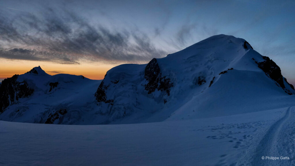
Switzerland provided a landscape of meadows and perfectly marked trails. We left Untersass and crossed the Klausenpass, where the valley of Urnerboden was impressive—a flat meadow floor enclosed by limestone cliffs and dominated by the glaciated peak of the Clariden (3,267m).
However, the Swiss Via Alpina included many paved sections. The descent to Altdorf involved over 20km of hard ground. We continued, finding respite near the Surenenpass before descending into Engelberg. The climb out of Engelberg followed a ski lift, but once we cleared the infrastructure at Jochpass, the views became striking. We ran past the Tannensee lake and down into Meiringen.
The region of Meiringen, Grindelwald, and Lauterbrunnen is a central part of the Bernese Oberland. The views of the Eiger, Mönch, and Jungfrau are imposing—massive walls of rock and ice that overlook the valleys. We moved quickly through the tourist hubs, finding relief in the car-free village of Mürren and the run toward Adelboden. This section is characteristic of the Alps: snowy peaks framing timber-chalet villages.
At Adelboden, we resupplied for the final push to Lenk. The climb to Hahnenmoospass was marked by ski infrastructure. We arrived in Lenk in the rain, marking the official end of the Via Alpina Green Trail.
From there, we followed our own route toward Chamonix. Snow began to fall above 2,000m, and temperatures dropped. We made the decision to reroute south, crossing the Rawilpass to join the Sion–Martigny axis. We navigated the pass in a whiteout storm, relying on GPS, and arrived in Sion soaked and cold.
The final days involved fatigue and poor weather. After twenty-five days of movement, we crossed the border into France and arrived in Chamonix. We were exhausted but satisfied. Crossing the Alpine arc is a rhythm of highs and lows. It was a rigorous and memorable adventure. If we were to do it again, we would skip the valley floors, but we wouldn’t trade the experience of the high passes.
Information & Logistic
Access: Gateways to the Trail
The Alps have an extensive public transport network, making it easy to section-hike this route. You do not need to do it all at once.
- East (Start): Ljubljana is the main hub for Slovenia, with bus and train connections to Jesenice and the Triglav National Park. Villach (Austria) is also a key rail hub near the border.
- Central: Innsbruck is a central access point. It has an airport and trains connecting directly to the Karwendel and Zillertal valleys. Bolzano and Brixen are the main rail hubs for the Dolomites.
- West (Finish): Zurich and Bern provide rail access to the Swiss sections (Linthal, Meiringen, Lenk). Geneva is the standard gateway for Chamonix.
Major Protected Areas
This itinerary threads together some of Europe’s notable environmental reserves. Understanding these areas is important, particularly regarding regulations.
- Triglav National Park (Slovenia): The only national park in Slovenia. A rugged karst landscape where nature conservation is enforced.
- The Dolomites (Italy): The route crosses several nature parks, including the Tre Cime and Fanes-Senes-Braies parks. These are UNESCO World Heritage sites known for their geology.
- Zillertal Alps and Karwendel Nature Park (Austria): Large protected areas in Tyrol. The Karwendel is the largest nature park in Austria, known for its biodiversity and limestone walls.
- Jungfrau-Aletsch (Switzerland): While the Via Alpina skirts the edge, the views in the Bernese Oberland overlook the UNESCO protected area of the Aletsch Glacier.
Climate and Seasonality
- Best Window: Mid-July to mid-September.
- June: Many high passes (above 2,300m) may still hold significant snow. Huts may not be open yet.
- October: Favorable colors, but days are short, huts are closed, and early snowstorms are possible.
- Weather: The Alps are subject to late afternoon thunderstorms. For runners, this means starting at dawn to clear high exposed ridges before 2:00 PM.
Accommodation: Huts and Refuges
The density of accommodation in the Alps is high.
- Frequency: On the Red and Green Trails, you typically encounter a mountain hut (Hütte / Rifugio / Cabane) every three to five hours of hiking. For a trail runner, this provides multiple resupply points per day.
- Booking: Popular huts (especially in the Dolomites, the Mont Blanc area, and Triglav) often require booking in advance. However, smaller private huts or valley Gasthöfe (guesthouses) may have last-minute space.
- Facilities: Most huts offer meals, showers, and dormitory-style sleeping. This allows travelers to carry lighter packs by skipping camping gear.
Bivouac and Wild Camping
Regulations vary significantly by region:
- Slovenia: Wild camping is prohibited in Triglav National Park.
- Austria (Tyrol): Laws are strict. Camping is generally forbidden in forests and above the treeline, especially in nature parks like the Karwendel. Emergency bivouac is the only exception.
- Italy: Generally tolerated above 2,500m (from sunset to sunrise), but prohibited in national and regional parks.
- Switzerland: Generally the most tolerant. Camping above the tree line is usually accepted for one night, provided it is not in a restricted area or nature reserve.
- Our strategy: Because we wanted to camp, we often descended to official campsites in the valleys or asked residents for permission to pitch near their properties. Wild camping requires careful study of local regulations.
Specific Tips for Runners
- Water Availability: In Switzerland and Austria, troughs and fountains are common. In limestone regions like Slovenia, the Dolomites, and the Karwendel, surface water is rare due to the porous rock. Carrying a larger capacity (1.5L+) is recommended.
- Terrain and Shoes: The terrain is often rocky and technical. Cushioned trail shoes with aggressive lugs are essential. Limestone is slippery when wet.
- Navigation: While the trails are marked, systems change across borders. A GPS with the track is recommended to maintain flow, as signs can be sparse on high plateaus.
Food and Resupply: What to Expect
Unlike remote trails in Canada or Lapland, the Via Alpina is never far from settlements, though timing is important.
- Village Shops: Most valleys have supermarkets, but opening hours vary. In Austria and Germany, shops often close early on Saturdays and are closed on Sundays. In Italy, smaller shops may close for several hours in the afternoon.
- Huts (Refuges): Basic items like energy bars and chocolate are usually available in mountain huts. Austrian Apfelstrudel is a common staple. However, full meals in huts are more expensive than self-catering.
- Bakeries: In the valleys, local bakeries are a good source for affordable lunches.
Our Setup: Gear and Nutrition Strategy
We adopted a “heavy running” approach—moving faster than hikers but carrying enough to remain self-sufficient.
Pack Weights:
- Philippe: 10kg (including food, excluding water)
- Anna: 8.6kg (including food, excluding water)
Autonomy and Strategy: We carried enough food for six to eight days, depending on the section. This load allowed us to stay high in the mountains and avoid frequent descents for supplies. We bought fresh items in villages when passing through and occasionally ate in mountain huts to save fuel and food stocks.
Postal Drops: To manage nutrition for a month-long trip, we shipped four parcels to locations we planned to reach on Days 6, 12, 16, and 24.
- Contents: Freeze-dried meals, energy powders, recovery shakes, and spare socks.
- Logistics: The system was not guaranteed; our first package was misplaced by the postal service. We carried an extra day of buffer food in case of missing boxes or closed offices.
Useful Resources
- Via Alpina – Official Website
- OutdoorActive / Alpenvereinaktiv – Official Website
- Switzerland Mobility – Official Website
- Slovenia (PZS) – Official Website
- Swiss Alpine Club (SAC) – Official Website
- Triglav National Park – Official Website
- Karwendel Nature Park – Official Website
- Great Himalaya Trail (GHT)
- Great Divide Trail