Mount Vinson, Antarctica
Antarctica: The Frozen Continent
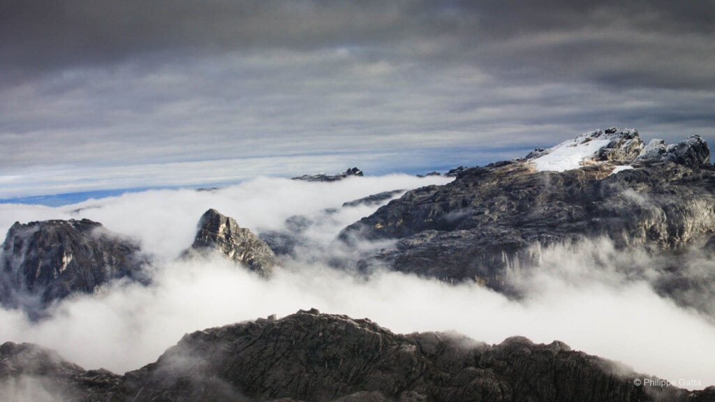
Antarctica is the coldest, driest, and windiest continent on Earth, possessing the highest average elevation of any landmass. Approximately 98% of the continent is covered by an ice sheet with an average thickness of 1.6 km (reaching up to 4.5 km). It holds 90% of the world’s ice and 70% of its fresh water.
Spanning 14 million km², it is 1.3 times the size of Europe. While it has no permanent inhabitants, the population varies between 1,000 and 4,000 seasonal researchers. The interior is a frozen desert where temperatures at Vostok Station have reached a record low of −89.2°C, often accompanied by Katabatic winds exceeding 300 km/h.
Mount Vinson: The Roof of Antarctica
Located in the Ellsworth Mountains, 1,200 km from the South Pole, Mount Vinson is the highest peak in Antarctica. With average temperatures around -30°C, expeditions are only possible from December to February.
Since its first ascent in 1966, only about 1,000 climbers (including only 17 French climbers) have reached the summit. As the continental high point, it is a key component of the 7 Summits Challenge.
Vinson Massif Historic Timeline
First Sight
The mountain was first spotted by a U.S. Navy aircraft during a reconnaissance flight from Byrd Station. It was named after Carl Vinson, a U.S. Congressman who was a major advocate for Antarctic funding and research.
Mapping and Survey
The U.S. Geological Survey (USGS) conducted ground surveys and aerial photography to officially establish the mountain’s location and estimate its elevation within the Sentinel Range.
The First Ascent
On December 18, a team led by Nicholas Clinch successfully reached the summit. The expedition was a joint venture between the American Alpine Club and the National Geographic Society; all ten team members reached the top.
First Commercial Expedition
Private exploration began with Adventure Network International (ANI), the predecessor to ALE. This opened the peak to civilian climbers and those pursuing the Seven Summits challenge.
Precise GPS Measurement
An expedition using high-precision GPS technology established the definitive height of the summit at 4,892m (16,050 ft), correcting earlier estimates that placed it over 5,100 meters.
The Patriot Hills Era
During this period, Patriot Hills served as the vital logistical hub and blue-ice runway for all flights entering the Antarctic interior via the Ilyushin-76, before operations moved to Union Glacier in 2010.
The Expedition
Dec 12-15: France - Punta Arenas
The expedition began with flights from France to Punta Arenas, Chile. This city served as the final staging point before the flight to Antarctica. During our time in Punta Arenas, we conducted final gear checks and organized our food supplies for the duration of the climb.
Dec 16-18
From December 16 to 18, we remained in Punta Arenas due to adverse weather conditions at Patriot Hills. The flight was delayed as the blue-ice runway in Antarctica required specific visibility and wind parameters for a safe landing. We monitored the weather reports daily while waiting for a window to open over the Heritage Range.
Dec 19: Punta Arenas - Patriot Hills
On December 18, we flew from Punta Arenas to Patriot Hills aboard a Russian Ilyushin-76 cargo plane. Patriot Hills had served as the primary base camp for Adventure Network International (ANI) since 1987. Located at an elevation of 1,000 m (3,280 ft) at coordinates 80º19’S / 81º16’W, the camp was situated 3,000 km from the nearest city and only 1,075 km (670 mi) from the South Pole.
This logistical hub served as the starting point for most Antarctic expeditions at the time. We landed on the natural blue-ice runway and arrived at the Patriot Hills camp around 5:00 PM.
Dec 20-22: Stuck at Patriot Hills
From December 20 to 22, we remained at Patriot Hills as a storm moved across the Heritage Range. The weather conditions made any further movement impossible, grounding all air operations during this period.
We stayed at the base camp while waiting for the winds to subside and visibility to improve, which was necessary for the onward Twin Otter flight to the Vinson Massif.
Dec 23: Patriot Hills - Vinson Base Camp (2,100m) - Half Camp (2,500m)
With the return of favorable weather, we flew to Vinson Base Camp. We boarded the third of six scheduled flights, taking off at 5:00 PM. The flight took place under clear skies, with only a few clouds visible over the Vinson Massif itself. We landed at Vinson Base Camp (2,100m) at 6:00 PM and received a briefing from the ALE staff.
Following the arrival, we organized our equipment and food for the higher camps, loading the supplies onto sleds and caching the remaining gear in a designated spot. At 9:00 PM, we departed the base camp in two rope teams of three. We reached Half Camp three hours later, navigating through cloud cover. After pitching the tents and melting snow for water and food, we concluded the day at 2:00 AM.
Distance: 4.5 km. Time: 3h.
Elevation: +400 m.
Dec 24: Vinson Half Camp - Low Camp (2,750m)
We woke up in the clouds with an ambient temperature of -20ºC. Visibility and conditions improved as we ascended the Branscomb Glacier, and temperatures rose as the sun broke through the cloud cover. We maintained a steady pace and reached Low Camp (2,750m) at 7:30 PM.
Upon arrival, we pitched our three tents and constructed snow walls to provide protection against the wind. Taking advantage of the 24-hour daylight of the Antarctic summer, we completed our camp duties and went to sleep late.
Distance: 4.5 km. Time: 4h 30m.
Elevation: +250 m.
Dec 25: Bad Weather at Low Camp (2,750m)
On December 25, Christmas Day, we remained at Low Camp due to unstable weather conditions. After a period of hesitation, we eventually decided to cancel the planned load carry to the High Camp and wait for better visibility.
This decision resulted in the loss of another day of progression, following the significant delays already encountered at Punta Arenas and Patriot Hills earlier in the expedition.
Dec 26: Vinson Low Camp - High Camp (3,710m)
The morning weather remained unchanged, leading us to adjust our strategy and climb directly to High Camp (3,750m) in a single push. This required carrying 25 kg rucksacks to complete the move and avoid an additional load-carry day. We spent several hours dismantling the site and caching gear, food, and one tent before departing Low Camp at 3:00 PM in temperatures of -25ºC.
While the climb began in the clouds, we soon ascended above the ceiling at 3,100 m, gaining views of the Shinn, Gardner, Epperly, and Tyree glaciers. To avoid the crevasses of the headwall, we followed the ridge route for six hours before crossing the upper glacier.
Establishing the High Camp at 11:30 PM proved to be a significant technical challenge. We faced an ambient temperature of -25°C with sustained winds of 60 km/h, creating a windchill factor of approximately -45°C. At these temperatures, the metal tent poles adhered to the fabric on contact. The conditions made it impossible to remove our over-mittens, as any skin exposure posed an immediate risk of frostbite.
We divided into two groups: one team constructed protective ice walls while the other attempted to pitch the tents. To prevent the fabric from tearing in the gale, we secured the tents with cargo nets anchored by snow pickets. This operation lasted until 2:00 AM. Although the Antarctic summer provides 24-hour daylight, the temperature plummeted as the sun dropped low or passed behind the peaks, necessitating immediate shelter. We finally entered our sleeping bags at 2:30 AM.
Distance: 4 km. Time: 8h 30m.
Elevation: +1,000 m.
Dec 27: Rest Day at Vinson High Camp
Dec 28: High Camp - Mt Vinson Summit (4,892m) - High Camp
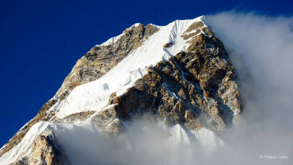
We began our preparations for the summit bid at 7:00 AM by boiling water and organizing our equipment. We departed High Camp at 9:45 AM under clear skies and light wind, with an ambient temperature of -25°C. By noon, as we passed the 4,200 m mark, the wind speed increased and the temperature dropped, necessitating the use of down pants, hand warmers, and heavy over-mittens.
Our original plan was to ascend via a gully rather than the normal route. However, the snow and ice conditions were harder than anticipated. Lacking the specific technical gear required for those conditions, we opted to retreat and join the normal route up Vinson. This detour resulted in a loss of nearly two hours and significant energy as clouds began to build around the summit and neighboring Mount Shinn.
We reached the summit of Mount Vinson (4,892m) at 7:00 PM in poor visibility. This success marked my 6th of the 7 Summits. The descent back to High Camp was completed in 2.5 hours, concluding a long day of high-altitude effort.
Distance: 14 km. Time: 12h 30m.
Elevation: +1,230 m / -1,230 m.
Dec 29: High Camp - Mt Vinson Base Camp
In the morning, we received confirmation that the Twin Otter aircraft were expected to arrive at the base camp at 6:00 PM. We dismantled the tents and cleared the site at noon, departing once again with 25 kg rucksacks. The weather conditions were clear and stable, contrasting with the previous three days.
We arrived at Low Camp at 2:10 PM, where we were informed that severe weather at Patriot Hills had grounded all flight operations. We collected the remaining gear and food supplies from our cache and loaded them onto the sleds. As the last team remaining on the mountain, we proceeded in two rope teams of three.
Conditions remained clear until we reached Half Camp, where we entered a cloud layer. We reached Vinson Base Camp (2,100m) at 6:10 PM. Since the weather at Patriot Hills had not improved, all flights for the day were canceled. We pitched our tents to spend an additional night at the base of the massif, finishing our camp duties by midnight.
Dec 30: Vinson Base Camp - Patriot Hills - Punta Arenas
The weather conditions improved on the morning of December 30, allowing the Twin Otter aircraft to perform the shuttle from Vinson Base Camp back to Patriot Hills. This flight covered approximately 250 km across the Ellsworth Mountains, lasting about 1 hour and 15 minutes.
Upon our return to the Patriot Hills logistical hub, the Russian Ilyushin-76 was cleared for the intercontinental leg. We departed Antarctica for the 4.5-hour flight back to Punta Arenas, Chile. This journey crossed the 60th parallel south and the Drake Passage, covering a total distance of approximately 3,010 km (1,870 mi).
We landed at Presidente Carlos Ibáñez del Campo International Airport, officially concluding the expedition and my successful ascent of the 6th of the 7 Summits.
Information
Mount Vinson Technical Route Profile (Branscomb Glacier)
- Base Camp (2,100m): Located on the lower Branscomb Glacier. Entry point for all expeditions arriving via Twin Otter from Patriot Hills.
- Base Camp to Low Camp (2,750m): A gradual ascent of the Branscomb Glacier. The terrain is relatively flat with a gentle gradient (approx. 10° to 15°). Sleds (pulkas) are typically used for this 9km section to transport heavy gear.
- Low Camp to High Camp (3,750m): The technical crux of the route. It involves ascending a steep snow and ice headwall with slopes reaching 40° to 45°. Climbers transition from sleds to heavy rucksacks here.
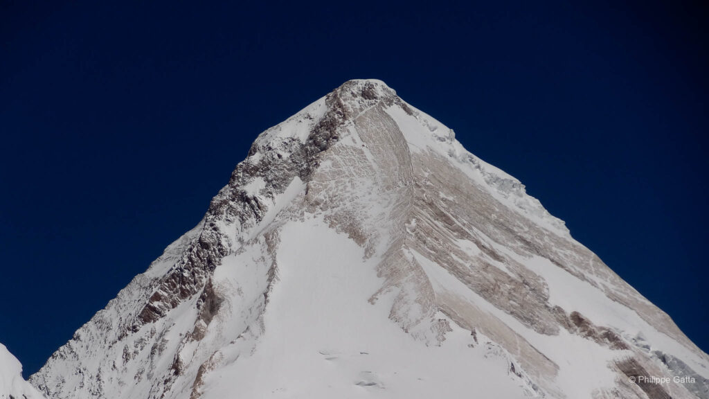
- High Camp to Summit (4,892m): A sustained alpine climb. The route follows the broad Vinson summit valley before ascending a final rocky ridge. The terrain consists of compact snow and ice with inclinations of 25° to 35°. The final summit ridge is narrow and highly exposed to wind.
Antarctic Access and Logistics: ALE
Expedition logistics for the interior of the continent are managed by Antarctic Logistics & Expeditions (ALE). The journey begins in Punta Arenas, Chile, with a 4.5-hour flight that crosses the Drake Passage and the 60th parallel south. This intercontinental leg is operated by a Russian Ilyushin-76 heavy-lift cargo aircraft, specifically designed to land on the natural blue-ice runway at Patriot Hills.
While ALE moved its main operations to Union Glacier in 2010, Patriot Hills (80°S) served as the primary logistical hub and gateway during the 2009 expedition. This base camp, located in the Heritage Range, provided the essential infrastructure for deep-field operations.
The final transfer to the Vinson Base Camp is carried out by DHC-6 Twin Otter aircraft. These versatile planes are equipped with skis, allowing them to land on the softer snow surfaces of the Branscomb Glacier, effectively bridging the gap between the blue-ice runway and the high mountains.
Environmental Protection and "Leave No Trace" Protocols
Antarctica is protected by the Antarctic Treaty and the Madrid Protocol, which mandate the highest environmental standards on Earth. To comply with these regulations, Antarctic Logistics & Expeditions (ALE) enforces a strict “Leave No Trace” policy for all climbers and staff.
The protocols for the 2009 expedition included:
- Waste Management: Every piece of litter, food packaging, and broken equipment had to be collected and flown out of the continent.
- Human Waste: All solid human waste was collected in specialized containers and transported back to Punta Arenas, Chile, for disposal. No biological waste is permitted to remain on the ice.
- Greywater Control: Specific guidelines were followed for the disposal of greywater from cooking to minimize the chemical impact on the glacier.
These measures are essential to preserving the purity of the Antarctic interior, ensuring that the continent remains a pristine wilderness and a protected scientific sanctuary.